Country:
 USA
USARegion:
City:
Latitude and Longitude:
Time Zone:
Postal Code:
IP information under different IP Channel
ip-api
Country
Region
City
ASN
Time Zone
ISP
Blacklist
Proxy
Latitude
Longitude
Postal
Route
IPinfo
Country
Region
City
ASN
Time Zone
ISP
Blacklist
Proxy
Latitude
Longitude
Postal
Route
MaxMind
Country
Region
City
ASN
Time Zone
ISP
Blacklist
Proxy
Latitude
Longitude
Postal
Route
Luminati
Country
USRegion
tx
City
dallas
ASN
Time Zone
America/Chicago
ISP
SINAP-TIX
Latitude
Longitude
Postal
db-ip
Country
Region
City
ASN
Time Zone
ISP
Blacklist
Proxy
Latitude
Longitude
Postal
Route
ipdata
Country
Region
City
ASN
Time Zone
ISP
Blacklist
Proxy
Latitude
Longitude
Postal
Route
Popular places and events near this IP address
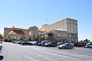
Suncoast Hotel and Casino
Casino hotel in Nevada, United States
Distance: Approx. 3051 meters
Latitude and longitude: 36.169044,-115.291772
Suncoast is a hotel and casino located at 9090 Alta Drive in Las Vegas, Nevada. It is owned and operated by Boyd Gaming. The hotel, located on a 50-acre (20 ha) site, contains 432 rooms and has a 95,898-square-foot (8,909.2 m2) casino, as well as a movie theater, bowling alley and convention space.
JW Marriott Las Vegas
Resort casino in Summerlin, Nevada
Distance: Approx. 3758 meters
Latitude and longitude: 36.1758,-115.2908
JW Marriott Las Vegas Resort and Spa is a resort in Summerlin, Nevada, near Las Vegas. The Rampart Casino is located within the hotel. The property is owned and operated by Hotspur Resorts, which franchises the JW Marriott name from Marriott International.

Faith Lutheran Middle School & High School
Private, coeducational school in Las Vegas, Nevada, United States
Distance: Approx. 3352 meters
Latitude and longitude: 36.15388889,-115.31666667
Faith Lutheran Middle School & High School is a private Christian college-preparatory school located in Summerlin, Nevada. The school, which was founded in 1979, serves grades 6-12 and is affiliated with the Lutheran Church–Missouri Synod. The school is the largest non-public school in Nevada, with over 2,000 students.
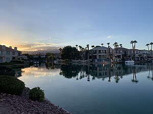
The Lakes, Las Vegas
Distance: Approx. 776 meters
Latitude and longitude: 36.13666667,-115.28611111
The Lakes is a 2-square-mile (5.2 km2) planned community located within the city limits of Las Vegas, Nevada. It is located in the western part of the Las Vegas Valley near the Spring Mountains and Red Rock Canyon National Conservation Area. The centerpiece of the community, and its namesake, is a large man-made lake, Lake Sahara.
Las Vegas Art Museum
Former art museum in Nevada
Distance: Approx. 2201 meters
Latitude and longitude: 36.14526,-115.30629
The Las Vegas Art Museum was an art museum in Las Vegas, Nevada. It was formerly located in a building shared with the Sahara West Library branch of the Las Vegas-Clark County Library District in Las Vegas, NV. The museum closed in 2009. The Las Vegas Art Museum was "dedicated to engaging visitors in the international culture of contemporary art." The museum provided the public with publications, lectures, educational and outreach programs.
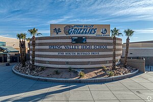
Spring Valley High School (Nevada)
Public high school
Distance: Approx. 3222 meters
Latitude and longitude: 36.12046,-115.25921
Spring Valley High School is located in the Spring Valley community in unincorporated Clark County, Nevada, United States. The school, serving grades 9 through 12, is a part of the Clark County School District. The school's mascot is a grizzly bear.
West Las Vegas
Historic neighborhood in Las Vegas, Nevada, United States
Distance: Approx. 1122 meters
Latitude and longitude: 36.13454,-115.28915
West Las Vegas is a historic neighborhood in Las Vegas, Nevada. This 3.5 sq mi (9.1 km2) area is located northwest of the Las Vegas Strip and the "Spaghetti Bowl" interchange of I-15 and I-11/US 95. It is also known as Historic West Las Vegas and more simply, the Westside.

One Queensridge Place
Residential in Las Vegas, Nevada USA
Distance: Approx. 2847 meters
Latitude and longitude: 36.1663,-115.2945
One Queensridge Place is the name given to two residential skyscrapers located on the west side of the Las Vegas Valley in the Queensridge neighborhood adjacent to the master planned community of Summerlin, Nevada. Construction began in 2005 and concluded in 2007. The buildings are twins, measuring approximately 233.5 feet (71.2 m) high.
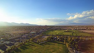
Desert Breeze Park
Park in Spring Valley, Nevada, US
Distance: Approx. 2170 meters
Latitude and longitude: 36.1241,-115.27517
Desert Breeze Park located in Spring Valley, Nevada, is one of the largest parks in the Clark County park system. The regional park is a 240-acre (97 ha) facility that is not fully developed.
Canyon Gate Country Club
Golf club in Nevada, United States
Distance: Approx. 799 meters
Latitude and longitude: 36.14861111,-115.28722222
Canyon Gate Country Club is a golf club to the west of Las Vegas, Nevada. The 6742 yard course was established in 1989, and was designed by Ted Robinson. It hosted the Las Vegas LPGA in 1993.
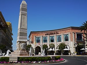
Tivoli Village
Place
Distance: Approx. 2771 meters
Latitude and longitude: 36.167461,-115.286226
Tivoli Village is a mixed-use development center consisting of retail and office space, located on 28.43 acres (11.51 ha) at 410 South Rampart Boulevard in Las Vegas, Nevada, next to the Summerlin community. It is owned by 3D Investments. The project was announced in May 2005, as The Village at Queensridge.

Nevada's 8th Senate district
American legislative district
Distance: Approx. 1806 meters
Latitude and longitude: 36.15,-115.3
Nevada's 8th Senate district is one of 21 districts in the Nevada Senate. It has been represented by Democrat Marilyn Dondero Loop since 2018, succeeding Republican-turned-independent Patricia Farley.
Weather in this IP's area
clear sky
36 Celsius
33 Celsius
35 Celsius
37 Celsius
1014 hPa
11 %
1014 hPa
927 hPa
10000 meters
3.09 m/s
40 degree
06:39:48
18:18:39