Country:
Region:
City:
Latitude and Longitude:
Time Zone:
Postal Code:
IP information under different IP Channel
ip-api
Country
Region
City
ASN
Time Zone
ISP
Blacklist
Proxy
Latitude
Longitude
Postal
Route
Luminati
Country
Region
fl
City
miami
ASN
Time Zone
America/New_York
ISP
QTS-MIA
Latitude
Longitude
Postal
IPinfo
Country
Region
City
ASN
Time Zone
ISP
Blacklist
Proxy
Latitude
Longitude
Postal
Route
db-ip
Country
Region
City
ASN
Time Zone
ISP
Blacklist
Proxy
Latitude
Longitude
Postal
Route
ipdata
Country
Region
City
ASN
Time Zone
ISP
Blacklist
Proxy
Latitude
Longitude
Postal
Route
Popular places and events near this IP address

Coconut Grove station
Miami-Dade Transit metro station in Florida
Distance: Approx. 1674 meters
Latitude and longitude: 25.73972222,-80.23861111
Coconut Grove station is a station on the Metrorail rapid transit system on the western end of the Coconut Grove neighborhood of Miami, Florida. The station is located at the intersection of South Dixie Highway (US 1) and West 27th Avenue/Grapeland Boulevard (SR 9), opening to service on May 20, 1984. In 2018, there were plans to make the station entirely solar-powered.

Vizcaya Museum and Gardens
Historic house in Florida, United States
Distance: Approx. 1587 meters
Latitude and longitude: 25.74361111,-80.21027778
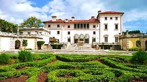
The Vizcaya Museum and Gardens, previously known as Villa Vizcaya, is the former villa and estate of businessman James Deering, of the Deering McCormick-International Harvester fortune, on Biscayne Bay in the present-day Coconut Grove neighborhood of Miami, Florida. The early 20th-century Vizcaya estate also includes extensive Italian Renaissance gardens, native woodland landscape, and a historic village outbuildings compound. The landscape and architecture were influenced by Veneto and Tuscan Italian Renaissance models and designed in the Mediterranean Revival architecture style, with Baroque elements.
Coconut Grove Convention Center
Indoor arena and exhibition hall in Miami
Distance: Approx. 1550 meters
Latitude and longitude: 25.728391,-80.236465
The Coconut Grove Convention Center (formerly the Dinner Key Auditorium, also known as the Coconut Grove Expo Center), was an indoor arena and exhibition hall in Miami, Florida. It originally had been built as a hangar at International Pan American Airport in Dinner Key. The venue closed in 2005 and was used as a production studio for six years.

Trapp Homestead
Historic house in Florida, United States
Distance: Approx. 1014 meters
Latitude and longitude: 25.73389683,-80.232847
The Trapp Homestead (also known as the Caleb Trapp House and the Trapp Estate) is a historic home in the Coconut Grove section of the City of Miami, Florida, United States. It is located at 2521 South Bayshore Drive. On November 10, 1994, it was added to the U.S. National Register of Historic Places.
Immaculata-LaSalle High School
Private, coeducational school in Coconut Grove, Miami, , Florida, United States
Distance: Approx. 1258 meters
Latitude and longitude: 25.74333333,-80.21444444
Immaculata-La Salle High School is a private, Roman Catholic high school in the Coconut Grove neighborhood of Miami, Florida. It is part of the Roman Catholic Archdiocese of Miami and located between Mercy Hospital and Vizcaya on South Bayshore Drive. The school was officially founded as Immaculata Academy, a Roman Catholic college preparatory school for girls, on September 1, 1958.

Mercy Hospital (Miami)
Hospital in Florida, United States
Distance: Approx. 1067 meters
Latitude and longitude: 25.74014167,-80.21388611
Mercy Hospital is a 488-bed acute care hospital located in Coconut Grove, Miami, Florida. It is Miami-Dade County's only Catholic hospital. Mercy Hospital was established in 1950.

Miami City Hall
United States historic place
Distance: Approx. 1362 meters
Latitude and longitude: 25.72773,-80.2338
Miami City Hall is the local government headquarters for the City of Miami, Florida. It has been located in the former Pan American Airlines Terminal Building on Dinner Key, which was designed by Delano & Aldrich and constructed in 1934 for the former International Pan American Airport, since 1954. The city's government headquarters originated in Downtown Miami for 58 years until its relocation to Coconut Grove.

Coast Guard Air Station Dinner Key
United States historic place
Distance: Approx. 1191 meters
Latitude and longitude: 25.73121944,-80.23395278
Coast Guard Air Station Dinner Key is a former United States Coast Guard facility located in Dinner Key, Miami, Florida. It was built next to the International Pan American Airport.

International Pan American Airport
Former airport in Florida
Distance: Approx. 1437 meters
Latitude and longitude: 25.72866667,-80.23534722
International Pan American Airport is a former airport in Dinner Key, Miami, Florida operated by Pan American World Airways from 1932 to 1945. During its existence, it operated alongside Coast Guard Air Station Dinner Key.

Grove Isle
Place in Florida, United States
Distance: Approx. 431 meters
Latitude and longitude: 25.7359339,-80.2186599
Grove Isle is a 20-acre (81,000 m2) island lying off the north-east coast of Miami's Coconut Grove neighborhood. Three waterfront hi-rise residences have been built on the island which were master-planned to include a resort hotel, restaurants, marina, club amenities and services.

Coconut Grove Sailing Club
Sailing club in Miami, Florida, US
Distance: Approx. 1931 meters
Latitude and longitude: 25.72597222,-80.23930556
Coconut Grove Sailing Club is a sailing club located in the Coconut Grove neighborhood of Miami, Florida (United States). CGSC is one of the five members of the Biscayne Bay Yacht Racing Association, together with Biscayne Bay Yacht Club, Coral Reef Yacht Club, Key Biscayne Yacht Club and Miami Yacht Club.

The Mutiny Hotel
Hotel in Coconut Grove, Florida
Distance: Approx. 1921 meters
Latitude and longitude: 25.7273,-80.24
The Mutiny Hotel or The Mutiny Hotel on the Bay in Coconut Grove is a luxury hotel and resort located at Biscayne Bay on the Eastern Seaboard southwest of the Downtown Miami Historic District and Miami Beach Architectural District.
Weather in this IP's area
few clouds
24 Celsius
24 Celsius
22 Celsius
25 Celsius
1013 hPa
79 %
1013 hPa
1013 hPa
10000 meters
3.83 m/s
4.07 m/s
103 degree
20 %
06:38:29
17:32:33