Country:
 USA
USARegion:
City:
Latitude and Longitude:
Time Zone:
Postal Code:
IP information under different IP Channel
ip-api
Country
Region
City
ASN
Time Zone
ISP
Blacklist
Proxy
Latitude
Longitude
Postal
Route
IPinfo
Country
Region
City
ASN
Time Zone
ISP
Blacklist
Proxy
Latitude
Longitude
Postal
Route
MaxMind
Country
Region
City
ASN
Time Zone
ISP
Blacklist
Proxy
Latitude
Longitude
Postal
Route
Luminati
Country
USRegion
nc
City
asheville
ASN
Time Zone
America/New_York
ISP
SKYRUNNER-INC
Latitude
Longitude
Postal
db-ip
Country
Region
City
ASN
Time Zone
ISP
Blacklist
Proxy
Latitude
Longitude
Postal
Route
ipdata
Country
Region
City
ASN
Time Zone
ISP
Blacklist
Proxy
Latitude
Longitude
Postal
Route
Popular places and events near this IP address

Haywood County, North Carolina
County in North Carolina, United States
Distance: Approx. 5535 meters
Latitude and longitude: 35.56,-82.98
Haywood County is a county located in the U.S. state of North Carolina. As of the 2020 census, the population was 62,089. The county seat and its largest community is Waynesville.
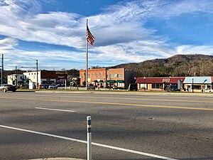
Clyde, North Carolina
Town in North Carolina, United States
Distance: Approx. 3425 meters
Latitude and longitude: 35.53305556,-82.91083333
Clyde is a town in Haywood County, North Carolina, United States. The 2010 census recorded the population at 1,223 people. It is part of the Asheville Metropolitan Statistical Area.

West Canton, North Carolina
Census-designated place in North Carolina, United States
Distance: Approx. 5440 meters
Latitude and longitude: 35.53833333,-82.86722222
West Canton is an unincorporated community and census-designated place (CDP) in Haywood County, North Carolina, United States. The population was 1,247 at the 2010 census. It is part of the Asheville Metropolitan Statistical Area.

Tuscola High School
American public school in North Carolina
Distance: Approx. 5254 meters
Latitude and longitude: 35.523715,-82.9509695
Tuscola High School is a public senior high school located in Waynesville, North Carolina, United States, about 30 miles (48 kilometers) west-southwest of Asheville. Tuscola High School succeeded the original Waynesville Township High School during the 1966 consolidation that merged Fines Creek and Crabtree High Schools with Waynesville. The school was built in the Tuscola community of East Waynesville, near Lake Junaluska and was named after the community in which it was built.
WQNS
Radio station in Woodfin, North Carolina
Distance: Approx. 1270 meters
Latitude and longitude: 35.569,-82.907
WQNS (105.1 FM, "Rock 105.1") is a mainstream rock radio station in Asheville, North Carolina.

Haywood Community College
Public college in Clyde, North Carolina, US.
Distance: Approx. 4091 meters
Latitude and longitude: 35.52755,-82.93043
Haywood Community College is a public community college in Clyde, North Carolina. It is part of the North Carolina Community College System. Established in 1965, the college offers associate degree programs and online courses in programs such as forestry, fish and wildlife management, and professional crafts.
Crabtree, North Carolina
Unincorporated community in North Carolina, US
Distance: Approx. 4737 meters
Latitude and longitude: 35.60166667,-82.94111111
Crabtree is an unincorporated community in Haywood County, North Carolina, United States. It is located north of Lake Junaluska along the Pigeon River. The Davis Family House and Mount Zion United Methodist Church are listed on the National Register of Historic Places.
Haywood Early College High School
American public school in North Carolina
Distance: Approx. 4252 meters
Latitude and longitude: 35.5256,-82.9279
Haywood Early College is a public high school located on the campus of Haywood Community College. Haywood Early College High School enrolls students in grades 9 through 13. Students who complete the full program earn both a high school diploma and a two-year transfer degree.
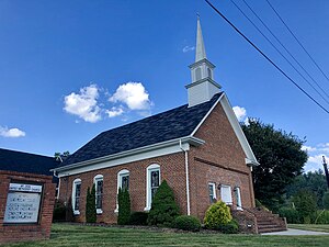
Mount Zion United Methodist Church (Crabtree, North Carolina)
Historic church in North Carolina, United States
Distance: Approx. 4861 meters
Latitude and longitude: 35.605,-82.90388889
The Mount Zion United Methodist Church is a historic Methodist church located near Crabtree, Haywood County, North Carolina. It was built in 1883, and is a three bay by four bay rectangular gable front brick church. The church has been altered significantly during three separate rehabilitation projects undertaken since 1950.
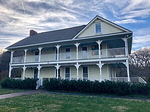
Shook-Welch-Smathers House
Historic house in North Carolina, United States
Distance: Approx. 3499 meters
Latitude and longitude: 35.53166667,-82.91861111
Shook-Welch-Smathers House is a historic home located at Clyde, Haywood County, North Carolina. It was built over three principal periods of construction in the 19th century: c. 1810–1820; c.
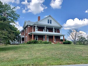
Patton Farm
Historic farm in North Carolina, United States
Distance: Approx. 4728 meters
Latitude and longitude: 35.53888889,-82.87611111
Patton Farm is a historic farm complex located near Phillipsville, Haywood County, North Carolina. The farmhouse was built about 1880, and is a two-story, three bay by one bay, brick dwelling with Italianate style design elements. It has a gable roof and a 2 1/2-story brick rear ell.

Iron Duff, North Carolina
Populated place in North Carolina, United States
Distance: Approx. 4945 meters
Latitude and longitude: 35.579,-82.97
Iron Duff (also Aaron Duff, or Ironduff) is an unincorporated community in Haywood County, North Carolina, United States.
Weather in this IP's area
clear sky
15 Celsius
15 Celsius
13 Celsius
15 Celsius
1015 hPa
95 %
1015 hPa
892 hPa
10000 meters
0.54 m/s
0.75 m/s
176 degree
8 %
07:17:45
19:32:56