199.168.164.17 - IP Lookup: Free IP Address Lookup, Postal Code Lookup, IP Location Lookup, IP ASN, Public IP
Country:
Region:
City:
Location:
Time Zone:
Postal Code:
IP information under different IP Channel
ip-api
Country
Region
City
ASN
Time Zone
ISP
Blacklist
Proxy
Latitude
Longitude
Postal
Route
Luminati
Country
ASN
Time Zone
America/Chicago
ISP
SRS-6-Z-7381
Latitude
Longitude
Postal
IPinfo
Country
Region
City
ASN
Time Zone
ISP
Blacklist
Proxy
Latitude
Longitude
Postal
Route
IP2Location
199.168.164.17Country
Region
georgia
City
atlanta
Time Zone
America/New_York
ISP
Language
User-Agent
Latitude
Longitude
Postal
db-ip
Country
Region
City
ASN
Time Zone
ISP
Blacklist
Proxy
Latitude
Longitude
Postal
Route
ipdata
Country
Region
City
ASN
Time Zone
ISP
Blacklist
Proxy
Latitude
Longitude
Postal
Route
Popular places and events near this IP address

Underground Atlanta
Place in Atlanta, Georgia, U.S.
Distance: Approx. 96 meters
Latitude and longitude: 33.75274,-84.39008
Underground Atlanta is a shopping and entertainment district in the Five Points neighborhood of downtown Atlanta, Georgia, United States, near the Five Points MARTA station. It is currently undergoing renovations. First opened in 1969, it takes advantage of the viaducts built over the city's many railroad tracks to accommodate later automobile traffic.

Five Points, Atlanta
Five-street intersection and district in Downtown Atlanta, Georgia, United States
Distance: Approx. 85 meters
Latitude and longitude: 33.75432,-84.38979
Five Points is a district of Atlanta, Georgia, United States, the primary reference for the downtown area.
Kimball House (Atlanta)
Distance: Approx. 49 meters
Latitude and longitude: 33.7538,-84.38963
The Kimball House was the name of two historical hotels in Atlanta, Georgia. United States. Both were constructed on an entire city block at the south-southeast corner of Five Points, bounded by Whitehall Street (now part of Peachtree Street), Decatur Street, Pryor Street, and Wall Street, a block now occupied by a multi-story parking garage.

Area codes 678, 470, and 943
Telephone area codes for the Atlanta metropolitan area
Distance: Approx. 107 meters
Latitude and longitude: 33.75449,-84.38966
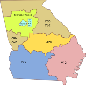
Area codes 678, 470, and 943 are telephone area codes in the North American Numbering Plan (NANP) for the U.S. State of Georgia in the Atlanta metropolitan area. The area codes are assigned in an overlay plan to a combined numbering plan area (NPA) consisting of 404 (Atlanta and its suburbs inside Interstate 285) and 770 (Atlanta suburbs and exurbs outside of I-285).
Andrew Young School of Policy Studies
Department of Georgia State University
Distance: Approx. 78 meters
Latitude and longitude: 33.7543,-84.3901
The Andrew Young School of Policy Studies (AYSPS) is a school of public policy and one of 12 schools and colleges that constitute Georgia State University. Founded in 1996 as the Georgia State University Policy School, the school was named after civil rights leader Andrew Young in 1999. AYSPS houses the Departments of Criminal Justice & Criminology, Economics, and Public Management & Policy, the School of Social Work, and the Urban Studies Institute.
Murrell's Row
Human settlement in Atlanta, Georgia, United States of America
Distance: Approx. 100 meters
Latitude and longitude: 33.7542,-84.3893
Murrell's Row was a red-light district of Atlanta in the mid 19th century "starting at the juncture of Line, Decatur and Peachtree streets" (i.e., at today's Five Points "and running back towards Pryor on Decatur street". According to Archival Atlanta: Named for the notorious Tennessee murderer, John A. Murrell, this section of town was a favorite hangout for thieves, gamblers, cutthroats, and prostitutes. Drunken brawls and cockfights were common and expected here.
Atlanta Hotel
Former hotel in Atlanta, Georgia
Distance: Approx. 48 meters
Latitude and longitude: 33.75388889,-84.38972222
The Atlanta Hotel, also known as Thompson's Hotel, was one of the original hotels in antebellum Atlanta, Georgia, United States. It stood at the northwest side of State Square, pre-war Atlanta's central square, on the northwest side of Pryor Street between Decatur Street (then Marietta Street) and what is now Wall Street (which before the war was the railroad track). The hotel was run by Joseph Thompson.

Trout House
Hotel in antebellum Atlanta, Georgia
Distance: Approx. 60 meters
Latitude and longitude: 33.7538,-84.3895
The Trout House was one of three hotels in antebellum Atlanta, Georgia, along with the Atlanta Hotel and Washington Hall. It was built in 1849 by Jeremiah F. Trout. It was a four-story brick building at the southwest corner of Decatur and Pryor Streets, facing the union depot and State Square.

Peachtree Arcade
Shopping arcade in Georgia, United States
Distance: Approx. 76 meters
Latitude and longitude: 33.75416667,-84.39055556
The Peachtree Arcade was a shopping arcade in downtown Atlanta, Georgia, United States. The building, modeled after the Arcade in Cleveland, was designed by Atlanta-based architect A. Ten Eyck Brown and was located between Peachtree Street and Broad Street near Five Points. Construction began in 1917 and was completed the following year.
Norcross Building
Distance: Approx. 78 meters
Latitude and longitude: 33.7543,-84.3901
The Norcross Building (4 Marietta Street NW, Atlanta) occupied the southwest corner of Peachtree Street and Marietta Street at Five Points in downtown Atlanta. Today the Andrew Young School of Policy Studies is located on the site. The building was owned by Jonathan Norcross, "father of Atlanta." An 1859 directory already lists a Norcross Building in this location at that time.
Republic Block
Distance: Approx. 102 meters
Latitude and longitude: 33.7536,-84.389
The Republic Block (completed in 1873) was at the time of its completion one of the most remarkable commercial constructions in Atlanta. It faced Pryor Street between Decatur St. and Railroad Ave.

Five Points Monument
Distance: Approx. 99 meters
Latitude and longitude: 33.75446,-84.38983
The Five Points Monument is a large public monument in Atlanta, Georgia, United States. Located in the Five Points district, the monument was designed by George Beasley and installed in 1996.
Weather in this IP's area
clear sky
-5 Celsius
-12 Celsius
-5 Celsius
-4 Celsius
1026 hPa
76 %
1026 hPa
990 hPa
10000 meters
6.69 m/s
330 degree
