Country:
 USA
USARegion:
City:
Latitude and Longitude:
Time Zone:
Postal Code:
IP information under different IP Channel
ip-api
Country
Region
City
ASN
Time Zone
ISP
Blacklist
Proxy
Latitude
Longitude
Postal
Route
IPinfo
Country
Region
City
ASN
Time Zone
ISP
Blacklist
Proxy
Latitude
Longitude
Postal
Route
MaxMind
Country
Region
City
ASN
Time Zone
ISP
Blacklist
Proxy
Latitude
Longitude
Postal
Route
Luminati
Country
USASN
Time Zone
America/Chicago
ISP
123NET
Latitude
Longitude
Postal
db-ip
Country
Region
City
ASN
Time Zone
ISP
Blacklist
Proxy
Latitude
Longitude
Postal
Route
ipdata
Country
Region
City
ASN
Time Zone
ISP
Blacklist
Proxy
Latitude
Longitude
Postal
Route
Popular places and events near this IP address

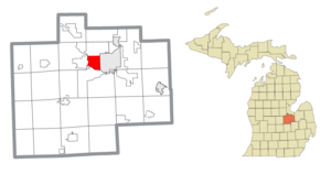
Saginaw Charter Township, Michigan
Charter township in Michigan, United States
Distance: Approx. 3448 meters
Latitude and longitude: 43.44472222,-84.00972222
Saginaw Charter Township is a charter township of Saginaw County in the U.S. state of Michigan. The population was 41,679 at the 2020 census. The city of Saginaw is adjacent to the township to the southeast, but is administratively autonomous.
Saginaw Township South, Michigan
Place in Michigan, United States
Distance: Approx. 546 meters
Latitude and longitude: 43.41722222,-84.01916667
Saginaw Township South is an unincorporated community and former census-designated place (CDP) in Saginaw County in the U.S. state of Michigan. The community is located within Saginaw Charter Township, and the CDP boundaries consisted of the southern portion of the township. Saginaw Township North is in the northern portion of the township.

Shields, Michigan
Census-designated place & unincorporated community in Michigan, United States
Distance: Approx. 4004 meters
Latitude and longitude: 43.42111111,-84.07472222
Shields is an unincorporated community in Thomas Township, Saginaw County in the U.S. state of Michigan. It is also a census-designated place (CDP) for statistical purposes, but with no legal status as an incorporated municipality. The population of the CDP was 7,035 at the 2020 census.
Arthur Hill High School
Public high school in Saginaw, Michigan
Distance: Approx. 3270 meters
Latitude and longitude: 43.4302,-83.9903
Arthur Hill High School was a public high school in Saginaw, Michigan, United States. It served students in grades 9–12 as one of three high schools in the Saginaw Public School District.
Nouvel Catholic Central High School
Private high school in Saginaw Charter Township, Michigan, United States
Distance: Approx. 3353 meters
Latitude and longitude: 43.44583333,-84.03138889
Nouvel Catholic Central High School is a private, Catholic high school located in Saginaw Charter Township, Michigan and serving the Saginaw region. Nouvel is a high school that enrolls approximately 150 students. The school was formed in 1984 as a consolidation of the three then-remaining Saginaw area Catholic high schools, Saints Peter and Paul, Saint Stephen's, and Saint Mary's Cathedral High Schools.

Michigan Lutheran Seminary
Private college preparatory school in Saginaw, Michigan, United States
Distance: Approx. 4100 meters
Latitude and longitude: 43.42861111,-83.97805556
Michigan Lutheran Seminary (MLS) is a coeducational, private preparatory school for boarding and day students in grades 9 through 12. Located in Saginaw, Michigan, the school encourages students to become pastors and teachers in the Wisconsin Evangelical Lutheran Synod, continuing their education at Martin Luther College in New Ulm, Minnesota. Founded as a preparatory school in 1910, MLS is operated by the Wisconsin Synod.
Saginaw Intermediate School District
School district in Michigan, USA
Distance: Approx. 1098 meters
Latitude and longitude: 43.41495,-84.0392
The Saginaw Intermediate School District (SISD) is an intermediate school district in Michigan, headquartered in Saginaw. Most of Saginaw County is served by the Saginaw Intermediate School District, which coordinates the efforts of local boards of education, but has no operating authority over schools. Local school boards in Michigan retain great autonomy over day-to-day operations.

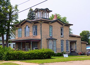
Abel Brockway House
United States historic place
Distance: Approx. 3430 meters
Latitude and longitude: 43.4175,-83.98333333
The Abel Brockway House is a single family home located at 1631 Brockway Street in Saginaw, Michigan. It was listed on the National Register of Historic Places in 1982.
Wenzel House
United States historic place
Distance: Approx. 4180 meters
Latitude and longitude: 43.41111111,-83.97444444
The Wenzel House is a single family home located at 1203 South Fayette in Saginaw, Michigan. It was listed on the National Register of Historic Places in 1982.

Ammi and William Wright House
United States historic place
Distance: Approx. 3257 meters
Latitude and longitude: 43.41361111,-83.98555556
The Ammi and William Wright House is a single family home located at 207 Garden Lane in Saginaw, Michigan. It was listed on the National Register of Historic Places in 1982.
Center Road – Tittabawassee River Bridge
United States historic place
Distance: Approx. 2638 meters
Latitude and longitude: 43.39361111,-84.015
The Center Road – Tittabawassee River Bridge was a bridge carrying Center Road over the Tittabawassee River in James Township, Michigan. It was listed on the National Register of Historic Places in 1999.
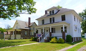
Roethke Houses
United States historic place
Distance: Approx. 3112 meters
Latitude and longitude: 43.41666667,-83.98722222
The Roethke Houses are two side-by-side single family homes located at 1759 and 1805 Gratiot Avenue in Saginaw, Michigan. They were listed on the National Register of Historic Places in 2001.
Weather in this IP's area
clear sky
7 Celsius
5 Celsius
7 Celsius
9 Celsius
1032 hPa
76 %
1032 hPa
1010 hPa
10000 meters
3.09 m/s
190 degree
07:55:22
18:46:14