Country:
Region:
City:
Latitude and Longitude:
Time Zone:
Postal Code:
IP information under different IP Channel
ip-api
Country
Region
City
ASN
Time Zone
ISP
Blacklist
Proxy
Latitude
Longitude
Postal
Route
Luminati
Country
ASN
Time Zone
America/Chicago
ISP
BTCS-BSPS-ASN-1
Latitude
Longitude
Postal
IPinfo
Country
Region
City
ASN
Time Zone
ISP
Blacklist
Proxy
Latitude
Longitude
Postal
Route
db-ip
Country
Region
City
ASN
Time Zone
ISP
Blacklist
Proxy
Latitude
Longitude
Postal
Route
ipdata
Country
Region
City
ASN
Time Zone
ISP
Blacklist
Proxy
Latitude
Longitude
Postal
Route
Popular places and events near this IP address
Home Insurance Building
Early skyscraper in Chicago
Distance: Approx. 70 meters
Latitude and longitude: 41.8796,-87.632
The Home Insurance Building was a skyscraper that stood in Chicago from 1885 to its demolition in 1931. Originally ten stories and 138 ft (42.1 m) tall, it was designed by William Le Baron Jenney in 1884 and completed the next year. Two floors were added in 1891, bringing its now finished height to 180 feet (54.9 meters).

Area code 312
Area code of Downtown Chicago
Distance: Approx. 97 meters
Latitude and longitude: 41.88,-87.6316667
Area code 312 is a telephone area code in the North American Numbering Plan for the city of Chicago, including downtown, the Chicago Loop, and its immediate environs. The numbering plan area is completely surrounded by area code 773, which serves the rest of Chicago. Both area codes form an overlay complex with area code 872.

Rookery Building
Building in Chicago
Distance: Approx. 98 meters
Latitude and longitude: 41.87908333,-87.63211111
The Rookery Building is a historic office building located at 209 South LaSalle Street in the Chicago Loop. Completed by architects Daniel Burnham and John Wellborn Root of Burnham and Root in 1888, it is considered one of their masterpiece buildings, and was once the location of their offices. The building is 181 feet (55 m) in height, twelve stories tall, and is considered the oldest standing high-rise in Chicago.

Field Building (Chicago)
Building in Chicago, Illinois
Distance: Approx. 99 meters
Latitude and longitude: 41.8798,-87.6316
The Field Building, also known as the LaSalle National Bank Building and Bank of America Building is an art deco office building at 135 South LaSalle Street in the Loop community area of Chicago, Illinois in the United States. The building was designated a Chicago Landmark February 9, 1934.

Harris Bank Addition II
Office in Chicago, Illinois
Distance: Approx. 100 meters
Latitude and longitude: 41.8804,-87.6319
Harris Bank Addition II is a 510 ft (160 m) tall skyscraper in Chicago, Illinois, United States. It was completed in 1974 and has 38 floors. Skidmore, Owings and Merrill designed the building in the International style which is the 83rd tallest in Chicago and has 592,000 sq ft (55,000 m2) of floor space.

U.S. Bank Building (Chicago)
Skyscraper in Chicago, Illinois
Distance: Approx. 8 meters
Latitude and longitude: 41.8798,-87.6327
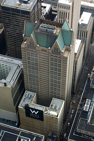
U.S. Bank Building, formerly 190 South LaSalle Street, is a 573 feet (175 m) tall skyscraper in Chicago, Illinois.

Area code 872
Telephone overlay area code in Chicago, Illinois
Distance: Approx. 97 meters
Latitude and longitude: 41.88,-87.6316667
Area code 872 is a telephone area code in the North American Numbering Plan for Chicago in the U.S. state of Illinois. It is an overlay code for a numbering plan area that comprises those of area codes 312 and 773. The overlay commenced service on November 7, 2009.

Area code 773
Area code of Chicago outside of Downtown
Distance: Approx. 97 meters
Latitude and longitude: 41.88,-87.6316667
Area code 773 serves Chicago, Illinois, outside the Loop and the innermost neighborhoods. Originally, all of Chicago and its suburbs used area code 312. In 1989, area code 708 was created for the suburbs, leaving the city in area code 312.

Rand McNally Building
Demolished skyscraper in Chicago, Illinois
Distance: Approx. 69 meters
Latitude and longitude: 41.8792,-87.633
The Rand McNally Building was an early skyscraper at 160–174 Adams Street in Chicago, Illinois, built in 1889 and demolished in 1911. Designed by Burnham and Root, it was the world's first all-steel framed skyscraper.
Continental and Commercial National Bank
United States historic place
Distance: Approx. 85 meters
Latitude and longitude: 41.87916667,-87.63222222
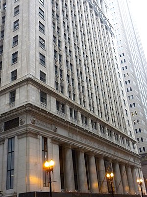
The Continental and Commercial National Bank is a historic office building located at 208 S. LaSalle Street in Chicago's Loop. The 21-story building was built in 1911-14 for the Continental and Commercial National Bank, at the time one of the largest banks in the nation. Architect Daniel Burnham designed the building in the Classical Revival style; Burnham, who was perhaps best known for his 1909 plan of Chicago, was a proponent of the style and used it in office buildings in multiple cities.

West Loop–LaSalle Street Historic District
Historic district in Illinois, United States
Distance: Approx. 97 meters
Latitude and longitude: 41.88055556,-87.63222222
The West Loop–LaSalle Street Historic District is a historic district centered on LaSalle Street in the western Chicago Loop. The district was added to the National Register of Historic Places on June 1, 2013. A boundary increase on July 24, 2017, added two buildings at 330 S. Wells Street and 212 W. Van Buren Street to the district.

Temperance Temple (Chicago)
Commercial in Illinois, U.S.
Distance: Approx. 56 meters
Latitude and longitude: 41.8803,-87.6328
Temperance Temple (also known as Women's Temple or Woman's Temple) served as the headquarters of the National Woman's Christian Temperance Union (WCTU). It was located in Chicago, Illinois at the southwest corner of LaSalle Street and Monroe Street, in the center of city's financial district. Work was begun in July, 1890, and the building was ready for occupancy in May 1892.
Weather in this IP's area
moderate rain
18 Celsius
18 Celsius
17 Celsius
18 Celsius
1009 hPa
94 %
1009 hPa
988 hPa
8047 meters
9.83 m/s
13.86 m/s
157 degree
100 %
06:27:12
16:40:57

