199.16.125.45 - IP Lookup: Free IP Address Lookup, Postal Code Lookup, IP Location Lookup, IP ASN, Public IP
Country:
 USA
USARegion:
City:
Location:
Time Zone:
Postal Code:
ISP:
ASN:
language:
User-Agent:
Proxy IP:
Blacklist:
IP information under different IP Channel
ip-api
Country
Region
City
ASN
Time Zone
ISP
Blacklist
Proxy
Latitude
Longitude
Postal
Route
db-ip
Country
Region
City
ASN
Time Zone
ISP
Blacklist
Proxy
Latitude
Longitude
Postal
Route
IPinfo
Country
Region
City
ASN
Time Zone
ISP
Blacklist
Proxy
Latitude
Longitude
Postal
Route
IP2Location
199.16.125.45Country
usRegion
arizona
City
tucson
Time Zone
America/Phoenix
ISP
Language
User-Agent
Latitude
Longitude
Postal
ipdata
Country
Region
City
ASN
Time Zone
ISP
Blacklist
Proxy
Latitude
Longitude
Postal
Route
Popular places and events near this IP address

Davis–Monthan Air Force Base
US Air Force base in Arizona, United States
Distance: Approx. 4690 meters
Latitude and longitude: 32.16361111,-110.84944444
Davis–Monthan Air Force Base (DM AFB) (IATA: DMA, ICAO: KDMA, FAA LID: DMA) is a United States Air Force base 5 miles (4 nmi; 8 km) southeast of downtown Tucson, Arizona. It was established in 1925 as Davis–Monthan Landing Field. The host unit for Davis–Monthan AFB is the 355th Wing (355 WG) assigned to Twelfth Air Force (12AF), part of Air Combat Command (ACC).
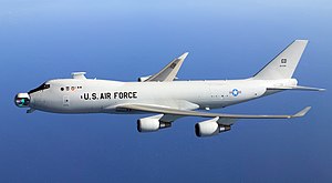
Boeing YAL-1
Airborne laser demonstrator aircraft by Boeing
Distance: Approx. 4560 meters
Latitude and longitude: 32.15483333,-110.84194444
The Boeing YAL-1 airborne laser testbed was a modified Boeing 747-400F with a megawatt-class chemical oxygen iodine laser (COIL) mounted inside. It was primarily designed to test its feasibility as a missile defense system to destroy tactical ballistic missiles (TBMs) while in boost phase. The aircraft was designated YAL-1A in 2004 by the U.S. Department of Defense.

Convair XC-99
American prototype cargo plane (1949–57)
Distance: Approx. 5029 meters
Latitude and longitude: 32.1487,-110.84233
The Convair XC-99, AF Ser. No. 43-52436, is a prototype heavy cargo aircraft built by Convair for the United States Air Force.

309th Aerospace Maintenance and Regeneration Group
US Air Force unit
Distance: Approx. 4903 meters
Latitude and longitude: 32.16,-110.85
The 309th Aerospace Maintenance and Regeneration Group (309th AMARG), often called The Boneyard, is a United States Air Force aircraft and missile storage and maintenance facility in Tucson, Arizona, located on Davis–Monthan Air Force Base. The 309th AMARG was previously Aerospace Maintenance and Regeneration Center, and the Military Aircraft Storage and Disposition Center. The 309th AMARG takes care of nearly 4,000 aircraft, which makes it the largest aircraft storage and preservation facility in the world.

Palo Verde High Magnet School (Arizona)
Public school in Tucson, Arizona, United States
Distance: Approx. 4792 meters
Latitude and longitude: 32.205099,-110.844382
Palo Verde High Magnet School is located at 1302 South Avenida Vega in Terra Del Sol, Tucson, Arizona. The school has been open since 1962. Its current principal is Eric Brock.
St. Augustine Catholic High School (Tucson, Arizona)
Private, coeducational school
Distance: Approx. 2674 meters
Latitude and longitude: 32.20361111,-110.80416667
St. Augustine Catholic High School is a private, coeducational, Roman Catholic high school on the east side of Tucson, Arizona, United States, located in and administered by the Diocese of Tucson. The school opened in August 2003.
Sahuaro High School
Public secondary school in Tucson, Arizona, United States
Distance: Approx. 5099 meters
Latitude and longitude: 32.22527778,-110.8075
Sahuaro High School is a public high school located in Tucson, Arizona, United States, part of the Tucson Unified School District. It is located on the far east side of the city at 545 North Camino Seco, just north of Vicksburg Street between Broadway and Speedway Boulevards. Contemporary establishments Sabino High School and Santa Rita High School have similar facilities.
Lakeside Lake
Lake in Pima County, Arizona
Distance: Approx. 1422 meters
Latitude and longitude: 32.18611111,-110.81638889
Lakeside Lake is located at Chuck Ford-Lakeside Park in east Tucson, Arizona, United States, on the northwest corner of Stella Road and Sarnoff Drive.
Santa Rita High School
Public school in Tucson, Arizona, United States
Distance: Approx. 1845 meters
Latitude and longitude: 32.176128,-110.822543
Santa Rita High School is located in Groves Lincoln Park, Tucson, Arizona. The school was established in 1969. It was named after the Santa Rita Mountains, one of the mountain ranges surrounding the Tucson valley.

Compass High School (Tucson, Arizona)
Public charter high school
Distance: Approx. 3135 meters
Latitude and longitude: 32.2056,-110.8162
Compass High School is a public charter high school in Tucson, Arizona, founded in 2001. The school was founded by Debbie and John Ferguson and is currently operated by her children, with her son, Kerk Ferguson as the active Director and Manager of the school's operations.
Academy of Tucson
Public charter school in Tucson, Arizona, United States
Distance: Approx. 4757 meters
Latitude and longitude: 32.2059,-110.7636
Academy of Tucson is a public charter school in Tucson, Arizona. In 1986, it was founded as a private high school. It became a charter school in 1999 and added the elementary and middle schools in 2003.
Canyon Rose Academy
High school in Tucson, Arizona, US
Distance: Approx. 5330 meters
Latitude and longitude: 32.1933807,-110.857585
Canyon Rose Academy is a tuition free public high school in Tucson, Arizona, United States. Canyon Rose serves the communities of central and eastern Tucson.
Weather in this IP's area
broken clouds
14 Celsius
12 Celsius
13 Celsius
15 Celsius
1016 hPa
31 %
1016 hPa
909 hPa
10000 meters
2.57 m/s
120 degree
75 %