199.16.124.222 - IP Lookup: Free IP Address Lookup, Postal Code Lookup, IP Location Lookup, IP ASN, Public IP
Country:
 USA
USARegion:
City:
Location:
Time Zone:
Postal Code:
ISP:
ASN:
language:
User-Agent:
Proxy IP:
Blacklist:
IP information under different IP Channel
ip-api
Country
Region
City
ASN
Time Zone
ISP
Blacklist
Proxy
Latitude
Longitude
Postal
Route
db-ip
Country
Region
City
ASN
Time Zone
ISP
Blacklist
Proxy
Latitude
Longitude
Postal
Route
IPinfo
Country
Region
City
ASN
Time Zone
ISP
Blacklist
Proxy
Latitude
Longitude
Postal
Route
IP2Location
199.16.124.222Country
usRegion
california
City
san lorenzo
Time Zone
America/Los_Angeles
ISP
Language
User-Agent
Latitude
Longitude
Postal
ipdata
Country
Region
City
ASN
Time Zone
ISP
Blacklist
Proxy
Latitude
Longitude
Postal
Route
Popular places and events near this IP address

Ashland, California
Unincorporated community in California, United States
Distance: Approx. 2398 meters
Latitude and longitude: 37.69472222,-122.11388889
Ashland is a census-designated place (CDP) and unincorporated community in Alameda County, California, United States. The population was 23,823 at the 2020 census. Ashland is located between the city of San Leandro to the north, the unincorporated community of Cherryland to the south, the unincorporated community of Castro Valley to the east, and the unincorporated community of San Lorenzo to the southwest.

Cherryland, California
Unincorporated Community in California, United States
Distance: Approx. 2460 meters
Latitude and longitude: 37.67944444,-122.10333333
Cherryland is an unincorporated community and census-designated place (CDP) in Alameda County, California, United States. Cherryland is located between Ashland to the north and the city of Hayward to the south. The population was 15,808 at the 2020 census.
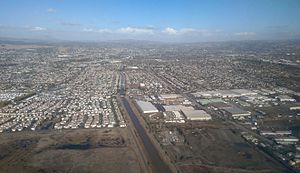
San Lorenzo, California
Unincorporated community in California, United States
Distance: Approx. 683 meters
Latitude and longitude: 37.68111111,-122.12444444
San Lorenzo (Spanish for "Saint Laurence") is a census-designated place (CDP) located in the East Bay of the San Francisco Bay Area in Alameda County, California, United States. The population was 29,581 at the 2020 census. It is an unincorporated community, located at the banks of San Lorenzo Creek.
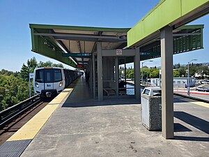
Bay Fair station
Metro station in San Leandro, California, US
Distance: Approx. 2144 meters
Latitude and longitude: 37.697,-122.1265
Bay Fair station is a Bay Area Rapid Transit (BART) station located adjacent to the Bayfair Center mall in San Leandro, California. The station is served by the Orange, Green, and Blue lines. Bay Fair station has a single elevated island platform serving the line's two tracks.

Hayward Executive Airport
Airport in Hayward, California, United States
Distance: Approx. 2298 meters
Latitude and longitude: 37.65888889,-122.12166667
Hayward Executive Airport (IATA: HWD, ICAO: KHWD, FAA LID: HWD) is a municipal airport in Hayward, California. The National Plan of Integrated Airport Systems for 2023–2027 categorized it as a reliever airport. The towered airport near the east shore of San Francisco Bay was formerly the Hayward Air Terminal.

San Lorenzo High School
Public high school in San Lorenzo, California, United States
Distance: Approx. 1291 meters
Latitude and longitude: 37.68705,-122.12188056
San Lorenzo High School, also known as "SLz", is a public high school located in San Lorenzo, California, and is part of the San Lorenzo Unified School District. The school's student body reflects the diversity of its surrounding and nearby communities, namely San Lorenzo, San Leandro, Hayward, and Oakland. As of the 2018-2019 school year, the student demographics are, Hispanic-Latino (62%), followed by Asian (15%), Black (14%), non-Hispanic White (5%), Pacific Islander (2%), American Indian or Alaska Native (less than 1%), and two or more races (2%).
Arroyo High School (San Lorenzo, California)
Public high school in San Lorenzo, California, United States
Distance: Approx. 755 meters
Latitude and longitude: 37.680415,-122.139253
Arroyo High School is located in San Lorenzo, California, and is part of the San Lorenzo Unified School District (SlzUSD). Serving as one of three public high schools for San Lorenzo and parts of San Leandro, its sister high school and cross-town rival is San Lorenzo High School. SlzUSD also has a third high school whose campus is currently under construction.

Meek Mansion
Historic house in California, United States
Distance: Approx. 1818 meters
Latitude and longitude: 37.685,-122.1125
The Meek Mansion is a historic mansion in unincorporated Cherryland, California, just north of Hayward. It is listed on the National Register of Historic Places. Located on nearly 10 acres, the Victorian house was built in 1869 by William Meek.

Kennedy Park (Hayward, California)
Park in Hayward, California, U.S.
Distance: Approx. 1381 meters
Latitude and longitude: 37.66861111,-122.12111111
Kennedy Park is a large, multi-use park in Hayward, California, managed by the Hayward Area Recreation and Park District (HARD). It is the most heavily used park in the district. The park is adjacent to McConaghy Park, which contains McConaghy House, a historic property, built in 1886, and managed as a house museum by HARD and the Hayward Area Historical Society.
East Bay Arts High School
Public school in Hayward, California, United States
Distance: Approx. 1732 meters
Latitude and longitude: 37.6694,-122.1149
East Bay Arts High School is a public high school located in Hayward, California and is part of the San Lorenzo Unified School District. The school has recently gone through many processes of possible closure due to low student population, and other. The school is still currently open and accepting new freshman thanks to multiple protests.
KIPP King Collegiate High School
High school in California, United States
Distance: Approx. 1738 meters
Latitude and longitude: 37.6745,-122.1504
KIPP King Collegiate High School is a free, public charter school located in San Lorenzo, California. Founded in 2007, KIPP King was named after Martin Luther King Jr.
Hayward Acres, California
Unincorporated community in California, United States
Distance: Approx. 1967 meters
Latitude and longitude: 37.66916667,-122.11194444
Hayward Acres is an unincorporated community in Alameda County, California, United States. It is located about 1 mile (1.61 km) southeast of San Lorenzo. In the year 2019, it has a total population of 4,266.
Weather in this IP's area
clear sky
5 Celsius
3 Celsius
3 Celsius
6 Celsius
1021 hPa
66 %
1021 hPa
1011 hPa
10000 meters
1.54 m/s
40 degree