199.15.153.198 - IP Lookup: Free IP Address Lookup, Postal Code Lookup, IP Location Lookup, IP ASN, Public IP
Country:
 USA
USARegion:
City:
Location:
Time Zone:
Postal Code:
ISP:
ASN:
language:
User-Agent:
Proxy IP:
Blacklist:
IP information under different IP Channel
ip-api
Country
Region
City
ASN
Time Zone
ISP
Blacklist
Proxy
Latitude
Longitude
Postal
Route
db-ip
Country
Region
City
ASN
Time Zone
ISP
Blacklist
Proxy
Latitude
Longitude
Postal
Route
IPinfo
Country
Region
City
ASN
Time Zone
ISP
Blacklist
Proxy
Latitude
Longitude
Postal
Route
IP2Location
199.15.153.198Country
usRegion
tennessee
City
dayton
Time Zone
America/New_York
ISP
Language
User-Agent
Latitude
Longitude
Postal
ipdata
Country
Region
City
ASN
Time Zone
ISP
Blacklist
Proxy
Latitude
Longitude
Postal
Route
Popular places and events near this IP address

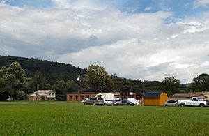
Dayton, Tennessee
City in Tennessee, United States
Distance: Approx. 824 meters
Latitude and longitude: 35.5,-85.01666667
Dayton is a city in and the county seat of Rhea County, Tennessee, United States. As of the 2020 census, the city population was 7,065. The Dayton Urban Cluster includes developed areas adjacent to the city and extends south to Graysville.
Graysville, Tennessee
Town in Tennessee, United States
Distance: Approx. 7798 meters
Latitude and longitude: 35.44777778,-85.0825
Graysville is a town in Rhea County, Tennessee, United States. The population was 1,471 at the 2020 census and 1,502 at the 2010 census.

Bryan College
Christian college in Dayton, Tennessee, US
Distance: Approx. 1664 meters
Latitude and longitude: 35.4976,-84.9991
Bryan College is a private Christian college in Dayton, Tennessee. It was founded in the aftermath of the 1925 Scopes trial to establish an institution of higher education that would teach from a Christian worldview.

Omega Graduate School
Distance: Approx. 4351 meters
Latitude and longitude: 35.4679,-85.0536
Omega Graduate School (formerly Oxford Graduate School) is a private graduate school in Dayton, Tennessee. Omega Graduate School is accredited by the Transnational Association of Christian Colleges and Schools (TRACS). Faculty are primarily Christian in their orientation, although OGS describes itself as "non-sectarian, non-profit, and non-discriminatory".
Mark Anton Airport
Airport
Distance: Approx. 7764 meters
Latitude and longitude: 35.48611111,-84.93111111
Mark Anton Airport (FAA LID: 2A0), also known as Mark Anton Municipal Airport, is a public airport located four miles (6 km) east of the central business district of Dayton, a city in Rhea County, Tennessee, United States. It is owned by the City of Dayton.
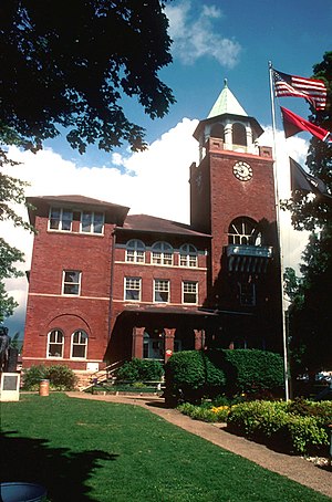
Rhea County Courthouse
United States historic place
Distance: Approx. 426 meters
Latitude and longitude: 35.49492778,-85.012675
The Rhea County Courthouse is a historic county courthouse in the center of Dayton, the county seat of Rhea County, Tennessee. Built in 1891, it is famous as the scene of the Scopes trial of July 1925, in which teacher John T. Scopes faced charges for including Charles Darwin's theory of evolution in his public school lesson. The trial became a clash of titans between lawyers William Jennings Bryan for the prosecution and Clarence Darrow for the defense, and epitomizes the tension between fundamentalism and modernism in a wide range of aspects of American society.

Gooch Creek Arch
Distance: Approx. 6210 meters
Latitude and longitude: 35.54796,-85.00798
Gooch Creek Arch is a natural sandstone arch in Rhea County, Tennessee. It is 45 feet (14 m) high with a span of 78 feet (24 m), making it one of the largest arches in Tennessee. While the arch was first described by Wilbur Nelson in 1915, it could not be located by Corgan and Parks in 1979.

Laurel-Snow State Natural Area
State Natural Area in Rhea County, Tennessee
Distance: Approx. 3833 meters
Latitude and longitude: 35.5267,-85.0223
Laurel-Snow State Natural Area is a Tennessee Class II Natural-Scientific State Natural Area located in Rhea County, Tennessee, near Dayton, on Walden Ridge of the Cumberland Plateau. The 2,259-acre (9.14 km2) area is owned by the State of Tennessee and managed by the Tennessee Department of Environment and Conservation. It is a component of the Cumberland Trail, a linear park.
Five Points, Rhea County, Tennessee
Unincorporated community in Tennessee, United States
Distance: Approx. 5331 meters
Latitude and longitude: 35.44472222,-85.0175
Five Points is an unincorporated community in Rhea County, Tennessee, United States. Five Points is located along Tennessee State Route 60 3.4 miles (5.5 km) south of Dayton.

Broyles-Darwin House
Historic house in Tennessee, United States
Distance: Approx. 890 meters
Latitude and longitude: 35.485,-85.01944444
The Broyles-Darwin House is a historic mansion in Dayton, Tennessee, United States. It was built circa 1860 for Stephen Sanders Decatur Broyles. Broyles served in the Confederate States Army during the American Civil War of 1861–1865.
Dayton City School
School district and elementary/middle school in Dayton, Tennessee
Distance: Approx. 579 meters
Latitude and longitude: 35.4874,-85.0166
Dayton City School (DCS) is a municipal school district in Dayton, Tennessee which consists of a single K-8 school. The district's attendance boundary is the city limits of Dayton. High school students attend Rhea County High School, operated by Rhea County Schools.

Dr. Walter Thomison House
United States historic place
Distance: Approx. 783 meters
Latitude and longitude: 35.48611111,-85.01972222
The Dr. Walter Thomison House is a historic house in Dayton, Tennessee, U.S.. it was built in 1890 for Walter Thomison, a physician, and his wife, Ella Darwin Thomison.
Weather in this IP's area
overcast clouds
17 Celsius
17 Celsius
17 Celsius
17 Celsius
1022 hPa
88 %
1022 hPa
980 hPa
10000 meters
0.84 m/s
0.82 m/s
273 degree
96 %