Country:
Region:
City:
Latitude and Longitude:
Time Zone:
Postal Code:
IP information under different IP Channel
ip-api
Country
Region
City
ASN
Time Zone
ISP
Blacklist
Proxy
Latitude
Longitude
Postal
Route
Luminati
Country
ASN
Time Zone
America/Chicago
ISP
NBS11696
Latitude
Longitude
Postal
IPinfo
Country
Region
City
ASN
Time Zone
ISP
Blacklist
Proxy
Latitude
Longitude
Postal
Route
db-ip
Country
Region
City
ASN
Time Zone
ISP
Blacklist
Proxy
Latitude
Longitude
Postal
Route
ipdata
Country
Region
City
ASN
Time Zone
ISP
Blacklist
Proxy
Latitude
Longitude
Postal
Route
Popular places and events near this IP address
Cumberland Mall (Georgia)
Shopping mall in Georgia, United States
Distance: Approx. 1891 meters
Latitude and longitude: 33.88081,-84.468418
Cumberland Mall is a shopping mall in the Cumberland district of Metropolitan Atlanta near the suburbs of Smyrna and Vinings. It was the largest shopping mall in Georgia when it opened on August 8, 1973. The mall features the traditional retailers Macy's, Dick's Sporting Goods, Costco, in addition to Planet Fitness, and Round 1 Entertainment.
Cobb Galleria Centre
Convention centre in Atlanta, Georgia, US
Distance: Approx. 1581 meters
Latitude and longitude: 33.883367,-84.466281
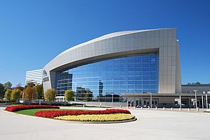
The Cobb Galleria Centre is a meeting and convention center in the Cumberland/Galleria district of Cobb County, northwest of Atlanta, Georgia, in the United States. It is also located next to a cluster of mid-rise office buildings, Cumberland Mall, Truist Park, The Battery Atlanta and the Cobb Energy Performing Arts Centre. It has hosted over 20,000 events and 10 million of guests.

Cumberland, Georgia
Unincorporated area in Georgia, United States
Distance: Approx. 2423 meters
Latitude and longitude: 33.8761,-84.4598
Cumberland is an edge city in Cobb County located in an unincorporated area of the northwest Atlanta metropolitan area, Georgia, United States. It is situated ten miles (16 km) northwest of downtown Atlanta. With approximately 122,000 workers and 103,000 residents, Cumberland is the region's fifth-largest business district, and is marked by several modern skyscrapers rising from the wooded hills above the freeways.

Cobb Galleria
Distance: Approx. 1493 meters
Latitude and longitude: 33.88416,-84.466277
Cobb Galleria is a large office park with six skyscrapers located in the Cumberland/Vinings district of Cobb County in the U.S. state of Georgia. Its location is sandwiched between Marietta, Smyrna, Sandy Springs and the City of Atlanta. It is near many hotels and parks, the Cumberland Mall (accessible by a pedestrian bridge), the Cobb Galleria Centre, the Cobb Energy Performing Arts Center and the intersections of Interstate 75 and Interstate 285.
Cobb Energy Performing Arts Centre
Concert hall in Atlanta, Georgia
Distance: Approx. 1640 meters
Latitude and longitude: 33.883803,-84.458063
Cobb Energy Performing Arts Centre is a performing arts venue located in the Cumberland/Galleria edge city, in northwest Atlanta, Georgia, United States. The $145 million facility celebrated its grand opening September 15, 2007, with a concert by Michael Feinstein and Linda Eder. Located in Cobb County near Vinings, the venue is owned and operated by the Cobb-Marietta Coliseum & Exhibit Hall Authority, and took over two years to build.
Georgia Public Policy Foundation
American free market public policy think tank
Distance: Approx. 1977 meters
Latitude and longitude: 33.8812,-84.4561
The Georgia Public Policy Foundation (GPPF) is a free market public policy think tank based in Atlanta, Georgia. The president and CEO is Kyle Wingfield. The organization's board of directors currently includes eight individuals.

Riverbend Apartments
Complex known in the 1970s for its singles scene
Distance: Approx. 1450 meters
Latitude and longitude: 33.897359,-84.448909
Riverbend Apartments was an infamous 600-unit apartment complex located in suburban Atlanta, Georgia, off Interstate 285. It has been described as Atlanta's most notorious singles complex. The apartment complex was also the plot setting for part of the 2002 film Catch Me If You Can.
JordanCon
Fan convention dedicated to Robert Jordan's The Wheel of Time
Distance: Approx. 1223 meters
Latitude and longitude: 33.9025,-84.47638889
JordanCon is a North American convention held annually in Atlanta, Georgia, that celebrates Robert Jordan's fantasy book series The Wheel of Time, as well as other science fiction and fantasy works. The convention is a 501c4 tax exempt charitable organization founded in honor of the late Robert Jordan.

Akers Mill
Distance: Approx. 1613 meters
Latitude and longitude: 33.88641389,-84.45336667
Akers Mill was a complex of at least two 19th-century mills along Rottenwood Creek in Cobb County, Georgia, United States. The gristmill built into the bank overlooking the creek, with six terraces each acting as an individual floor in the mill operation. The mills developed shortly before the Civil War, were sold to the Akers family in 1873 and in turn were utilized for the production of flour and meal for their Atlanta area grocery stores.

Truist Park
Baseball park in Metro Atlanta, Georgia
Distance: Approx. 892 meters
Latitude and longitude: 33.89,-84.468
Truist Park is a baseball stadium in the Atlanta metropolitan area, approximately 10 miles (16 km) northwest of downtown Atlanta in the unincorporated community of Cumberland, in Cobb County, Georgia. Opened in 2017, it is the ballpark of Major League Baseball's Atlanta Braves. Previously named SunTrust Park, the ballpark was renamed after SunTrust Bank became Truist Financial in 2020.

The Battery Atlanta
Mixed-use development near Truist Park in Cobb County, Georgia
Distance: Approx. 1305 meters
Latitude and longitude: 33.88722222,-84.47138889
The Battery Atlanta is a mixed-use development located in the Atlanta metropolitan area, approximately 10 miles (16 km) northwest of downtown Atlanta in the unincorporated community of Cumberland, in Cobb County, Georgia. It is adjacent to Truist Park (originally SunTrust Park), home of the Atlanta Braves. The complex is a mix of shops, dining, living and workspace in the area surrounding the ballpark.

Coca-Cola Roxy
Concert venue in Cumberland, Georgia, US
Distance: Approx. 939 meters
Latitude and longitude: 33.8902,-84.4697
The Coca-Cola Roxy is a concert venue located in The Battery Atlanta in Cumberland, Georgia. Named after the old Roxy Theatre, the venue opened in April 2017.
Weather in this IP's area
broken clouds
14 Celsius
14 Celsius
13 Celsius
16 Celsius
1015 hPa
86 %
1015 hPa
982 hPa
10000 meters
0.45 m/s
0.89 m/s
115 degree
75 %
07:13:38
17:32:58

