199.115.75.159 - IP Lookup: Free IP Address Lookup, Postal Code Lookup, IP Location Lookup, IP ASN, Public IP
Country:
Region:
City:
Location:
Time Zone:
Postal Code:
IP information under different IP Channel
ip-api
Country
Region
City
ASN
Time Zone
ISP
Blacklist
Proxy
Latitude
Longitude
Postal
Route
Luminati
Country
ASN
Time Zone
America/Chicago
ISP
G-Core Labs S.A.
Latitude
Longitude
Postal
IPinfo
Country
Region
City
ASN
Time Zone
ISP
Blacklist
Proxy
Latitude
Longitude
Postal
Route
IP2Location
199.115.75.159Country
Region
ontario
City
toronto
Time Zone
America/Toronto
ISP
Language
User-Agent
Latitude
Longitude
Postal
db-ip
Country
Region
City
ASN
Time Zone
ISP
Blacklist
Proxy
Latitude
Longitude
Postal
Route
ipdata
Country
Region
City
ASN
Time Zone
ISP
Blacklist
Proxy
Latitude
Longitude
Postal
Route
Popular places and events near this IP address

Greenwood station (Toronto)
Toronto subway station
Distance: Approx. 511 meters
Latitude and longitude: 43.6825,-79.33027778
Greenwood is a subway station on the Line 2 Bloor–Danforth in Toronto, Ontario, Canada. It is located at the southwest corner of Linnsmore Crescent and Strathmore Boulevard just north of Danforth Avenue. The entrance, collector's booth and bus bays are at street level, with stairs and escalators to a lower concourse level which provides a passage between the platforms on the level below.

Coxwell station
Toronto subway station
Distance: Approx. 132 meters
Latitude and longitude: 43.68416667,-79.32305556
Coxwell is a subway station on the Line 2 Bloor–Danforth in Toronto, Ontario, Canada. The station is located on Strathmore Boulevard just east of Coxwell Avenue and one block north of Danforth Avenue. It opened in 1966 as part of the original segment of the Bloor–Danforth line.

Beaches—East York (federal electoral district)
Federal electoral district in Ontario, Canada
Distance: Approx. 666 meters
Latitude and longitude: 43.685,-79.31611111
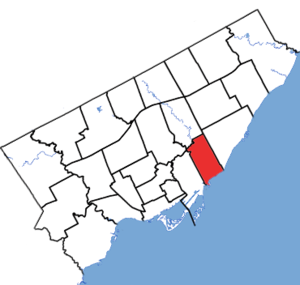
Beaches—East York (formerly Beaches—Woodbine) is a federal electoral district in Toronto, Ontario, Canada, that has been represented in the House of Commons of Canada since 1988. This riding is situated east of Toronto's downtown. According to the 2016 census, Beaches—East York has a population of 109,468 and is not known for its ethnic diversity compared to other ridings in Toronto.
Greenwood Yard
Distance: Approx. 879 meters
Latitude and longitude: 43.67777778,-79.33194444
The Greenwood Yard (also known as the Greenwood Complex) is a rail yard with support buildings that service subway vehicles on Line 2 Bloor–Danforth of the Toronto subway. Greenwood is one of two subway yards on Line 2, the other being the much smaller Keele Subway Yard.
Danforth Collegiate and Technical Institute
High school in Toronto, Ontario, Canada
Distance: Approx. 829 meters
Latitude and longitude: 43.682759,-79.334274
Danforth Collegiate and Technical Institute (known as Danforth CTI, DCTI, or Danforth), formerly Danforth Technical School and Riverdale Branch Technical School is a secondary school in Toronto, Ontario, Canada. It is located to the east of the city's Greek neighbourhood and between the Greenwood and Donlands subway stations. As the name suggests, it is set up as a technical school, with trades training and special shops for auto repair, carpentry etc.
Monarch Park Stadium
Distance: Approx. 429 meters
Latitude and longitude: 43.67944444,-79.32277778
Monarch Park Stadium is a multi-purpose stadium in Toronto, Ontario, Canada. It is located near the intersection of Hanson Street and Coxwell Avenue next to Monarch Park Collegiate. Monarch Park Stadium is used mostly for amateur soccer, baseball, and athletics principally by the Toronto District School Board.
Monarch Park Collegiate Institute
Public high school in East Danforth, Toronto, Ontario, Canada
Distance: Approx. 429 meters
Latitude and longitude: 43.67944444,-79.32277778
Monarch Park Collegiate (referred to as MPC, Monarch Park or Monarch; formerly known as Monarch Park Secondary School) is a high school located near the intersection of Coxwell Avenue and Danforth Avenue in Toronto, Ontario. It is a part of the Toronto District School Board.

Beaches—East York (provincial electoral district)
Provincial electoral district in Ontario, Canada
Distance: Approx. 477 meters
Latitude and longitude: 43.68444444,-79.31833333
Beaches—East York is a provincial riding in Toronto, Ontario, Canada. It elects one member to the Legislative Assembly of Ontario. It was created in 1996 from parts of Beaches—Woodbine (95%), Don Mills (40%), and York East (20%).

St. Patrick Catholic Secondary School
Catholic high school in Toronto, Canada
Distance: Approx. 662 meters
Latitude and longitude: 43.678151,-79.328343
St. Patrick Catholic Secondary School (also referred to as SPCSS, St. Pats, St.
Michael Garron Hospital
Hospital in Toronto, Ontario, Canada
Distance: Approx. 747 meters
Latitude and longitude: 43.6898,-79.3257
Michael Garron Hospital (MGH), formerly Toronto East General Hospital (TEGH), is a community teaching hospital located at 825 Coxwell Avenue in East York, Toronto, Ontario, Canada.

Lakeview Secondary School
Public high school in East Danforth, Toronto, Ontario, Canada
Distance: Approx. 662 meters
Latitude and longitude: 43.678,-79.328
Lakeview Secondary School (LSS, Lakeview), formerly East End High School is a Toronto District School Board public and vocational high school facility that was formerly operated as a secondary school by the Toronto Board of Education from 1967 until 1989 located in Felstad Drive in Toronto, Ontario, Canada serving the Board's Ward 15. Founded in 1967, the current building was built in 1972.
Roxy Theatre (Toronto)
Theatre in Toronto, Ontario, Canada
Distance: Approx. 646 meters
Latitude and longitude: 43.68145,-79.33165
Roxy Theatre was the final name of a theatre that operated from 1935 to 2006 at 1215 Danforth Avenue, in Toronto, Ontario, Canada's east end. It was designed by the architectural firm Kaplan & Sprachman, which designed dozens of neighbourhood cinemas, and opened under the name Allenby Theatre. In the 1930s the Allenby allowed neighbourhood children to enroll in the Popeye Club, where they could watch a double bill, and two episodes of the popeye cartoon serials, for ten cents.
Weather in this IP's area
overcast clouds
1 Celsius
-0 Celsius
0 Celsius
2 Celsius
1025 hPa
88 %
1025 hPa
1012 hPa
10000 meters
1.54 m/s
310 degree
100 %


