199.114.249.114 - IP Lookup: Free IP Address Lookup, Postal Code Lookup, IP Location Lookup, IP ASN, Public IP
Country:
Region:
City:
Location:
Time Zone:
Postal Code:
IP information under different IP Channel
ip-api
Country
Region
City
ASN
Time Zone
ISP
Blacklist
Proxy
Latitude
Longitude
Postal
Route
Luminati
Country
ASN
Time Zone
America/Chicago
ISP
CISN2
Latitude
Longitude
Postal
IPinfo
Country
Region
City
ASN
Time Zone
ISP
Blacklist
Proxy
Latitude
Longitude
Postal
Route
IP2Location
199.114.249.114Country
Region
massachusetts
City
woburn
Time Zone
America/New_York
ISP
Language
User-Agent
Latitude
Longitude
Postal
db-ip
Country
Region
City
ASN
Time Zone
ISP
Blacklist
Proxy
Latitude
Longitude
Postal
Route
ipdata
Country
Region
City
ASN
Time Zone
ISP
Blacklist
Proxy
Latitude
Longitude
Postal
Route
Popular places and events near this IP address
Woburn, Massachusetts
City in Massachusetts, United States
Distance: Approx. 719 meters
Latitude and longitude: 42.47916667,-71.15277778
Woburn ( WOO-bərn) is a city in Middlesex County, Massachusetts, United States. The population was 40,876 at the 2020 census. Woburn is located 9 miles (14 km) north of Boston.
Benjamin Thompson House–Count Rumford Birthplace
Historic house in Massachusetts, United States
Distance: Approx. 1013 meters
Latitude and longitude: 42.47916667,-71.14722222
The Benjamin Thompson House (also known as the Count Rumford Birthplace) is a historic house museum and National Historic Landmark at 90 Elm Street, in the North Woburn area of Woburn, Massachusetts. It is significant as the birthplace of scientist and inventor Benjamin Thompson (1753–1814), who became Count Rumford of the Holy Roman Empire as well as Sir Benjamin Thompson of the United Kingdom. His birthplace was designated a National Historic Landmark in 1975 in recognition of Rumford's scientific accomplishments, which notably include the development of the Rumford fireplace, a fireplace design that was significantly more efficient at retaining heat in the house than older and larger fireplaces.
1790 House
Historic house in Massachusetts, United States
Distance: Approx. 1993 meters
Latitude and longitude: 42.50277778,-71.15805556
The 1790 House, also called the Joseph Bartlett House or the Bartlett–Wheeler House, is a historic house located at 827 Main Street, Woburn, Massachusetts, and listed on the National Register of Historic Places. It is close to the Baldwin House, with the Middlesex Canal running between them. The 1790 House, originally on Main Street, has been moved closer to the canal to make room for a hotel.
Baldwin House (Woburn, Massachusetts)
Historic house in Massachusetts, United States
Distance: Approx. 1931 meters
Latitude and longitude: 42.50222222,-71.15805556
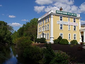
The Baldwin House, also known as the Loammi Baldwin Mansion, is a Colonial American mansion located in Woburn, Massachusetts. On October 7, 1971, it was added to the National Register of Historic Places. It is currently a restaurant called Sichuan Garden.

Woburn Memorial High School
Public high school in Woburn, Massachusetts, United States
Distance: Approx. 1105 meters
Latitude and longitude: 42.48313889,-71.14355556
Woburn Memorial High School (WMHS) is a public high school in Woburn, Massachusetts, United States. It is part of the Woburn Public Schools district and participates in the Middlesex League. It is home to the Tanners and Tannerettes and the nickname "Tanners" has a historical context.
Winn Memorial Library
United States historic place
Distance: Approx. 685 meters
Latitude and longitude: 42.47888889,-71.155
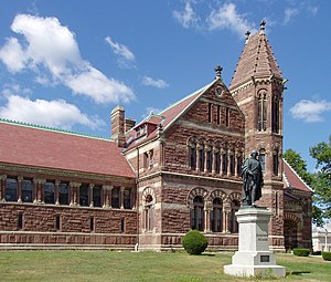
Woburn Public Library, previously known as the Winn Memorial Library (1876–79) is a National Historic Landmark in Woburn, Massachusetts. Designed by architect H. H. Richardson, the Romanesque Revival building was a bequest of the Winn family. It houses the Woburn Public Library, an institution that was established in 1856.

First Burial Ground (Woburn, Massachusetts)
Historic site in Middlesex County, Massachusetts
Distance: Approx. 473 meters
Latitude and longitude: 42.48166667,-71.15305556
The First Burial Ground or Park Street Burial Ground is a historic cemetery on Park Street near Centre Street in Woburn, Massachusetts. Established c. 1646, it is the city's first and oldest cemetery.
Lechmere Warehouse station
Distance: Approx. 2133 meters
Latitude and longitude: 42.49312,-71.13333
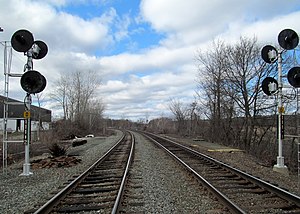
Lechmere Warehouse was a railroad stop in Woburn, Massachusetts. It served the Lowell Line of the MBTA Commuter Rail system. The station, located in northwestern Woburn away from the residential areas, primarily served reverse commuters working at the adjacent warehouse of the Lechmere department store.

Horn Pond (Massachusetts)
Pond in Woburn, Massachusetts
Distance: Approx. 1690 meters
Latitude and longitude: 42.46972222,-71.15641667
Horn Pond is a 102-acre (41 ha) water body along the Aberjona River in Woburn, Massachusetts in the United States. The pond is fed by several brooks and flows out via Horn Pond Brook to the Aberjona River and the Mystic Lakes, eventually reaching the Mystic River and the Atlantic Ocean. It was also traversed by the Middlesex Canal from 1802 to 1860.

Woburn station
Railroad station in Woburn, Massachusetts
Distance: Approx. 751 meters
Latitude and longitude: 42.47885,-71.152748
Woburn station was a railroad station on the Woburn Branch (formerly the Woburn Loop), part of the Massachusetts Bay Transportation Authority's Lowell Line.
First Church of Woburn
Historic church in Massachusetts, United States
Distance: Approx. 784 meters
Latitude and longitude: 42.47861111,-71.1525
The First Church of Woburn, formerly the First Congregational Church in Woburn, is a historic nondenominational Christian church at 322 Main Street in Woburn, Massachusetts. The congregation, established in 1642, is one of the oldest in the United States, and its church building (the sixth for the congregation) is a local landmark. The Italianate-style church was built in 1860, and its 196-foot (60 m) steeple is believed to be the tallest wooden steeple in North America.
Cross Street station (MBTA)
Former train station in Winchester, Massachusetts, US
Distance: Approx. 2334 meters
Latitude and longitude: 42.4659,-71.14477
Cross Street station was an MBTA Commuter Rail station in northern Winchester, Massachusetts, on the border with Woburn. The station first opened in the mid-1840s as Richardson Row on the Woburn Branch Railroad, part of the Boston and Lowell Railroad (B&L). It was renamed Cross Street in 1876.
Weather in this IP's area
clear sky
8 Celsius
6 Celsius
5 Celsius
11 Celsius
1013 hPa
86 %
1013 hPa
1010 hPa
10000 meters
3.6 m/s
170 degree


