Country:
Region:
City:
Latitude and Longitude:
Time Zone:
Postal Code:
IP information under different IP Channel
ip-api
Country
Region
City
ASN
Time Zone
ISP
Blacklist
Proxy
Latitude
Longitude
Postal
Route
Luminati
Country
ASN
Time Zone
America/Chicago
ISP
AS19174
Latitude
Longitude
Postal
IPinfo
Country
Region
City
ASN
Time Zone
ISP
Blacklist
Proxy
Latitude
Longitude
Postal
Route
db-ip
Country
Region
City
ASN
Time Zone
ISP
Blacklist
Proxy
Latitude
Longitude
Postal
Route
ipdata
Country
Region
City
ASN
Time Zone
ISP
Blacklist
Proxy
Latitude
Longitude
Postal
Route
Popular places and events near this IP address
Los Angeles Community College District
Community college district in Los Angeles, California, United States
Distance: Approx. 172 meters
Latitude and longitude: 34.0491,-118.2578
The Los Angeles Community College District (LACCD) is the community college district serving Los Angeles, California, and some of its neighboring cities and certain unincorporated areas of Los Angeles County. Its headquarters are in Downtown Los Angeles. Over the past seventy-seven years, LACCD has served as educator to more than three million students.

Aon Center (Los Angeles)
Modernist office skyscraper at 707 Wilshire Boulevard in downtown Los Angeles, California
Distance: Approx. 101 meters
Latitude and longitude: 34.049167,-118.256944
Aon Center is a 62-story, 858 ft (262 m) Modernist office skyscraper at 707 Wilshire Boulevard in downtown Los Angeles, California. Site excavation started in late 1970, and the tower was completed in 1973. Designed by Charles Luckman, the rectangular bronze-clad building with white trim is remarkably slender for a skyscraper in a seismically active area.

611 Place
Skyscraper in Los Angeles, California, United States
Distance: Approx. 52 meters
Latitude and longitude: 34.04905,-118.255619
611 Place (displayed as AT&T CENTER) is a 42-story, 189 m (620 ft) skyscraper at 611 West 6th Street in Downtown Los Angeles, California, designed by William L. Pereira & Associates and completed in 1969. The building was commissioned by the now-defunct Crocker Citizen's Bank, and served as its Southern California headquarters until 1983, when it moved to Crocker Center, now Wells Fargo Center (Los Angeles). It was subsequently bought by AT&T. It was the tallest building in Los Angeles upon completion, and the first building to surpass Los Angeles City Hall in terms of structural height (many buildings had surpassed City Hall with decorative spires, the first being Richfield Tower).
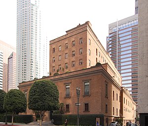
California Club
United States historic place
Distance: Approx. 180 meters
Latitude and longitude: 34.05027778,-118.25641667
The California Club is an invitation-only private club established in 1888, based in Los Angeles, California. According to the Los Angeles Times, "The people who run Los Angeles belong to the Jonathan Club; the people who own Los Angeles belong to the California Club." The California Club maintains a mandatory requirement that all new member candidates wishing to gain entry must receive invitations from no less than six existing club members, pass a series of interviews by the club's membership committee, and undergo additional background and reference checks in order to obtain admission. In April 2005, the club was ranked #13 in the "Centrality Rankings" by UC Santa Cruz sociologist G. William Domhoff in his research about social clubs, policy-planning groups, corporations, and ruling-class cohesiveness.
Superior Oil Company Building
United States historic place
Distance: Approx. 176 meters
Latitude and longitude: 34.05027778,-118.25611111
The Delphi Hotel is a 12-story hotel located at 550 S Flower St in Downtown Los Angeles in the marble-clad high-rise Superior Oil Company Building formerly the headquarters of the now defunct company, converted to The Standard Downtown LA hotel in 2002, then closed in 2020 and reopened in 2023 under its current name.
General Petroleum Building
United States historic place
Distance: Approx. 184 meters
Latitude and longitude: 34.04944444,-118.25777778
The General Petroleum Building, also known as the Mobil Oil Building and the Pegasus Apartments, is a highrise building in the Modern architecture style located in Downtown Los Angeles.

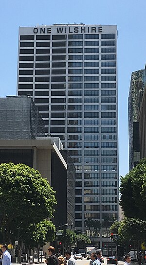
One Wilshire
Office building in Los Angeles, US
Distance: Approx. 96 meters
Latitude and longitude: 34.0479,-118.2556
One Wilshire is an office building located at the junction of Wilshire Boulevard and South Grand Avenue in downtown Los Angeles, California, United States. Located at the easterly end of Wilshire, its address is 624 S. Grand Avenue. Built in 1966, the thirty story high-rise was designed by Skidmore, Owings and Merrill, and for its first decades in existence it was used almost exclusively by law firms.

First Interstate Tower fire
1988 fire in Los Angeles, California
Distance: Approx. 120 meters
Latitude and longitude: 34.04922222,-118.25713889
The First Interstate Tower fire was a high-rise fire that occurred on May 4, 1988, at the First Interstate Tower (now Aon Center) in Los Angeles, California, a 62-story, 860 foot (260 m) skyscraper, then the tallest building in the city. The fire destroyed five floors of the building, injured 40 people, and caused the death of a maintenance worker, when the elevator he was riding opened onto the burning 12th floor.
Brockman Building
United States historic place
Distance: Approx. 197 meters
Latitude and longitude: 34.04696389,-118.25642778
The Brockman Building is a 12-story Beaux-Arts, Classical, and Romanesque Revival style building located on 7th Street in Downtown Los Angeles.

Los Angeles Central Library
Main branch of the Los Angeles Public Library
Distance: Approx. 198 meters
Latitude and longitude: 34.05027778,-118.255
Richard J. Riordan Central Library, primarily known as the Los Angeles Central Library, is the main branch of the Los Angeles Public Library (LAPL), in Downtown Los Angeles. It is named after Mayor of Los Angeles Richard Riordan, although locals refer to the library as Central Library and not by this name. It consists of two buildings: the Goodhue Building and the Tom Bradley addition, from 1925 and 1993, respectively.
Q Sushi
Restaurant in Los Angeles, California, U.S.
Distance: Approx. 171 meters
Latitude and longitude: 34.04716667,-118.25608333
Q Sushi is a sushi restaurant in Los Angeles, California.
Los Angeles Homeless Services Authority
American county agency
Distance: Approx. 110 meters
Latitude and longitude: 34.04921465,-118.25702005
Los Angeles Homeless Services Authority (LAHSA) is the lead agency responsible for coordinating housing and social services for the homeless in Los Angeles County. LAHSA allocates funds and administers contracts with regional agencies that provide emergency, transitional and permanent housing, and other services that assist homeless individuals. In the 2022-2023 fiscal year, LAHSA had an annual budget of US$845,367,023 (equivalent to $880,166,075 in 2023).
Weather in this IP's area
clear sky
13 Celsius
12 Celsius
10 Celsius
16 Celsius
1020 hPa
29 %
1020 hPa
1011 hPa
10000 meters
06:19:38
16:54:05


