Country:
Region:
City:
Latitude and Longitude:
Time Zone:
Postal Code:
IP information under different IP Channel
ip-api
Country
Region
City
ASN
Time Zone
ISP
Blacklist
Proxy
Latitude
Longitude
Postal
Route
Luminati
Country
Region
ia
City
dubuque
ASN
Time Zone
America/Chicago
ISP
IMONC
Latitude
Longitude
Postal
IPinfo
Country
Region
City
ASN
Time Zone
ISP
Blacklist
Proxy
Latitude
Longitude
Postal
Route
db-ip
Country
Region
City
ASN
Time Zone
ISP
Blacklist
Proxy
Latitude
Longitude
Postal
Route
ipdata
Country
Region
City
ASN
Time Zone
ISP
Blacklist
Proxy
Latitude
Longitude
Postal
Route
Popular places and events near this IP address

Dubuque, Iowa
City in Iowa, United States
Distance: Approx. 1622 meters
Latitude and longitude: 42.5,-90.69
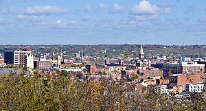
Dubuque ( , dəb-YOOK) is a city in and the county seat of Dubuque County, Iowa, United States, located along the Mississippi River. At the time of the 2020 census, the population of Dubuque was 59,667. The city lies at the junction of Iowa, Illinois, and Wisconsin, a region locally known as the Tri-State Area.

Loras College
Private university in Dubuque, Iowa, US
Distance: Approx. 1494 meters
Latitude and longitude: 42.505,-90.68
Loras College is a private Catholic college in Dubuque, Iowa. It has an enrollment of approximately 1,600 students and is the oldest post-secondary institution in the state of Iowa. The school offers both undergraduate and graduate degree programs.
Clarke University
Catholic university in Dubuque, Iowa, US
Distance: Approx. 517 meters
Latitude and longitude: 42.51,-90.691
Clarke University is a private Catholic university in Dubuque, Iowa. It was founded in 1843 as St. Mary's Female Academy by Mother Mary Frances Clarke, foundress of the Sisters of Charity of the Blessed Virgin Mary.
Wahlert Catholic High School
Private secondary school in Dubuque, Iowa, United States
Distance: Approx. 1084 meters
Latitude and longitude: 42.51888889,-90.70472222
Wahlert Catholic High School is a private Roman Catholic high school in Dubuque, Iowa, United States, in the Roman Catholic Archdiocese of Dubuque.

Holy Ghost Catholic Church (Dubuque, Iowa)
Historic district in Iowa, United States
Distance: Approx. 1534 meters
Latitude and longitude: 42.52388889,-90.67944444
Holy Ghost Catholic Church is a Catholic parish located within the city of Dubuque, Iowa, United States. It is part of the Archdiocese of Dubuque. The church, school, rectory, and convent were listed together as a historic district on the National Register of Historic Places in 2011.

Emmaus University
Distance: Approx. 1224 meters
Latitude and longitude: 42.509,-90.706
Emmaus University (formerly Emmaus Bible College) is a private Bible college in Dubuque, Iowa, affiliated with the Plymouth Brethren. It offers double majors in both professional and biblical studies. It was established as Emmaus Bible School in 1941 in Toronto, Ontario, by Ed Harlow, John Smart, and Ernest Tatham.

Dubuque Senior High School
Public secondary school in Dubuque, Iowa, United States
Distance: Approx. 939 meters
Latitude and longitude: 42.506,-90.694
Dubuque Senior High School (commonly Senior or DSHS) is a four-year public high school located in Dubuque, Iowa. It is one of two high schools in the Dubuque Community School District, and enrolls 1,447 students in grades 9–12. The school's mascot is the Ram; it competes at the state level in class 4A (which contains the state's largest schools) and is a member of the Mississippi Valley Athletic Conference.
Dubuque Community School District
Public school district in Dubuque, Iowa, United States
Distance: Approx. 1009 meters
Latitude and longitude: 42.511268,-90.704544
The Dubuque Community School District (DCSD) is a public school district based in Dubuque, Iowa, United States. DCSD, which operates schools in eastern Dubuque County, is the seventh largest school district in Iowa. As of the 2021-2022 school year, DCSD has 10,535 students enrolled in its schools.
Holy Family Catholic Schools
Distance: Approx. 1139 meters
Latitude and longitude: 42.518,-90.706
Holy Family Catholic Schools (HFCS) is a Roman Catholic school system based in Dubuque, Iowa (USA). Holy Family, which operates schools in eastern Dubuque County, is a part of the Roman Catholic Archdiocese of Dubuque. As of the 2011–2012 school year, HFCS has 1,837 students enrolled in its schools (excluding preschools).
KLYV
Radio station in Iowa, United States
Distance: Approx. 1712 meters
Latitude and longitude: 42.503,-90.707
KLYV (105.3 FM) is a radio station broadcasting a top 40 (CHR) format branded as Y105, serving the Dubuque, Iowa, United States, area. The station is owned by Townsquare Media and licensed to Townsquare License, LLC. The station has been a "typical" Top 40 station since 1982, and a CHR station since 1986. The station first went under the formats of MOR in the 1970s, and beautiful music beginning in 1980.

Ora Holland House
Historic house in Iowa, United States
Distance: Approx. 1703 meters
Latitude and longitude: 42.50044444,-90.6845
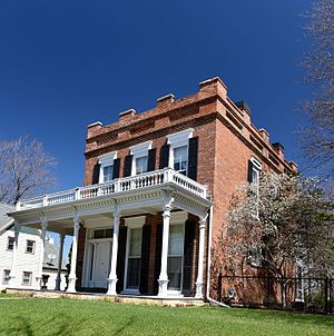
The Ora Holland House, also known as the Holland-Viner House, is a historic building located in Dubuque, Iowa, United States. Holland was a contractor-builder who came to Dubuque from Vermont in 1846 by way of Jacksonville, Illinois where he learned his trade. He built his house over a period of two years because of other projects he was involved with, completing construction in 1857.

Ice hockey in Iowa
Distance: Approx. 1622 meters
Latitude and longitude: 42.5,-90.69
Iowa has become one of the key regions for junior ice hockey in the United States.
Weather in this IP's area
moderate rain
7 Celsius
5 Celsius
7 Celsius
8 Celsius
1010 hPa
73 %
1010 hPa
980 hPa
2816 meters
2.57 m/s
30 degree
100 %
06:52:12
16:42:16