198.91.2.219 - IP Lookup: Free IP Address Lookup, Postal Code Lookup, IP Location Lookup, IP ASN, Public IP
Country:
Region:
City:
Location:
Time Zone:
Postal Code:
ISP:
ASN:
language:
User-Agent:
Proxy IP:
Blacklist:
IP information under different IP Channel
ip-api
Country
Region
City
ASN
Time Zone
ISP
Blacklist
Proxy
Latitude
Longitude
Postal
Route
db-ip
Country
Region
City
ASN
Time Zone
ISP
Blacklist
Proxy
Latitude
Longitude
Postal
Route
IPinfo
Country
Region
City
ASN
Time Zone
ISP
Blacklist
Proxy
Latitude
Longitude
Postal
Route
IP2Location
198.91.2.219Country
Region
michigan
City
ann arbor
Time Zone
America/Detroit
ISP
Language
User-Agent
Latitude
Longitude
Postal
ipdata
Country
Region
City
ASN
Time Zone
ISP
Blacklist
Proxy
Latitude
Longitude
Postal
Route
Popular places and events near this IP address
Pittsfield Charter Township, Michigan
Charter township in Michigan, United States
Distance: Approx. 1812 meters
Latitude and longitude: 42.2225,-83.71444444
Pittsfield Charter Township is a charter township of Washtenaw County in the U.S. state of Michigan. The population was 39,147 at the 2020 census.
Ann Arbor Municipal Airport
Airport in City of Ann Arbor
Distance: Approx. 2646 meters
Latitude and longitude: 42.22305556,-83.74555556
Ann Arbor Municipal Airport (IATA: ARB, ICAO: KARB, FAA LID: ARB) is a general aviation airport in Washtenaw County, Michigan, United States. It is included in the Federal Aviation Administration (FAA) National Plan of Integrated Airport Systems for 2017 to 2021, in which it is categorized as a regional general aviation facility. The airport is located in Pittsfield Township, but is owned and operated by the City of Ann Arbor.

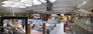
Briarwood Mall
Shopping mall in Michigan, United States
Distance: Approx. 2141 meters
Latitude and longitude: 42.2405,-83.74647222
Briarwood Mall is a shopping mall in Ann Arbor, Michigan, United States. The mall's three anchor stores are Macy's, JCPenney, and Von Maur. Surrounded by office and other development, the mall anchors the southern Ann Arbor commercial area around Eisenhower Boulevard and I-94.
Clonlara School
School in Ann Arbor, Michigan, United States
Distance: Approx. 1994 meters
Latitude and longitude: 42.25422222,-83.73125
Clonlara School is private alternative school located in Ann Arbor, Michigan, United States.
Buhr Park
Park in Michigan, United States of America
Distance: Approx. 1329 meters
Latitude and longitude: 42.24745,-83.710664
Buhr Park is a 39-acre public park in Ann Arbor, Michigan. There is a large public swimming pool and a smaller children's wading pool with interactive toys. Buhr Park also includes 39 acres (160,000 m2) of rolling hills, picnic areas with barbecue grills, a children's play area, softball diamonds, soccer fields and outdoor tennis courts.
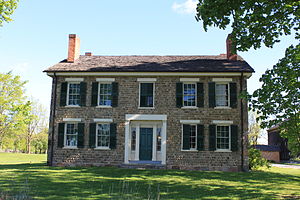
Cobblestone Farm and Museum
Historic house in Michigan, United States
Distance: Approx. 1135 meters
Latitude and longitude: 42.245,-83.71055556
The Cobblestone Farm and Museum, which includes the Dr. Benajah Ticknor House (also known as the Ticknor-Campbell House) is an historical museum located at 2781 Packard Road in Ann Arbor Michigan. The museum gets its name from the cobblestone used to build the farmhouse.
Ann Arbor Learning Community
Distance: Approx. 1319 meters
Latitude and longitude: 42.23144444,-83.73394444
Ann Arbor Learning Community (AALC) is a K-12 public charter school in Ann Arbor, Michigan, authorized by Eastern Michigan University. Enrollment is open to all K-12 students residing within the state of Michigan. Because AALC is part of the public school system, tuition is not charged to any student desiring to attend. .
Tuomy Hills Service Station
United States historic place
Distance: Approx. 2477 meters
Latitude and longitude: 42.25944444,-83.71222222
The Tuomy Hills Service Station is a commercial building located 2460 Washtenaw Avenue in Ann Arbor, Michigan. It was listed on the National Register of Historic Places in 2000.

County Farm Park
Public park in eastern Ann Arbor, Michigan
Distance: Approx. 2303 meters
Latitude and longitude: 42.255713,-83.706036
Nelson Meade County Farm Park is a 141-acre public park in eastern Ann Arbor, Michigan owned by Washtenaw County and operated by the county's Parks and Recreation Commission. Consisting of a mix of woodlands, fields, and gardens, the park is home to a wide variety of flora and fauna and is a popular local destination for gardening, hiking, jogging, and biking. The park has been county land since 1836, although for the majority of the nineteenth and twentieth centuries it was used as the county's poorhouse (complete with a working farm) and then as its infirmary.
William Anderson House
United States historic place
Distance: Approx. 1854 meters
Latitude and longitude: 42.25444444,-83.725
The William Anderson House is a single-family house located at 2301 Packard Street in Ann Arbor, Michigan. It was listed on the National Register of Historic Places in 1983. Built around 1853 for William Anderson, the first Washtenaw County Sheriff, the house is a well-preserved surviving example of Greek Revival architecture in Southeast Michigan.
Stone School (Ann Arbor, Michigan)
United States historic place
Distance: Approx. 990 meters
Latitude and longitude: 42.24694444,-83.71944444
The Stone School is a school building located at 2600 Packard Road in Ann Arbor, Michigan. It was listed on the National Register of Historic Places in 1995. Beginning in 1955, the building houses the Stone School Cooperative Nursery.

Genesis of Ann Arbor
Distance: Approx. 1872 meters
Latitude and longitude: 42.2547,-83.7243
Genesis of Ann Arbor is a house of worship in Ann Arbor, Michigan, home to two congregations: an Episcopal church and a Reform Jewish synagogue. Genesis of Ann Arbor was formed in 1974 as an equal partnership of the St. Clare of Assisi Episcopal Church and Temple Beth Emeth, which were founded in 1953 and 1970 respectively.
Weather in this IP's area
broken clouds
-3 Celsius
-9 Celsius
-4 Celsius
-3 Celsius
1027 hPa
70 %
1027 hPa
993 hPa
10000 meters
4.63 m/s
290 degree
75 %


