Country:
Region:
City:
Latitude and Longitude:
Time Zone:
Postal Code:
IP information under different IP Channel
ip-api
Country
Region
City
ASN
Time Zone
ISP
Blacklist
Proxy
Latitude
Longitude
Postal
Route
Luminati
Country
Region
fl
City
thevillages
ASN
Time Zone
America/New_York
ISP
ORLANDOTELCO
Latitude
Longitude
Postal
IPinfo
Country
Region
City
ASN
Time Zone
ISP
Blacklist
Proxy
Latitude
Longitude
Postal
Route
db-ip
Country
Region
City
ASN
Time Zone
ISP
Blacklist
Proxy
Latitude
Longitude
Postal
Route
ipdata
Country
Region
City
ASN
Time Zone
ISP
Blacklist
Proxy
Latitude
Longitude
Postal
Route
Popular places and events near this IP address

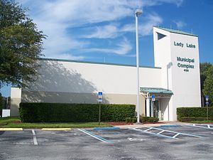
Lady Lake, Florida
Town in the state of Florida, United States
Distance: Approx. 5070 meters
Latitude and longitude: 28.92416667,-81.93
Lady Lake is a town in Lake County, Florida, United States. It is part of the Orlando–Kissimmee–Sanford Metropolitan Statistical Area. Area history is exhibited at the Lady Lake Historical Society Museum.

The Villages, Florida
Census-designated place in Florida, United States
Distance: Approx. 2758 meters
Latitude and longitude: 28.90333333,-81.98861111
The Villages is a census-designated place (CDP) in Sumter and Marion counties in the U.S. state of Florida. It shares its name with a broader master-planned, age-restricted community that spreads into portions of Lake County. The overall development lies in central Florida, approximately 20 miles (32 km) south of Ocala and approximately 45 miles (72 km) northwest of Orlando.

Wildwood, Florida
City in Florida, United States
Distance: Approx. 9444 meters
Latitude and longitude: 28.85861111,-82.03861111
Wildwood is a city in Sumter County, Florida, United States. The population was 15,730 at the 2020 census.

Weirsdale, Florida
Town in Florida, U.S.
Distance: Approx. 8241 meters
Latitude and longitude: 28.9817,-81.9244
Weirsdale is a town in Marion County, Florida, United States. It is located near the intersection of State Road 25 and State Road 42. The community is part of the Ocala Metropolitan Statistical Area.

Holy Trinity Episcopal Church (Fruitland Park, Florida)
Historic church in Florida, United States
Distance: Approx. 8442 meters
Latitude and longitude: 28.87722222,-81.91694444
Holy Trinity Episcopal Church, a historic Carpenter Gothic church located at 2201 Spring Lake Road, in Fruitland Park, Florida, is listed on the U.S. National Register of Historic Places.
WVLG
Radio station in Wildwood, Florida
Distance: Approx. 8112 meters
Latitude and longitude: 28.85527778,-81.97
WVLG (640 kHz) is a commercial AM radio station licensed to Wildwood, Florida, and serving The Villages. It is owned by Village Communications and airs a full service classic hits radio format. World and national news is provided by Fox News Radio.

Wildwood station
Distance: Approx. 8893 meters
Latitude and longitude: 28.86553,-82.03963
Wildwood station is a bus station, and former train station, in Wildwood, Florida. It serves Amtrak Thruway buses and formerly served trains for Amtrak and other rail companies. The station is located on 601 North Main Street (US 301) in Wildwood, Florida.

Oxford, Florida
Unincorporated community in Florida, United States
Distance: Approx. 5390 meters
Latitude and longitude: 28.9275,-82.03722222
Oxford is an unincorporated community in Sumter County, Florida, United States. Its ZIP code is 34484.

Lady Lake Historical Society Museum
American museum
Distance: Approx. 5940 meters
Latitude and longitude: 28.91574,-81.92241
Lady Lake Historical Society Museum is a local history museum in Lady Lake, Lake County, Florida. Exhibits include citrus industry artifacts, a miniature HO gauge railroad, furniture, tools, photographs, and memorabilia. The museum is located behind a log cabin on Lady Lake Boulevard.
Wildwood Middle High School
Public school in Wildwood, Florida, United States
Distance: Approx. 9230 meters
Latitude and longitude: 28.8572,-82.0323
Wildwood Middle High School is located in Wildwood, Florida. The school is the 6-12 school for the Sumter District Schools.

Conant, Florida
Ghost Town in Florida, United States
Distance: Approx. 5359 meters
Latitude and longitude: 28.93833333,-81.92833333
Conant is a ghost town in Lake County, Florida stretching from the area of Lady Lake, Florida to north of the Marion County, Florida line. It was established in 1884 on what was then the Florida Southern Railroad, and it was named for Sherman Conant. It was a "real estate town" developed by the Hollingshead Firm.
Weather in this IP's area
overcast clouds
24 Celsius
25 Celsius
23 Celsius
25 Celsius
1015 hPa
96 %
1015 hPa
1013 hPa
10000 meters
1.79 m/s
4.47 m/s
46 degree
100 %
06:44:29
17:38:41