198.71.77.168 - IP Lookup: Free IP Address Lookup, Postal Code Lookup, IP Location Lookup, IP ASN, Public IP
Country:
Region:
City:
Location:
Time Zone:
Postal Code:
ISP:
ASN:
language:
User-Agent:
Proxy IP:
Blacklist:
IP information under different IP Channel
ip-api
Country
Region
City
ASN
Time Zone
ISP
Blacklist
Proxy
Latitude
Longitude
Postal
Route
db-ip
Country
Region
City
ASN
Time Zone
ISP
Blacklist
Proxy
Latitude
Longitude
Postal
Route
IPinfo
Country
Region
City
ASN
Time Zone
ISP
Blacklist
Proxy
Latitude
Longitude
Postal
Route
IP2Location
198.71.77.168Country
Region
mississippi
City
hattiesburg
Time Zone
America/Chicago
ISP
Language
User-Agent
Latitude
Longitude
Postal
ipdata
Country
Region
City
ASN
Time Zone
ISP
Blacklist
Proxy
Latitude
Longitude
Postal
Route
Popular places and events near this IP address

Forrest County, Mississippi
County in Mississippi, United States
Distance: Approx. 6926 meters
Latitude and longitude: 31.19,-89.26
Forrest County is a county located in the U.S. state of Mississippi. As of the 2020 census, the population was 78,158. Its county seat and largest city is Hattiesburg.

Hattiesburg, Mississippi
City in Mississippi, United States
Distance: Approx. 7878 meters
Latitude and longitude: 31.31583333,-89.30861111
Hattiesburg is the 4th most populous city in the U.S. state of Mississippi, located primarily in Forrest County (where it is the county seat and most populous city) and extending west into Lamar County. The city population was 45,989 at the 2010 census, with the population now being 48,730 in 2020. Hattiesburg is the principal city of the Hattiesburg Metropolitan Statistical Area, which encompasses Covington, Forrest, Lamar, and Perry counties.
William Carey University
Christian university in Hattiesburg, Mississippi, US
Distance: Approx. 6345 meters
Latitude and longitude: 31.3062,-89.29116
William Carey University (Carey, William Carey, or WCU) is a private Christian university in Mississippi, affiliated with the Southern Baptist Convention and the Mississippi Baptist Convention. The main campus is in Hattiesburg and a second campus is in the Tradition community north of Biloxi. William Carey University was founded by W. I. Thames in 1892 as Pearl River Boarding School in Poplarville, Mississippi.
Forrest County Multipurpose Center
Distance: Approx. 756 meters
Latitude and longitude: 31.257387,-89.27625
The James Lynn Cartlidge Forrest County Multipurpose Center is an arena and county fairgrounds complex located in Hattiesburg, Mississippi. It consists of many buildings including a 120,000-square-foot (11,000 m2) main arena, a covered warm-up arena, and a conference center with 3,360 square feet (312 m2) of floor space. It is used for sporting events, concerts, trade shows, meetings and other special events.
Sacred Heart Catholic School (Hattiesburg, Mississippi)
Private school in Hattiesburg, , Mississippi, United States
Distance: Approx. 8209 meters
Latitude and longitude: 31.32277778,-89.29416667
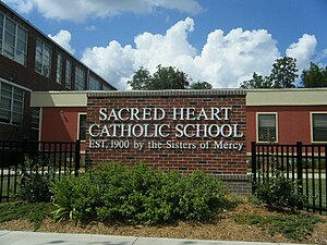
Sacred Heart Catholic School is a Roman Catholic parochial school in the historic district of downtown Hattiesburg, Mississippi where it is mostly surrounded by Victorian-era homes and other churches. It is the only PK-12 school in Northern Deanery of the Roman Catholic Diocese of Biloxi. Sacred Heart Catholic High School was officially detached from the elementary school on June 8, 2010 when the Hattiesburg City Council voted to accept a bid of $2.5 million for the city-owned property formerly known as First Baptist Church.

Beverly Drive-In Theatre
United States historic place
Distance: Approx. 3278 meters
Latitude and longitude: 31.27843889,-89.28771944
Beverly Drive-In Theatre opened May 29, 1948, as a cinema structure in Forrest County, Mississippi. It was operated continuously by the original owners until 1987, then reopened in 2001 under new management. Following substantial damage to the infrastructure by Hurricane Katrina in 2005, the Beverly Drive-In never recovered.

Hattiesburg Bobby L. Chain Municipal Airport
Airport in Forrest County, Mississippi
Distance: Approx. 2769 meters
Latitude and longitude: 31.265,-89.25277778
Hattiesburg Bobby L. Chain Municipal Airport (IATA: HBG, ICAO: KHBG, FAA LID: HBG) in Forrest County, Mississippi is owned by the City of Hattiesburg and is five miles southeast of downtown. The National Plan of Integrated Airport Systems for 2011–2015 called it a general aviation facility. There is no scheduled airline service; Hattiesburg–Laurel Regional Airport has commercial airline service.

Mississippi Armed Forces Museum
American military history museum
Distance: Approx. 7689 meters
Latitude and longitude: 31.19831,-89.22372
The Mississippi Armed Forces Museum is located at Camp Shelby, approximately 12 miles (19 km) south of Hattiesburg, Mississippi. The Armed Forces Museum serves as the military history museum for the State of Mississippi. It is a member of the Army Museum System.
Presbyterian Christian School
School in Hattiesburg, Forrest County, Mississippi, United States
Distance: Approx. 5096 meters
Latitude and longitude: 31.2851,-89.3117
Presbyterian Christian School (PCS), is a private Christian school in Hattiesburg, Mississippi. It was originally founded as Bay Street Christian Day School in 1976. It serves preschool through grade 12.

Building 6981, Camp Shelby
United States historic place
Distance: Approx. 7657 meters
Latitude and longitude: 31.1982,-89.22439
Building 6981 is a historic ammunition magazine located at Camp Shelby, Mississippi. Constructed in 1917, it is the only building at Camp Shelby still standing from the WWI era. The building was placed on the National Register of Historic Places in 1992 and was designated a Mississippi Landmark in 1995.

Walthall School (Hattiesburg, Mississippi)
United States historic place
Distance: Approx. 7669 meters
Latitude and longitude: 31.31878,-89.28808
Walthall School, also known as Court Street School, is located at 601 Court Street in Hattiesburg, Mississippi. It was utilized as a public school building from 1902 until 1987. The building is a contributing property to the Hattiesburg Historic Neighborhood District, which was placed on the National Register of Historic Places in 1980.

Eaton Elementary School (Hattiesburg, Mississippi)
United States historic place
Distance: Approx. 8154 meters
Latitude and longitude: 31.323758,-89.280672
Eaton Elementary School, also known as Third Ward School, is located at 1105 McInnis Ave. in Hattiesburg, Mississippi, United States. It was utilized as a public school building from 1905 until the late 1980s.
Weather in this IP's area
snow
-2 Celsius
-8 Celsius
-3 Celsius
-2 Celsius
1035 hPa
54 %
1035 hPa
1025 hPa
10000 meters
4.63 m/s
9.77 m/s
30 degree
100 %
