198.62.203.23 - IP Lookup: Free IP Address Lookup, Postal Code Lookup, IP Location Lookup, IP ASN, Public IP
Country:
Region:
City:
Location:
Time Zone:
Postal Code:
IP information under different IP Channel
ip-api
Country
Region
City
ASN
Time Zone
ISP
Blacklist
Proxy
Latitude
Longitude
Postal
Route
Luminati
Country
ASN
Time Zone
America/Chicago
ISP
NGP-TELENETWORKS
Latitude
Longitude
Postal
IPinfo
Country
Region
City
ASN
Time Zone
ISP
Blacklist
Proxy
Latitude
Longitude
Postal
Route
IP2Location
198.62.203.23Country
Region
new york
City
spring valley
Time Zone
America/New_York
ISP
Language
User-Agent
Latitude
Longitude
Postal
db-ip
Country
Region
City
ASN
Time Zone
ISP
Blacklist
Proxy
Latitude
Longitude
Postal
Route
ipdata
Country
Region
City
ASN
Time Zone
ISP
Blacklist
Proxy
Latitude
Longitude
Postal
Route
Popular places and events near this IP address

Hillcrest, Rockland County, New York
Census-designated place in New York, United States
Distance: Approx. 1906 meters
Latitude and longitude: 41.12972222,-74.03555556
Hillcrest is a hamlet incorporated in 1893 and census-designated place, in the town of Ramapo, Rockland County, New York, United States. It is located north of Spring Valley, east of Viola, south of New Square and New Hempstead, and west of New City. The population was 8,164 at the 2020 census.

Kaser, New York
Village in New York, United States
Distance: Approx. 1572 meters
Latitude and longitude: 41.11666667,-74.06666667
Kaser (from Yiddish: כּתר, romanized: keser, lit. 'crown') is a village in the town of Ramapo, Rockland County, New York, United States. The village is completely surrounded by the hamlet of Monsey. As of the 2020 United States census, the village population was 5,491.

Monsey, New York
CDP in New York, United States
Distance: Approx. 1562 meters
Latitude and longitude: 41.11944444,-74.06583333
Monsey (, Yiddish: מאנסי, romanized: Monsi) is a hamlet and census-designated place in the town of Ramapo, Rockland County, New York, United States, north of Airmont, east of Viola, south of New Hempstead, and west of Spring Valley. The village of Kaser is surrounded by the hamlet of Monsey. The 2020 census listed the population at 26,954.

Spring Valley, New York
Village in Rockland County, New York, United States
Distance: Approx. 108 meters
Latitude and longitude: 41.11444444,-74.04777778
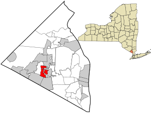
Spring Valley is a village in the town of Ramapo and Clarkstown in Rockland County, New York, United States. It is located north of Chestnut Ridge, east of Airmont and Monsey, south of Hillcrest, and west of Nanuet. The population was 33,066 at the 2020 census, making it the second most populous community in both Clarkstown and Rockland County, after New City.

Spring Valley station (New York)
NJ Transit and Metro-North Railroad station
Distance: Approx. 514 meters
Latitude and longitude: 41.1119,-74.044
Spring Valley station (sometimes referred as the Spring Valley Transit Center) is an intermodal transit station in Spring Valley, New York. It serves commuter trains as well as buses as the Spring Valley Bus Terminal. The buses that serve the Spring Valley Bus Terminal are Rockland Coaches (provided by Coach USA), Hudson Link, and Transport of Rockland.
Beth Medrash Elyon
Distance: Approx. 1805 meters
Latitude and longitude: 41.11402778,-74.06944444
Beth Medrash Elyon is a four-year, not-for-profit yeshiva in Monsey, New York.
East Ramapo Central School District
School district in Ramapo, New York, United States
Distance: Approx. 1341 meters
Latitude and longitude: 41.103384,-74.049121
East Ramapo Central School District is a school district in Ramapo, New York, United States. It is headquartered in the Senator Eugene Levy Dr. Jack R. Anderson Education Center.

St. Paul's Episcopal Church (Spring Valley, New York)
Historic church in New York, United States
Distance: Approx. 742 meters
Latitude and longitude: 41.108925,-74.04588611
St. Paul's Episcopal Church is a historic Episcopal church at 26 S. Madison Avenue in Spring Valley, Rockland County, New York. It was built in 1872 and is a frame Gothic Revival style parish church.

United States Post Office (Spring Valley, New York)
United States historic place
Distance: Approx. 357 meters
Latitude and longitude: 41.11277778,-74.04555556
The U.S. Post Office in Spring Valley, New York, is located on North Madison Street. It is a brick building from the mid-1930s that serves the ZIP Code 10977, covering the village of Spring Valley. Its Colonial Revival design, unique to Spring Valley among post offices in New York, emphasizes the Greek Revival precedents of the style.

North Main Street School
Historic school building in New York, US
Distance: Approx. 728 meters
Latitude and longitude: 41.12083333,-74.04316667
The North Main Street School is located on that street (also New York State Route 45) in Spring Valley, New York, United States. It is a brick Colonial Revival building erected in the early 20th century in response to a rapidly increasing school population. Several times since then, it has been expanded.
Spring Valley High School (New York)
School in Spring Valley, New York, United States
Distance: Approx. 1107 meters
Latitude and longitude: 41.10744,-74.05591
Spring Valley High School is a high school located in Spring Valley, New York, educating students in grades 9 through 12. Spring Valley is one of two high schools in the East Ramapo Central School District (ERCSD). The school is accredited by the New York State Board of Regents.

Monsey Church
Church in New York, United States
Distance: Approx. 1817 meters
Latitude and longitude: 41.112168,-74.069232
The Monsey Church is the colloquial name of a historic Reformed Christian church in the hamlet of Monsey, town of Ramapo, in southern Rockland County, New York, the official name of which, since December 6, 2000, is New Hope Christian Church. The church was founded in 1824 as the True Reformed Dutch Church of West New Hempstead and later became known as the Monsey Christian Reformed Church. The church owns a historic cemetery adjacent to the site of its first meeting house and briefly operated a private Christian school in the 1950s and '60s.
Weather in this IP's area
few clouds
-8 Celsius
-12 Celsius
-10 Celsius
-4 Celsius
1033 hPa
84 %
1033 hPa
1015 hPa
10000 meters
2.04 m/s
4.53 m/s
352 degree
12 %