Country:
Region:
City:
Latitude and Longitude:
Time Zone:
Postal Code:
IP information under different IP Channel
ip-api
Country
Region
City
ASN
Time Zone
ISP
Blacklist
Proxy
Latitude
Longitude
Postal
Route
Luminati
Country
ASN
Time Zone
America/Chicago
ISP
NOAA-NWAVE
Latitude
Longitude
Postal
IPinfo
Country
Region
City
ASN
Time Zone
ISP
Blacklist
Proxy
Latitude
Longitude
Postal
Route
db-ip
Country
Region
City
ASN
Time Zone
ISP
Blacklist
Proxy
Latitude
Longitude
Postal
Route
ipdata
Country
Region
City
ASN
Time Zone
ISP
Blacklist
Proxy
Latitude
Longitude
Postal
Route
Popular places and events near this IP address

Oscar Straus Memorial
Monument in Washington, D.C.
Distance: Approx. 70 meters
Latitude and longitude: 38.8938,-77.0316
The Oscar S. Straus Memorial in Washington, D.C., commemorates the accomplishments of the first Jew to serve in the cabinet of a U.S. president. Oscar Solomon Straus was Secretary of Commerce and Labor under President Theodore Roosevelt from 1906 to 1909. The memorial is a marble fountain located in the Federal Triangle on 14th Street between Pennsylvania Avenue and Constitution Avenue, Northwest, Washington, D.C. It is located in front of the Ronald Reagan Building and International Trade Center.

Ronald Reagan Building and International Trade Center
Federal building in Washington, D.C.
Distance: Approx. 136 meters
Latitude and longitude: 38.89388889,-77.03083333
The Ronald Reagan Building and International Trade Center, named after former United States President Ronald Reagan, is located in downtown Washington, D.C., and was the first federal building in Washington designed for both governmental and private sector purposes. Each of the organizations located in the Pennsylvania Avenue building are dedicated to international trade and global relations. Organizations headquartered in this building include U.S. Customs and Border Protection (CBP), U.S. Agency for International Development (USAID), and the Woodrow Wilson International Center for Scholars.

Woodrow Wilson International Center for Scholars
American think tank
Distance: Approx. 168 meters
Latitude and longitude: 38.8936,-77.0305
The Woodrow Wilson International Center for Scholars (WWICS) or Wilson Center is a Washington, D.C.–based think tank named for former U.S. President Woodrow Wilson. It is also a United States presidential memorial established as part of the Smithsonian Institution by an act of Congress in 1968. It self-identifies as nonpartisan.

National Aquarium (Washington, D.C.)
Former aquarium in Washington, D.C.
Distance: Approx. 48 meters
Latitude and longitude: 38.8936,-77.0328
The National Aquarium, Washington, D.C., was an aquarium in Washington D.C. It was located in the Herbert C. Hoover Building (owned by the General Services Administration), which is bounded by 14th Street NW on the east, 15th Street NW on the west, Pennsylvania Avenue NW on the north, and Constitution Avenue NW on the south. It was the first free and public aquarium in the United States. The National Aquarium in Washington, D.C. was smaller than its counterpart in Baltimore, Maryland — a facility also known as the National Aquarium, although independent until the two aquariums signed an alliance in 2003.

National Children's Museum
Children's museum in Washington, D.C.
Distance: Approx. 136 meters
Latitude and longitude: 38.89388889,-77.03083333
The National Children's Museum is a children's museum and science center in downtown Washington, D.C. It is intended to serve children up to age 12 and their families through interactive exhibits exploring science, technology, engineering, art, and math. Founded in 1974, the museum operated from 1979 to 2004 at 220 H Street, NE. It then operated as a "museum without walls" until 2009, when it opened a new location in National Harbor, Maryland. That closed in 2015.

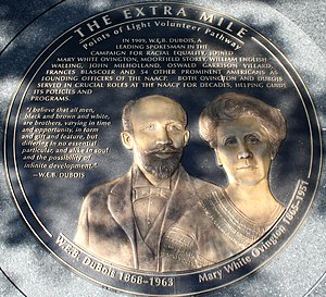
The Extra Mile
National monument in Washington D.C.
Distance: Approx. 206 meters
Latitude and longitude: 38.8955,-77.0336
The Extra Mile – Points of Light Volunteer Pathway is a memorial in Washington D.C. Located adjacent to the White House, the monument is composed of 34 bronze medallions honoring people who "through their caring and personal sacrifice, reached out to others, building their dreams into movements that helped people across America and throughout the world". The medallions, every 42 inches in diameter, are embedded in sidewalks that form a one-mile walking path bounded by Pennsylvania Avenue, 15th Street, G Street, and 11th Street, NW. Each medallion includes a bas-relief likeness of one or more honorees, a description of their achievement and a quotation. The Extra Mile was founded by John A. Johansen in 1992.

John A. Wilson Building
United States historic place
Distance: Approx. 151 meters
Latitude and longitude: 38.895,-77.03138889
The John A. Wilson District Building, popularly known simply as the Wilson Building, houses the municipal offices and chambers of the Mayor and the Council of Washington, D.C. It was originally called the District Building. In 1994, it was renamed in recognition of former Council Chair John A. Wilson. Completed in 1908, during the administration of 26th President Theodore Roosevelt, the building is a contributing structure to the Pennsylvania Avenue National Historic Site.
1977 Washington, D.C., attack and hostage taking
1977 siege
Distance: Approx. 151 meters
Latitude and longitude: 38.895,-77.03138889
The 1977 Hanafi Siege was a terrorist attack, hostage-taking, and standoff in Washington, D.C., lasting from March 9 to March 11, 1977. Three buildings (the District Building, B'nai B'rith headquarters, and Islamic Center of Washington) were seized by twelve Hanafi Movement gunmen, who took 149 hostages. During the initial attack and takeover of the buildings, the assailants killed a journalist and mortally wounded a police officer; three others, including a city councilor, were injured.

Herbert C. Hoover Building
United States historic place
Distance: Approx. 56 meters
Latitude and longitude: 38.8943,-77.0328
The Herbert C. Hoover Building is the Washington, D.C. headquarters of the United States Department of Commerce. The building is located at 1401 Constitution Avenue, Northwest, Washington, D.C., on the block bounded by Constitution Avenue NW to the south, Pennsylvania Avenue NW to the north, 15th Street NW to the west, and 14th Street NW to the east. It is located in the Federal Triangle, east of President's Park South (the Ellipse), north of the National Mall, and west of other Department of Commerce buildings, the John A. Wilson Building (District Building with the government of the District of Columbia / Washington, D.C.), and the Ronald Reagan Building.

U.S. Capitol Gatehouses and Gateposts
United States historic place
Distance: Approx. 215 meters
Latitude and longitude: 38.89236944,-77.03390556
The U.S. Capitol Gatehouses and Gateposts — designed circa 1827 by celebrated architect Charles Bulfinch — originally stood on the grounds of the United States Capitol in Washington, D.C. Two of the gatehouses are listed on the National Register of Historic Places in their new locations. One gatehouse and three of the gateposts now stand at 15th Street and Constitution Avenue within the President's Park South (PPS) historic district north of the National Mall.

Murder Bay
Destroyed and rebuilt slum neighborhood in Washington D.C., United States
Distance: Approx. 231 meters
Latitude and longitude: 38.893,-77.03
Murder Bay (also known as Hooker's Division) was a disreputable slum in Washington, D.C., roughly bounded by Constitution Avenue NW, Pennsylvania Avenue NW, and 13th and 15th Streets NW. The area was a center of crime through the early 20th century, with an extensive criminal underclass and prostitution occurring in several brothels and hotels in the area. The area was completely rebuilt during the construction of the Federal Triangle project in the late 1920s and 1930s.

Bearing Witness (sculpture)
1997 sculpture by Martin Puryear
Distance: Approx. 220 meters
Latitude and longitude: 38.893635,-77.029887
Bearing Witness is an outdoor 1997 sculpture by Martin Puryear, installed outside the Ronald Reagan Building and International Trade Center in Washington, D.C., in the United States. Twenty plus years after its construction the sculpture follows the characteristic style of Puryear and remains standing with minimal maintenance twenty plus years after its construction. The meaning of the sculpture is left up to interpretation, although many observers read into the inspirations Puryear may have had when designing the work.
Weather in this IP's area
few clouds
16 Celsius
15 Celsius
15 Celsius
17 Celsius
1016 hPa
50 %
1016 hPa
1015 hPa
10000 meters
5.66 m/s
11.32 m/s
310 degree
20 %
06:52:34
16:53:42
