Country:
 USA
USARegion:
City:
Latitude and Longitude:
Time Zone:
Postal Code:
IP information under different IP Channel
ip-api
Country
Region
City
ASN
Time Zone
ISP
Blacklist
Proxy
Latitude
Longitude
Postal
Route
IPinfo
Country
Region
City
ASN
Time Zone
ISP
Blacklist
Proxy
Latitude
Longitude
Postal
Route
MaxMind
Country
Region
City
ASN
Time Zone
ISP
Blacklist
Proxy
Latitude
Longitude
Postal
Route
Luminati
Country
USASN
Time Zone
America/Chicago
ISP
CENTURYLINK-LEGACY-SAVVIS
Latitude
Longitude
Postal
db-ip
Country
Region
City
ASN
Time Zone
ISP
Blacklist
Proxy
Latitude
Longitude
Postal
Route
ipdata
Country
Region
City
ASN
Time Zone
ISP
Blacklist
Proxy
Latitude
Longitude
Postal
Route
Popular places and events near this IP address

Wayland, Massachusetts
Town in Massachusetts, United States
Distance: Approx. 922 meters
Latitude and longitude: 42.3625,-71.36138889
Wayland is a town in Middlesex County, Massachusetts, United States. The town was founded in 1638, and incorporated in 1780 and was originally part of neighboring Sudbury (incorporated 1639). At the 2020 United States census, the population was 13,943.

Wayland High School
Massachusetts high school
Distance: Approx. 2467 meters
Latitude and longitude: 42.34144444,-71.37308333
Wayland High School is the public high school for the town of Wayland, Massachusetts, United States. During the 2022-2023 school year, there were 824 students enrolled at the high school. Wayland High School is consistently ranked as one of the best schools in the Boston area.

Old Connecticut Path
Native American trail
Distance: Approx. 2444 meters
Latitude and longitude: 42.35527778,-71.345
The Old Connecticut Path was the Native American trail that led westward from the area of Massachusetts Bay to the Connecticut River Valley, the first of the North American trails that led west from the settlements close to the Atlantic seacoast, towards the interior. The earliest colonists of Massachusetts Bay Colony used it, and rendered it wider by driving cattle along it. The old route is still followed, for part of its length, by Massachusetts Route 9 and Massachusetts Route 126.

Vokes Theatre
Distance: Approx. 2899 meters
Latitude and longitude: 42.35936111,-71.33772222
The Vokes Theatre, also known as Beatrice Herford's Vokes Theatre, is a 1904 miniature of a London theatre in Wayland, Massachusetts built by and named for Beatrice Herford. The theatre is located on the estate of Herford and her husband, Sidney Hayward.

Bogle-Walker House
Historic house in Massachusetts, United States
Distance: Approx. 2404 meters
Latitude and longitude: 42.365,-71.40166667
The Bogle-Walker House was a historic house in Sudbury, Massachusetts. The house, built c. 1806, was the centerpiece of a farm that remained in the same family's hands until the 1980s.
Wayland Center Historic District
Historic district in Massachusetts, United States
Distance: Approx. 1051 meters
Latitude and longitude: 42.36361111,-71.35972222
The Wayland Center Historic District encompasses the predominantly 19th-century village center of Wayland, Massachusetts. Located at the junction of United States Route 20 and Cochituate Road (Massachusetts Route 27), it includes fifteen well-preserved 19th-century buildings that form one of the best-preserved village centers of that period near Boston. It was added to the National Register of Historic Places in 1974.

Noyes-Parris House
Historic house in Massachusetts, United States
Distance: Approx. 1854 meters
Latitude and longitude: 42.34888889,-71.36194444
The Noyes-Parris House is a historic First Period house located in Wayland, Massachusetts.

Old Town Bridge (Wayland, Massachusetts)
United States historic place
Distance: Approx. 1449 meters
Latitude and longitude: 42.37527778,-71.38027778
The Old Town Bridge is a historic stone arch bridge in Wayland, Massachusetts. It is located just north of Old Sudbury Road, and is sited across what was formerly a channel of the Sudbury River, which now flows just west and north of the bridge. The four-arch bridge was built in 1848 by Josiah Russell on a site where it is supposed that the first bridge in Middlesex County was built in the 1640s.

Hopestill Bent Tavern
Historic tavern in Massachusetts, United States
Distance: Approx. 2447 meters
Latitude and longitude: 42.34166667,-71.37055556
The Hopestill Bent Tavern is a historic First Period tavern (now a private residence) in Wayland, Massachusetts, United States. The oldest portion of this 2+1⁄2-story building was built on this site c. 1710, and consisted of two rooms with a central chimney.
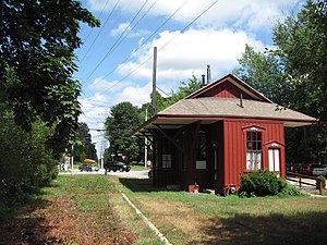
Wayland station
Former railroad station in Wayland, Massachusetts
Distance: Approx. 884 meters
Latitude and longitude: 42.364314,-71.36179
Wayland station is a former railroad station in Wayland, Massachusetts. Originally operated by the Central Massachusetts Railroad, it was later part of the Boston and Maine Railroad. The MBTA subsidized service at the station beginning in 1965.

Reeves Tavern
Historic building in Massachusetts, US
Distance: Approx. 2186 meters
Latitude and longitude: 42.35194444,-71.35111111
Reeves Tavern is a historic colonial tavern (now a private residence) in Wayland, Massachusetts. Built in 1762–63, it is one of the town's best preserved examples of an early tavern. It was listed on the National Register of Historic Places in 2016.

Islamic Center of Boston
Mosque in Wayland, Massachusetts
Distance: Approx. 2448 meters
Latitude and longitude: 42.3613,-71.3429
The Islamic Center of Boston (Wayland) is a mosque in Wayland, Massachusetts, U.S. It was established in 1979 in Cambridge, Massachusetts, and moved to Wayland in 1986. It hosts Friday Jummah Prayers, a Sunday school program, and Eid prayers. It is commonly referred to as ICB, as well as the center in official communications.
Weather in this IP's area
clear sky
11 Celsius
10 Celsius
10 Celsius
13 Celsius
1026 hPa
75 %
1026 hPa
1021 hPa
10000 meters
2.49 m/s
6.03 m/s
253 degree
07:04:33
17:55:30