Country:
Region:
City:
Latitude and Longitude:
Time Zone:
Postal Code:
IP information under different IP Channel
ip-api
Country
Region
City
ASN
Time Zone
ISP
Blacklist
Proxy
Latitude
Longitude
Postal
Route
Luminati
Country
ASN
Time Zone
Asia/Riyadh
ISP
ARAMCO-AS
Latitude
Longitude
Postal
IPinfo
Country
Region
City
ASN
Time Zone
ISP
Blacklist
Proxy
Latitude
Longitude
Postal
Route
db-ip
Country
Region
City
ASN
Time Zone
ISP
Blacklist
Proxy
Latitude
Longitude
Postal
Route
ipdata
Country
Region
City
ASN
Time Zone
ISP
Blacklist
Proxy
Latitude
Longitude
Postal
Route
Popular places and events near this IP address
Bellaire, Texas
Enclave city in Texas, United States
Distance: Approx. 2750 meters
Latitude and longitude: 29.70709444,-95.46738611
Bellaire is a city in southwestern Harris County, Texas, United States, within the Houston–Sugar Land–Baytown metropolitan area. As of the 2020 U.S. census, the city population was 17,202. It is surrounded by the cities of Houston and West University Place.

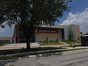
Bellaire High School (Texas)
Public secondary school in Bellaire, Texas, United States
Distance: Approx. 1334 meters
Latitude and longitude: 29.69111111,-95.46861111
Bellaire High School is a comprehensive, public secondary school in Bellaire, Texas. Part of the Houston Independent School District, it serves the incorporated city of Bellaire, the Houston community of Meyerland, and other adjacent Houston neighborhoods. It has a racially and socioeconomically diverse student body.

Pershing Middle School (Houston)
Middle school in Houston, Texas
Distance: Approx. 2686 meters
Latitude and longitude: 29.701641,-95.43878
John J. Pershing Middle School is a middle school in Houston, Texas, United States. It is located in the Braeswood Place neighborhood, near the Texas Medical Center. The school, that serves around 1,650 students in grades 6 through 8, is managed by the Houston Independent School District.
St. Thomas' Episcopal School
Independent school in Houston, Texas, United States
Distance: Approx. 704 meters
Latitude and longitude: 29.685158,-95.464732
Saint Thomas' Episcopal School (STE) is a private, co-ed Episcopal institution serving Pre-kindergarten through 12th grade. It is located in the Meyerland area of Houston, Texas. The school has 553 students and 111 faculty members.

Meyerland, Houston
Community in Houston, Texas
Distance: Approx. 956 meters
Latitude and longitude: 29.685,-95.4674
Meyerland is a community in southwest Houston, Texas, outside of the 610 Loop and inside Beltway 8. The neighborhood is named after the Meyer family, who bought and owned 6,000 acres (24 km2) of land in southwest Houston. Meyerland is the center of Houston's Jewish community; the Meyerland area is the home of Houston's Jewish Community Center, Congregation Beth Israel, Congregation Beth Yeshurun, and several smaller synagogues.

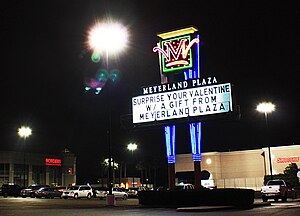
Meyerland Plaza
Shopping center in Houston, Texas
Distance: Approx. 548 meters
Latitude and longitude: 29.687,-95.462
Meyerland Plaza is a large shopping center located in southwest Houston, Texas, United States. Meyerland Plaza is located in the Meyerland neighborhood of Houston and is just outside the 610 Loop. The anchor stores are JCPenney, Target, Ross Dress for Less, Marshalls, EOS Fitness, H-E-B, Old Navy, Joann, and Office Depot.
Willowbend, Houston
Neighborhood in Houston, Texas
Distance: Approx. 2145 meters
Latitude and longitude: 29.6655,-95.451
Willowbend is a neighborhood in near Southwest Houston, Texas. Willowbend is just outside the 610 Loop and inside Beltway 8. The neighborhood is bound by the following streets: S. Post Oak Road to the West, Greenwillow Drive to the East, Briarbend Drive to the South, and Hazelton Street to North.
St. Catherine's Montessori School
Private school in Houston, Texas, United States
Distance: Approx. 2680 meters
Latitude and longitude: 29.675021,-95.431838
St. Catherine's Montessori is a Catholic Montessori School in Houston, Texas. St.

The Emery/Weiner School
Jewish day school in Houston, Texas, United States
Distance: Approx. 2094 meters
Latitude and longitude: 29.6752,-95.4384
The Emery/Weiner School (EWS) is a co-educational, independent Jewish day school in Houston, Texas, United States, serving grades 6-12. The school is accredited by the Independent Schools Association of the Southwest. The campus is located on 15 acres (61,000 m2) of land, in Link Valley, a community in southwest Houston outside of the 610 Loop, inside Beltway 8, and east of the Westwood subdivision.
Congregation Beth Yeshurun (Houston)
Synagogue
Distance: Approx. 683 meters
Latitude and longitude: 29.6887,-95.4532
Congregation Beth Yeshurun is a Conservative synagogue at 4525 Beechnut Street, Houston, Texas, in the United States. Founded in 1891 as Adath Yeshurun, it merged in Congregation Beth El in 1946, taking its current name. In 2002 Beth Yeshurun absorbed the membership of Shearith Israel of nearby Wharton, Texas.
Houston Graduate School of Theology
Multidenominational seminary
Distance: Approx. 1434 meters
Latitude and longitude: 29.6736,-95.4487
Houston Graduate School of Theology (HGST) is a private evangelical seminary in Houston, Texas. It is part of Kairos University.
Link Valley, Houston
Populated place in Texas
Distance: Approx. 2135 meters
Latitude and longitude: 29.677,-95.437
Link Valley is a community in southwestern Houston, Texas that consists of many apartment complexes. In the late 1980s it was nicknamed "Death Valley" due to high levels of drug-related and violent crime. Since a 1989 raid Link Valley has not had significant criminal activity.
Weather in this IP's area
clear sky
20 Celsius
20 Celsius
17 Celsius
21 Celsius
1013 hPa
76 %
1013 hPa
1011 hPa
10000 meters
2.57 m/s
360 degree
06:39:33
17:31:26


