Country:
 USA
USARegion:
City:
Latitude and Longitude:
Time Zone:
Postal Code:
IP information under different IP Channel
ip-api
Country
Region
City
ASN
Time Zone
ISP
Blacklist
Proxy
Latitude
Longitude
Postal
Route
IPinfo
Country
Region
City
ASN
Time Zone
ISP
Blacklist
Proxy
Latitude
Longitude
Postal
Route
MaxMind
Country
Region
City
ASN
Time Zone
ISP
Blacklist
Proxy
Latitude
Longitude
Postal
Route
Luminati
Country
USRegion
tx
City
houston
ASN
Time Zone
America/Chicago
ISP
PSLIGHTWAVE
Latitude
Longitude
Postal
db-ip
Country
Region
City
ASN
Time Zone
ISP
Blacklist
Proxy
Latitude
Longitude
Postal
Route
ipdata
Country
Region
City
ASN
Time Zone
ISP
Blacklist
Proxy
Latitude
Longitude
Postal
Route
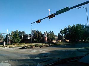
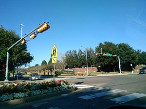
Popular places and events near this IP address

Stratford High School (Houston)
Public school in the United States
Distance: Approx. 3440 meters
Latitude and longitude: 29.77472222,-95.60416667
Stratford High School is a secondary school in Houston, Texas, United States. The school is one of four high schools in the Spring Branch Independent School District (SBISD), the district's westernmost secondary school (serving grades 9 through 12). Stratford High School serves several neighborhoods, including Westchester, Sherwood Oaks, Nottingham Forest, Nottingham West, Wilchester, Gaywood, Wilchester West, Yorkshire, Memorial Townhomes, Village on Memorial Townhomes, Memorial Way, Rustling Pines, Memorial Plaza, and the SBISD portions of Thornwood and Ashford Forest.
Terry Hershey Park
Distance: Approx. 2837 meters
Latitude and longitude: 29.767078,-95.618906
Terry Hershey Park is a county park that runs parallel to a roughly 6-mile (9.7 km) stretch of the Buffalo Bayou in western Houston, Texas. The park is named after Terry Hershey, a conservationist who campaigned to keep the banks of Buffalo Bayou from being paved. The park hosts a network of trails that run along the bayou from State Highway 6 to the Sam Houston Tollway and is a popular destination for local residents, runners, bicyclists and Geocachers.

The Village School (Houston)
Private, boarding school in Houston, Texas, United States
Distance: Approx. 1144 meters
Latitude and longitude: 29.746816,-95.61805
The Village School is a coeducational non-denominational college preparatory private school for grades Pre-K through high school in Houston, Texas.

Royal Oaks Country Club
Country club and subdivision in Texas, United States
Distance: Approx. 2831 meters
Latitude and longitude: 29.7271,-95.58471
Royal Oaks Country Club is a country club and subdivision in Houston, Texas, United States, in the Alief community. The country club is located at 2910 Royal Oaks Club Drive, 8 miles (13 km) west of The Galleria. Sunrise Colony Company developed Royal Oaks out of the former Andrau Airpark property.

Club Westside
Distance: Approx. 3121 meters
Latitude and longitude: 29.750173,-95.575229
Club Westside is a private tennis club in Houston, Texas. It was the former home (2001–2007) to the ATP Tour U.S. Men's Clay Court Championships. Its 5,240-seat Gallery Furniture Stadium was the home of the Houston Wranglers of World TeamTennis.
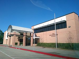
The Briarwood School (Houston, Texas)
Private school in Houston, Texas
Distance: Approx. 1125 meters
Latitude and longitude: 29.7472,-95.5957
The Briarwood School is a private school in Houston, Texas, in the Briar Forest community.

John Paul II Catholic School (Houston)
Private, co-ed school in Houston, United States, Texas, United States
Distance: Approx. 3267 meters
Latitude and longitude: 29.76166667,-95.63361111
Saint John Paul II Catholic School (commonly abbreviated to JPII) is a Catholic private school for grades Pre-K through 8th grade in western Houston, Texas. The school is within the Roman Catholic Archdiocese of Galveston-Houston. As of 2008 it serves over 700 students.
Temple Sinai (Houston)
Reform synagogue in Houston, Texas, US
Distance: Approx. 3058 meters
Latitude and longitude: 29.7615,-95.631
Temple Sinai is a Reform Jewish synagogue located 13875 Brimhurst Drive, in Houston, Texas, in the United States. Jewish residents on the west side of Houston and its western suburbs, including Katy, Cinco Ranch and Sugar Land worship at the synagogue. The congregation is composed of more than 200 families and is led by Rabbi David Lipper since 2022.
Lakes of Parkway, Houston
Community in Texas, United States
Distance: Approx. 2583 meters
Latitude and longitude: 29.748,-95.633
Lakes of Parkway is a gated community in western Houston, Texas, also the most southern community in the Energy Corridor. It has 888 lots. Peggy O'Hare of the Houston Chronicle stated in 2002 that the houses were "upscale".
Parkway Villages, Houston
Distance: Approx. 3320 meters
Latitude and longitude: 29.762,-95.634
Parkway Villages is a 577-lot, 224-acre (91 ha) subdivision in western Houston, Texas. It is located north of Lakes of Parkway, the former Barnhardt land tract. It was the first single family housing development by Sueba USA, a subsidiary of Süba Freie Baugesellschaft.
Houston Sudbury School
Distance: Approx. 3094 meters
Latitude and longitude: 29.7621,-95.6309
Houston Sudbury School (HSS) was a non-profit private Sudbury school in Spring Branch, Houston, Texas. The school served students of ages 6–18 and followed the Sudbury model of self-education. The democracy was meted out in a weekly school meeting where staff and students discussed and voted on a variety of administrative aspects of the school, including rules.
Alief Early College High School
Public school in Texas, United States
Distance: Approx. 3307 meters
Latitude and longitude: 29.7341,-95.5744
Alief Early College High School (AECHS) is a magnet high school in Houston, Texas and a part of the Alief Independent School District, in conjunction with Houston Community College. It was scheduled to open in fall 2009, and 120 spaces were to be available for ninth grade students. For the 2021-2022 school year, the school was given an "A" by the Texas Education Agency.
Weather in this IP's area
broken clouds
31 Celsius
38 Celsius
29 Celsius
33 Celsius
1010 hPa
72 %
1010 hPa
1007 hPa
10000 meters
6.69 m/s
160 degree
75 %
07:09:29
19:22:40