Country:
Region:
City:
Latitude and Longitude:
Time Zone:
Postal Code:
IP information under different IP Channel
ip-api
Country
Region
City
ASN
Time Zone
ISP
Blacklist
Proxy
Latitude
Longitude
Postal
Route
Luminati
Country
Region
tx
City
houston
ASN
Time Zone
America/Chicago
ISP
PSLIGHTWAVE
Latitude
Longitude
Postal
IPinfo
Country
Region
City
ASN
Time Zone
ISP
Blacklist
Proxy
Latitude
Longitude
Postal
Route
db-ip
Country
Region
City
ASN
Time Zone
ISP
Blacklist
Proxy
Latitude
Longitude
Postal
Route
ipdata
Country
Region
City
ASN
Time Zone
ISP
Blacklist
Proxy
Latitude
Longitude
Postal
Route
Popular places and events near this IP address

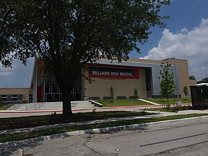
Bellaire High School (Texas)
Public secondary school in Bellaire, Texas, United States
Distance: Approx. 2459 meters
Latitude and longitude: 29.69111111,-95.46861111
Bellaire High School is a comprehensive, public secondary school in Bellaire, Texas. Part of the Houston Independent School District, it serves the incorporated city of Bellaire, the Houston community of Meyerland, and other adjacent Houston neighborhoods. It has a racially and socioeconomically diverse student body.
St. Thomas' Episcopal School
Independent school in Houston, Texas, United States
Distance: Approx. 2347 meters
Latitude and longitude: 29.685158,-95.464732
Saint Thomas' Episcopal School (STE) is a private, co-ed Episcopal institution serving Pre-kindergarten through 12th grade. It is located in the Meyerland area of Houston, Texas. The school has 553 students and 111 faculty members.

Meyerland, Houston
Community in Houston, Texas
Distance: Approx. 2115 meters
Latitude and longitude: 29.685,-95.4674
Meyerland is a community in southwest Houston, Texas, outside of the 610 Loop and inside Beltway 8. The neighborhood is named after the Meyer family, who bought and owned 6,000 acres (24 km2) of land in southwest Houston. Meyerland is the center of Houston's Jewish community; the Meyerland area is the home of Houston's Jewish Community Center, Congregation Beth Israel, Congregation Beth Yeshurun, and several smaller synagogues.

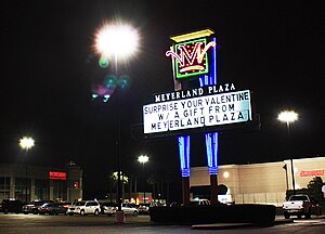
Meyerland Plaza
Shopping center in Houston, Texas
Distance: Approx. 2678 meters
Latitude and longitude: 29.687,-95.462
Meyerland Plaza is a large shopping center located in southwest Houston, Texas, United States. Meyerland Plaza is located in the Meyerland neighborhood of Houston and is just outside the 610 Loop. The anchor stores are JCPenney, Target, Ross Dress for Less, Marshalls, EOS Fitness, H-E-B, Old Navy, Joann, and Office Depot.
Maplewood, Houston
Community in Houston, Texas
Distance: Approx. 1278 meters
Latitude and longitude: 29.6824,-95.4961
Maplewood is a community in Houston, Texas located outside the 610 Loop, southwest of Downtown Houston. It consists of 524 houses. They are one-story and two-story houses, as two stories is the limit allowed by the subdivision.

Braeburn, Houston
Community of subdivisions in southwest Houston, Texas
Distance: Approx. 2387 meters
Latitude and longitude: 29.68,-95.51
Braeburn is a community of subdivisions in southwest Houston, Texas along Brays Bayou west of Hillcroft Avenue and south of the Sharpstown community. The first of these middle class subdivisions was developed after World War II at a time when the Richmond Farm-to-Market Road (later renamed as Bissonnet Street) provided the route into the city, rather than U.S. Highway 59. Development continued into the 1970s.

Westbury Christian School
School
Distance: Approx. 1221 meters
Latitude and longitude: 29.6676456,-95.495369
Westbury Christian School is a private, co-educational, K3 through 12th grade Christian school located in Houston, Texas, United States. Westbury Christian School is open to students of all faiths, nationalities, and ethnic origins.
Torah Day School of Houston
Distance: Approx. 2709 meters
Latitude and longitude: 29.661378,-95.509202
Torah Day School of Houston is a Jewish Day School in Houston established in 1977 by the Texas Regional Headquarters of the Chabad Lubavitch. It offers a Jewish education to grades K-8 in addition to its Early Childhood Center for children ages eighteen months through four years old.

Congregation Beth Israel (Houston)
Historic site in Harris County, Texas
Distance: Approx. 280 meters
Latitude and longitude: 29.6769,-95.4879
Congregation Beth Israel is a Reform Jewish congregation and synagogue located at 5600 North Braeswood Boulevard, in Houston, Texas, in the United States. The congregation, founded in 1854, is the oldest Jewish congregation in Texas; and it operates the Shlenker School.

Brays Oaks, Houston
Area in Southwest Houston, Texas, United States
Distance: Approx. 2150 meters
Latitude and longitude: 29.66,-95.5
Brays Oaks, formerly known as Fondren Southwest, is an area in Southwest Houston, Texas, United States. The Brays Oaks Management District, also known as the Harris County Improvement District #5, governs the Brays Oaks area as well as other surrounding areas, such as Westbury. The City of Houston also defines the Brays Oaks Super Neighborhood, with separate boundaries.
Robindell, Houston
Distance: Approx. 1679 meters
Latitude and longitude: 29.685,-95.499
Robindell is a subdivision in Southwest Houston, Texas.
Westbury Square
Past Texas shopping centre
Distance: Approx. 2074 meters
Latitude and longitude: 29.657227,-95.479584
Westbury Square was a shopping center located on a 7.5-acre (3.0 ha) site near the intersection of Chimney Rock Road and West Bellfort Avenue, in the Westbury neighborhood in the Brays Oaks district of Southwest Houston, Texas. It was built as a part of Westbury Section 3.
Weather in this IP's area
overcast clouds
23 Celsius
23 Celsius
22 Celsius
24 Celsius
1014 hPa
86 %
1014 hPa
1012 hPa
10000 meters
4.63 m/s
60 degree
100 %
06:42:05
17:29:39

