Country:
 USA
USARegion:
City:
Latitude and Longitude:
Time Zone:
Postal Code:
IP information under different IP Channel
ip-api
Country
Region
City
ASN
Time Zone
ISP
Blacklist
Proxy
Latitude
Longitude
Postal
Route
IPinfo
Country
Region
City
ASN
Time Zone
ISP
Blacklist
Proxy
Latitude
Longitude
Postal
Route
MaxMind
Country
Region
City
ASN
Time Zone
ISP
Blacklist
Proxy
Latitude
Longitude
Postal
Route
Luminati
Country
USRegion
tx
City
houston
ASN
Time Zone
America/Chicago
ISP
PSLIGHTWAVE
Latitude
Longitude
Postal
db-ip
Country
Region
City
ASN
Time Zone
ISP
Blacklist
Proxy
Latitude
Longitude
Postal
Route
ipdata
Country
Region
City
ASN
Time Zone
ISP
Blacklist
Proxy
Latitude
Longitude
Postal
Route
Popular places and events near this IP address

Jersey Village, Texas
City in Texas, United States
Distance: Approx. 3464 meters
Latitude and longitude: 29.89055556,-95.56861111
Jersey Village is a city in west-central Harris County, Texas, United States, located at U.S. Highway 290, Farm to Market Road 529, and the Southern Pacific Railroad. The city is located in the Houston–Sugar Land–Baytown metropolitan area. The population was 7,921 at the 2020 census.

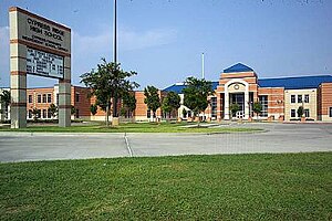
Jersey Village High School
Public high school in Houston, Texas, United States
Distance: Approx. 3535 meters
Latitude and longitude: 29.8822,-95.5557
Jersey Village High School is located in Jersey Village, Texas, United States, in the Houston metropolitan area. The school, which serves grades nine through twelve, is a part of the Cypress-Fairbanks ISD. Maggie Wiley serves as its principal, replacing previous Ralph Funk. Jersey Village High School serves the city of Jersey Village, small sections of Houston, and unincorporated sections of Harris County.

Bear Creek Pioneers Park
Distance: Approx. 5728 meters
Latitude and longitude: 29.824784,-95.6247
Bear Creek Pioneers Park is a 2,154-acre (8.72 km2) park located in the U.S. city of Houston, Texas, at 3535 War Memorial Drive.

The Parish School
School in Texas, United States
Distance: Approx. 5794 meters
Latitude and longitude: 29.811887,-95.571589
The Parish School is a private, non-profit school located in Houston, Texas, United States. It is adjacent to the Spring Branch district. The independent school serves children from developmentally 18 months to 12 years (or the fifth grade) who have average or above learning potential, but whose language, learning or communication differences impact their ability to be successful in a mainstream academic setting.
Cypress Ridge High School
Public school in Texas, United States
Distance: Approx. 3853 meters
Latitude and longitude: 29.8925,-95.6049
Cypress Ridge High School is a public secondary school located in unincorporated Harris County, Texas, near Houston. It was established in 2002 as Cypress-Fairbanks Independent School District High School #7. Cypress Ridge provides the deaf education program for Cy Fair ISD and surrounding school districts.
Houston Christian High School
School in Houston, Texas, United States
Distance: Approx. 5193 meters
Latitude and longitude: 29.8207,-95.5612
Houston Christian High School (HCHS) is a private, non-profit, coeducational, Christian day school which educates students in grades 9–12. HC is accredited by a member of the National Association of Independent Schools, and the Independent Schools Association of the Southwest. It is a 46 acres (19 ha) campus located in Spring Branch in western Houston, Texas, at the intersection of Beltway 8 and Kempwood Drive, inside Beltway 8 and outside Interstate 610.
Houston Ballet's Ben Stevenson Academy
Ballet school in Houston, Texas
Distance: Approx. 5563 meters
Latitude and longitude: 29.901196,-95.621352
Houston Ballet’s Ben Stevenson Academy is a ballet training school affiliated with the Houston Ballet. The academy is housed in Houston Ballet Center for Dance in Houston, Texas.
Satsuma, Texas
Unincorporated area in Texas, US
Distance: Approx. 4871 meters
Latitude and longitude: 29.90333333,-95.60333333
Satsuma (also Ashford and Thompson Switch) is an area in northern unincorporated Harris County, Texas, United States. Satsuma is located along U.S. Route 290, southeast of the community of Cypress and northwest of the city of Jersey Village. It was named for the groves of Satsuma mandarin oranges that were to be planted on site.
Fairbanks, Houston
Neighborhood of Houston, Texas, United States
Distance: Approx. 5709 meters
Latitude and longitude: 29.8527,-95.5266
Fairbanks is a community along U.S. Highway 290 and the Southern Pacific Railroad in Western Houston, Texas, United States. At one point it was a distinct unincorporated area within Harris County.
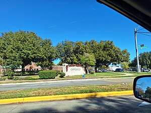
Copperfield, Texas
Distance: Approx. 6069 meters
Latitude and longitude: 29.8829,-95.643
Copperfield is a series of master-planned subdivisions in unincorporated northwestern Harris County, Texas, United States. The community, developed by Friendswood Development Company, has 1,800 acres (7.3 km2) of land. Horsepen Bayou and its tributaries are within the community.

Adventure Playground at the Parish School
Distance: Approx. 5839 meters
Latitude and longitude: 29.8114,-95.572
Adventure Play at the Parish School is an adventure playground located in Houston, Texas. The Adventure Playground at the Parish School consists of a three-acre play area open to children from 6 to 12 years old. It is one of the few junk playgrounds located in the United States, and the only one located in a school.
2020 Houston explosion
Industrial disaster in Houston, Texas in 2020
Distance: Approx. 4736 meters
Latitude and longitude: 29.8369,-95.5456
On January 24, 2020, a building at Watson Grinding and Manufacturing in northwest Houston, Texas, United States, exploded at 4:24 a.m. Debris was scattered as far as one-half mile (0.8 km), and approximately 200 nearby houses and businesses were damaged. Officials asked local residents to search for debris and body parts to assist with an investigation into the explosion's cause.
Weather in this IP's area
scattered clouds
31 Celsius
38 Celsius
29 Celsius
32 Celsius
1010 hPa
72 %
1010 hPa
1006 hPa
10000 meters
0.45 m/s
3.58 m/s
202 degree
38 %
07:09:22
19:22:36