198.32.233.28 - IP Lookup: Free IP Address Lookup, Postal Code Lookup, IP Location Lookup, IP ASN, Public IP
Country:
Region:
City:
Location:
Time Zone:
Postal Code:
ISP:
ASN:
language:
User-Agent:
Proxy IP:
Blacklist:
IP information under different IP Channel
ip-api
Country
Region
City
ASN
Time Zone
ISP
Blacklist
Proxy
Latitude
Longitude
Postal
Route
db-ip
Country
Region
City
ASN
Time Zone
ISP
Blacklist
Proxy
Latitude
Longitude
Postal
Route
IPinfo
Country
Region
City
ASN
Time Zone
ISP
Blacklist
Proxy
Latitude
Longitude
Postal
Route
IP2Location
198.32.233.28Country
Region
texas
City
west university place
Time Zone
America/Chicago
ISP
Language
User-Agent
Latitude
Longitude
Postal
ipdata
Country
Region
City
ASN
Time Zone
ISP
Blacklist
Proxy
Latitude
Longitude
Postal
Route
Popular places and events near this IP address
Southside Place, Texas
City in Texas, United States
Distance: Approx. 930 meters
Latitude and longitude: 29.70972222,-95.43555556
Southside Place is a city in west central Harris County, Texas, United States. The population was 1,835 at the 2020 census. As of the 2000 census, Southside Place is the 13th wealthiest location in Texas by per capita income.

West University Place, Texas
Enclave city in Texas, United States
Distance: Approx. 236 meters
Latitude and longitude: 29.71583333,-95.43305556
West University Place, often called West University or West U for short, is a city located in the U.S. state of Texas within the Houston–Sugar Land metropolitan area and southwestern Harris County. At the 2020 U.S. census, the population of the city was 14,955. It is nicknamed "The Neighborhood City" and is mainly a bedroom community for upper-class families.

Lakewood Church Central Campus
Formerly a sports arena and now the main facility of a megachurch in Houston, Texas, U.S.
Distance: Approx. 1385 meters
Latitude and longitude: 29.73027778,-95.435
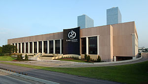
The Lakewood Church Central Campus is the main facility of Lakewood Church, a megachurch in Houston, Texas, five miles southwest of Downtown Houston and next to Greenway Plaza. From 1975 to 2003, the building served as a multi-purpose sports arena for professional teams, notably the NBA's Houston Rockets. It was known as The Summit until 1998, when technology firm Compaq bought naming rights and dubbed it Compaq Center.

Lakewood Church
Church in Texas, United States
Distance: Approx. 1349 meters
Latitude and longitude: 29.73,-95.43444444
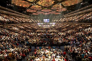
Lakewood Church is a non-denominational evangelical Christian megachurch located in Houston, Texas. It is among the largest congregations in the United States, averaging about 45,000 attendees per week. The 16,800-seat Lakewood Church building, home to four English-language services and two Spanish-language services per week, is located at the former Compaq Center.

Greenway Plaza
Business district of Houston in Texas, United States
Distance: Approx. 1657 meters
Latitude and longitude: 29.7327,-95.4318
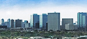
Greenway Plaza is a business district located along Interstate 69 (U.S. Highway 59) within the Interstate 610 loop in southwestern Houston, Texas, 5 miles (8.0 km) west of Downtown and 3 miles (4.8 km) east of Uptown. The district is located immediately west of Upper Kirby, north of West University Place, and south of River Oaks. First envisioned in the late 1960s by local developer Kenneth L. Schnitzer, Greenway Plaza has evolved into one of Greater Houston's largest employment centers, with over 4.4 million square feet (410,000 m2) of office space on a 52-acre (21-hectare) campus.

St. Mark's Episcopal School (West University Place, Texas)
School in Texas, United States
Distance: Approx. 1343 meters
Latitude and longitude: 29.70634,-95.437567
St. Mark's Episcopal School is a private primary and secondary school located in the Cambridge Place development and in West University Place, Texas, in Greater Houston. St.
Main Street Theater
Theatre company in Houston, Texas
Distance: Approx. 1523 meters
Latitude and longitude: 29.7168,-95.4179
Main Street Theater is a theatre company in the city of Houston, Texas. It consistently produces a repertoire of classic and contemporary plays, and its seasons generally run throughout the entire year.
Phoenix Tower (Houston)
Office in Houston, Texas
Distance: Approx. 1485 meters
Latitude and longitude: 29.7306,-95.4289
Phoenix Tower is a 434 ft (132m) tall skyscraper in Houston, Texas. It was completed in 1984 and has 34 floors. It is the 36th tallest building in the city.
Coastal Prairie Conservancy
Organization
Distance: Approx. 1533 meters
Latitude and longitude: 29.7221,-95.4185
Coastal Prairie Conservancy was established in 1992 to conserve Katy Prairie, part of the Western Gulf coastal grasslands located in Texas, United States. Approximately 24,500 acres is under conservation easements or owned by CPC in western Harris and Waller Counties.
Taipei Economic and Cultural Office in Houston
Political representative office in Houston, Texas
Distance: Approx. 1612 meters
Latitude and longitude: 29.732271,-95.435649
Taipei Economic and Cultural Office in Houston (TECO-Houston, Chinese: 駐休士頓台北經濟文化辦事處) represents the interests of Taiwan in the southern United States, functioning as a de facto consulate. The mission is located on the 20th Floor of 11 Greenway Plaza. It also oversees a Cultural Center at 10303 West Office Drive in the Westchase district of Houston.
Benjy's
Restaurant in Houston, Texas, U.S.
Distance: Approx. 1674 meters
Latitude and longitude: 29.7196,-95.4164
Benjy's is a restaurant serving American cuisine in Houston, in the U.S. state of Texas.

Lakewood Church shooting
February 11, 2024, shooting in Houston
Distance: Approx. 1285 meters
Latitude and longitude: 29.7294,-95.4348
On February 11, 2024, a shooting occurred at Lakewood Church in Houston, Texas, perpetrated by 36-year-old Genesse Moreno.
Weather in this IP's area
overcast clouds
16 Celsius
15 Celsius
15 Celsius
17 Celsius
1025 hPa
71 %
1025 hPa
1022 hPa
10000 meters
5.14 m/s
9.77 m/s
130 degree
100 %


