Country:
 USA
USARegion:
City:
Latitude and Longitude:
Time Zone:
Postal Code:
IP information under different IP Channel
ip-api
Country
Region
City
ASN
Time Zone
ISP
Blacklist
Proxy
Latitude
Longitude
Postal
Route
IPinfo
Country
Region
City
ASN
Time Zone
ISP
Blacklist
Proxy
Latitude
Longitude
Postal
Route
MaxMind
Country
Region
City
ASN
Time Zone
ISP
Blacklist
Proxy
Latitude
Longitude
Postal
Route
Luminati
Country
USRegion
ca
City
sanfrancisco
ASN
Time Zone
America/Los_Angeles
ISP
AS-SONICTELECOM
Latitude
Longitude
Postal
db-ip
Country
Region
City
ASN
Time Zone
ISP
Blacklist
Proxy
Latitude
Longitude
Postal
Route
ipdata
Country
Region
City
ASN
Time Zone
ISP
Blacklist
Proxy
Latitude
Longitude
Postal
Route
Popular places and events near this IP address

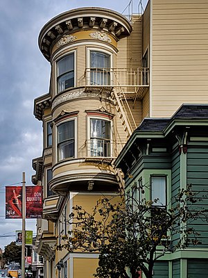
The Fillmore
Historic music venue in San Francisco, California
Distance: Approx. 242 meters
Latitude and longitude: 37.784098,-122.433132
The Fillmore is a historic music venue in San Francisco, California. Built in 1912 and originally named the Majestic Hall, it became the Fillmore Auditorium in 1954. It is in Western Addition, on the edge of the Fillmore District and Upper Fillmore neighborhood.

Winterland Ballroom
Former ice skating rink and music venue in San Francisco, California
Distance: Approx. 282 meters
Latitude and longitude: 37.78503611,-122.43488889
Winterland Ballroom (more commonly known as Winterland Arena or simply Winterland) was an ice skating rink and music venue in San Francisco, California, United States. The arena was located at the corner of Post Street and Steiner Street. It was converted for exclusive use as a music venue in 1971 by concert promoter Bill Graham and became a popular performance location for many rock acts.
Gateway High School (San Francisco)
School in San Francisco, California, United States
Distance: Approx. 233 meters
Latitude and longitude: 37.78316,-122.43751
Gateway High School is a charter school located in San Francisco, California. It was founded in September 1998. For many years it resided in the Sunset District at Laguna Honda before moving to its permanent location, at the corner of Geary and Scott, in the building that formerly housed Benjamin Franklin Middle School.
Jewish Community High School of the Bay
Private school in San Francisco, California, United States
Distance: Approx. 192 meters
Latitude and longitude: 37.78138889,-122.43666667
The Jewish Community High School of the Bay (commonly known as JCHS) is a coeducational, college preparatory high school located in the Western Addition Neighborhood of San Francisco, California. Founded in 2001, JCHS is a pluralistic Jewish high school.

St. Dominic's Catholic Church (San Francisco)
Distance: Approx. 497 meters
Latitude and longitude: 37.7868,-122.4365
St. Dominic's Catholic Church is a historic parish in the Lower Pacific Heights neighborhood of San Francisco, California, located at the corner of Bush and Steiner Streets. The parish was established by the Dominican Order in 1873, and the current church, built in the Gothic style, was finished in 1928.
Lower Pacific Heights, San Francisco
Place in California, USA
Distance: Approx. 494 meters
Latitude and longitude: 37.7868,-122.4364
Lower Pacific Heights, also known as Upper Fillmore, is a neighborhood in San Francisco, California, between Pacific Heights, the Fillmore District, Laurel Heights, and Japantown. The neighborhood is centered on the commercial corridor of Fillmore Street between California and Post streets, with California Street to the north, Geary Boulevard to the south, Presidio Avenue to the west, and Van Ness Avenue to the east.

Peoples Temple in San Francisco
Religious group's social and political activities base
Distance: Approx. 199 meters
Latitude and longitude: 37.7839,-122.4336
The Peoples Temple, the new religious movement which came to be known for the mass killings at Jonestown, was headquartered in San Francisco, California, United States from the early to mid-1970s until the Temple's move to Guyana in 1977. During this period, the Temple and its founder, Reverend Jim Jones, rose to national prominence thanks to Jones' interest in social and political causes, and wielded a significant amount of influence in San Francisco's city government.

AMC Kabuki 8
Building in California, USA
Distance: Approx. 329 meters
Latitude and longitude: 37.785,-122.433
AMC Kabuki 8 is a movie theater in the Japan Center complex in San Francisco's Japantown neighborhood.

Archbishop's Mansion
Historic house in San Francisco, built 1904
Distance: Approx. 477 meters
Latitude and longitude: 37.778316,-122.433824
Archbishop's Mansion is a historic house built in 1904 and located at 1000 Fulton Street in the Alamo Square neighborhood in San Francisco, California. The mansion was built for Patrick William Riordan, the second Roman Catholic Archbishop of San Francisco. The house is one of the 276 properties named as part of the "Alamo Square Historic District"; designated by the city of San Francisco in July 1984 (planning code, article 10).

Third Baptist Church (San Francisco, California)
Historic site in California, U.S.
Distance: Approx. 444 meters
Latitude and longitude: 37.778513,-122.434922
The Third Baptist Church, formerly the First Colored Baptist Church, is an American Baptist church founded in 1852, and located in the Western Addition neighborhood of San Francisco, California. It is the city of San Francisco's oldest African-American church. The church occupied several spaces in San Francisco over the course of its history.
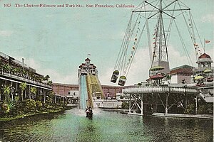
The Chutes of San Francisco
Amusement park in California, 1895- 1911
Distance: Approx. 404 meters
Latitude and longitude: 37.78,-122.43166667
The Chutes of San Francisco (also known as the Fillmore Chutes was an amusement park located on Fillmore Street, in the Fillmore District of San Francisco, California, bounded by Webster, Eddy and Turk Streets.
Avery (restaurant)
Restaurant in San Francisco, California, U.S.
Distance: Approx. 259 meters
Latitude and longitude: 37.78402778,-122.43277778
Avery was a restaurant in San Francisco, California. The restaurant served New American cuisine and had received a Michelin star. Avery closed in November 2023.
Weather in this IP's area
scattered clouds
19 Celsius
19 Celsius
17 Celsius
25 Celsius
1011 hPa
76 %
1011 hPa
1007 hPa
10000 meters
6.17 m/s
310 degree
40 %
06:55:29
19:11:14