198.252.252.46 - IP Lookup: Free IP Address Lookup, Postal Code Lookup, IP Location Lookup, IP ASN, Public IP
Country:
 USA
USARegion:
City:
Location:
Time Zone:
Postal Code:
ISP:
ASN:
language:
User-Agent:
Proxy IP:
Blacklist:
IP information under different IP Channel
ip-api
Country
Region
City
ASN
Time Zone
ISP
Blacklist
Proxy
Latitude
Longitude
Postal
Route
db-ip
Country
Region
City
ASN
Time Zone
ISP
Blacklist
Proxy
Latitude
Longitude
Postal
Route
IPinfo
Country
Region
City
ASN
Time Zone
ISP
Blacklist
Proxy
Latitude
Longitude
Postal
Route
IP2Location
198.252.252.46Country
usRegion
virginia
City
portsmouth
Time Zone
America/New_York
ISP
Language
User-Agent
Latitude
Longitude
Postal
ipdata
Country
Region
City
ASN
Time Zone
ISP
Blacklist
Proxy
Latitude
Longitude
Postal
Route
Popular places and events near this IP address
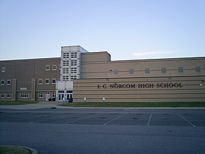
I. C. Norcom High School
Public high school in Portsmouth, Virginia
Distance: Approx. 785 meters
Latitude and longitude: 36.83608333,-76.31975
I. C. Norcom High School is a public high school in Portsmouth, Virginia. It is administered by Portsmouth City Public Schools. The school colors are maroon and grey, and the mascot is the Greyhounds.

Pythian Castle (Portsmouth, Virginia)
United States historic place
Distance: Approx. 1303 meters
Latitude and longitude: 36.83361111,-76.30138889
The Pythian Castle is a historic three-story brick-and-stone Knights of Pythias building located at 610-612 Court Street in Portsmouth, Virginia. Built between 1897 and 1898 for the Atlantic Lodge, Knights of Pythias, it was designed by architect Edward Overman in the Romanesque Revival style of architecture. Like many multistory urban fraternal buildings built in the late 19th and early 20th centuries, its street floor was rented out for retail and office spaces while the upper floors were reserved for lodge use.

St. Paul's Catholic Church (Portsmouth, Virginia)
Historic church in Virginia, United States
Distance: Approx. 1335 meters
Latitude and longitude: 36.8375,-76.30361111
St. Paul's Catholic Church is a historic Roman Catholic church located in Portsmouth, Virginia, United States. It is a compact Gothic Revival style, cruciform plan church.

Killing of Kirill Denyakin
2011 police shooting in Portsmouth, Virginia
Distance: Approx. 1078 meters
Latitude and longitude: 36.835857,-76.30566
Kirill Ivanovich Denyakin (Russian: Кирилл Иванович Денякин) was a 26-year-old Kazakhstani national, who was shot and killed by police officer Stephen Rankin in Portsmouth, Virginia on the evening of April 23, 2011. Unarmed at the time of the shooting, Denyakin was shot by Rankin, who was responding to a disturbance call at the home where Denyakin was staying. According to Portsmouth Police, Denyakin had ignored Rankin's verbal orders and lunged at him aggressively just prior to the shooting, forcing Rankin to defend himself.

Monumental Methodist Church
Historic church in Virginia, United States
Distance: Approx. 1291 meters
Latitude and longitude: 36.83583333,-76.30277778
Monumental United Methodist Church, formerly known as Dinwiddie Street Methodist Church, is a historic Methodist church located in Portsmouth, Virginia. It is a five-bay brick and stucco, Victorian Gothic style church. It is features a 182 feet tall, two part central tower.

Trinity Episcopal Church (Portsmouth, Virginia)
Historic church in Virginia, United States
Distance: Approx. 1346 meters
Latitude and longitude: 36.83472222,-76.30138889
Trinity Episcopal Church is a historic Episcopal church located in Portsmouth, Virginia. It was built between 1828 and 1830, and is a stuccoed brick building. It has an attached bell tower.

Portsmouth Courthouse
United States historic place
Distance: Approx. 1349 meters
Latitude and longitude: 36.83527778,-76.30166667
Portsmouth Courthouse, also known as Norfolk County Courthouse, is a historic courthouse building located at Portsmouth, Virginia, United States. It was built in 1846, and is a one-story with basement, Greek Revival style brick building. It measures 78 feet wide by 57 feet deep.

Commodore Theatre
Historic theatre in Portsmouth, Virginia, US
Distance: Approx. 1278 meters
Latitude and longitude: 36.83472222,-76.30222222
Commodore Theatre is an historic movie theater located at Portsmouth, Virginia. It was built in 1945 in the Streamline Art Deco style, and originally sat 1,000 people. The theater closed in 1975 and sat empty until a change in ownership and extensive renovation beginning in 1987.

Cedar Grove Cemetery (Portsmouth, Virginia)
Historic cemetery
Distance: Approx. 1195 meters
Latitude and longitude: 36.83888889,-76.30777778
Cedar Grove Cemetery is a historic public cemetery located at Portsmouth, Virginia. It was established by an act of the Virginia General Assembly in 1832. The cemetery contains more than 400 graves with monuments dating from the late 1700s to the present.

Downtown Portsmouth Historic District
Historic district in Virginia, United States
Distance: Approx. 1104 meters
Latitude and longitude: 36.83583333,-76.30527778
Downtown Portsmouth Historic District, also known as the High Street Corridor Historic District, is a national historic district located at Portsmouth, Virginia. It encompasses 229 contributing buildings, 1 contributing site, 4 contributing structures, and 1 contributing object in the central business district of Portsmouth. The district encompasses the original 1752 plan of the Town of Portsmouth and includes portions of expansions of the original boundaries dating to 1763 and 1909.

Portsmouth Community Library
United States historic place
Distance: Approx. 291 meters
Latitude and longitude: 36.83166667,-76.31277778
Portsmouth Community Library, also known as the Portsmouth Colored Community Library, is a historic library building located at Portsmouth, Virginia. It was built in 1945 at 804 South Street. It is a one-story, three-bay, brick building with a hipped roof.

East Radford Historic District
Historic district in Virginia, United States
Distance: Approx. 1381 meters
Latitude and longitude: 36.84194444,-76.31111111
East Radford Historic District is a national historic district located at Radford, Virginia. It encompasses 302 contributing buildings and 5 contributing structures in a mixed residential and commercial section of Radford, comprising most of the historic boundaries of the town of Central Depot. It was developed between 1866 and 1916, and includes notable examples of Queen Anne and Colonial Revival style architecture.
Weather in this IP's area
overcast clouds
4 Celsius
0 Celsius
3 Celsius
4 Celsius
1027 hPa
85 %
1027 hPa
1026 hPa
10000 meters
4.02 m/s
7.15 m/s
56 degree
100 %