198.252.232.94 - IP Lookup: Free IP Address Lookup, Postal Code Lookup, IP Location Lookup, IP ASN, Public IP
Country:
Region:
City:
Location:
Time Zone:
Postal Code:
ISP:
ASN:
language:
User-Agent:
Proxy IP:
Blacklist:
IP information under different IP Channel
ip-api
Country
Region
City
ASN
Time Zone
ISP
Blacklist
Proxy
Latitude
Longitude
Postal
Route
db-ip
Country
Region
City
ASN
Time Zone
ISP
Blacklist
Proxy
Latitude
Longitude
Postal
Route
IPinfo
Country
Region
City
ASN
Time Zone
ISP
Blacklist
Proxy
Latitude
Longitude
Postal
Route
IP2Location
198.252.232.94Country
Region
tennessee
City
la vergne
Time Zone
America/Chicago
ISP
Language
User-Agent
Latitude
Longitude
Postal
ipdata
Country
Region
City
ASN
Time Zone
ISP
Blacklist
Proxy
Latitude
Longitude
Postal
Route
Popular places and events near this IP address

La Vergne, Tennessee
City in Tennessee, United States
Distance: Approx. 1520 meters
Latitude and longitude: 36.01555556,-86.58194444
La Vergne ( lə-VURN) is a city in Rutherford County, Tennessee, United States. The population was 38,719 at the 2020 census. La Vergne lies within the Nashville Metropolitan Statistical Area.
Smyrna, Tennessee
Town in Tennessee, United States
Distance: Approx. 5371 meters
Latitude and longitude: 35.97944444,-86.52111111
Smyrna is a town in Rutherford County, Tennessee. Smyrna's population was 53,070 at the 2020 census, making it the largest town in Tennessee by population in that census. In 2007, U.S. News & World Report listed Smyrna as one of the best places in the United States to retire.

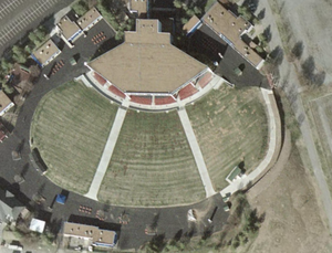
Starwood Amphitheatre
Distance: Approx. 4767 meters
Latitude and longitude: 36.03838889,-86.60691389
The Starwood Amphitheatre was the primary outdoor music venue in the Nashville, Tennessee area from 1986 to 2006. It was owned by Live Nation and had a capacity of 17,137. It had previously been owned by SFX Entertainment and Clear Channel Worldwide, both predecessors of Live Nation Entertainment.

Sewart Air Force Base
Former US Air Force base in Smyrna, Tennessee
Distance: Approx. 4142 meters
Latitude and longitude: 36.00888889,-86.52
Sewart Air Force Base (1941–1971) is a former United States Air Force base located in Smyrna, about 25 miles southeast of Nashville, Tennessee. During World War II, it was known as Smyrna Army Airfield.

Smyrna Airport (Tennessee)
Airport in Smyrna, TN, US
Distance: Approx. 4142 meters
Latitude and longitude: 36.00888889,-86.52
Smyrna Airport (IATA: MQY, ICAO: KMQY, FAA LID: MQY) is a public general aviation and military use airport located two nautical miles (4 km) north of the central business district of Smyrna, a town in Rutherford County, Tennessee, United States. It is owned by the Smyrna / Rutherford County Airport Authority. Smyrna Airport is the third largest airport in Tennessee and is the state's busiest general aviation airport.
La Vergne High School
Public high school in LaVergne, Tennessee, United States
Distance: Approx. 2533 meters
Latitude and longitude: 35.989,-86.5603
La Vergne High School is a public high school located in La Vergne, Tennessee, United States, with approximately 1,723 students. It was founded in 1988 and a part of the Rutherford County School System. As of 2020, the current principal of the school is Dr.
Antioch High School (Tennessee)
Public high school in Nashville, Davidson County, Tennessee, United States
Distance: Approx. 4956 meters
Latitude and longitude: 36.04694444,-86.59888889
Antioch High School (AHS) is a public high school located in Antioch, Tennessee, USA. It is located at 1900 Hobson Pike. It is a comprehensive high school for grades 9–12 and one of 19 high schools administered by Metropolitan Nashville Public Schools.

Cane Ridge Cumberland Presbyterian Church
Historic church in Tennessee, United States
Distance: Approx. 6216 meters
Latitude and longitude: 36.00166667,-86.63388889
Cane Ridge Cumberland Presbyterian Church is a historic church in Antioch, Tennessee. It was built in 1859 and added to the National Register in 1976.
Benajah Gray Log House
Historic house in Tennessee, United States
Distance: Approx. 5709 meters
Latitude and longitude: 35.99333333,-86.62527778
The Benajah Gray Log House is a historic loghouse in Antioch, Tennessee, United States.
Burnette Chapel shooting
Mass shooting in Nashville, Tennessee
Distance: Approx. 4241 meters
Latitude and longitude: 36.0468,-86.583
A mass shooting occurred on September 24, 2017, when a gunman opened fire at the Burnette Chapel Church of Christ in Antioch, Tennessee, part of the Greater Nashville area, killing one person and injuring six others. The perpetrator was identified as Emanuel Kidega Samson, a 25-year-old native of Sudan. Samson was arrested after getting into an altercation with a bystander, and charged with first-degree murder and 43 other charges.
Idler's Retreat
Historic house in Tennessee, United States
Distance: Approx. 5273 meters
Latitude and longitude: 35.9875,-86.51527778
Idler's Retreat, also known as the Dillon-Tucker-Cheney House, is a historic house in Smyrna, Tennessee, U.S.. It was built circa 1865 by J. D. Dillon. In 1882, it was purchased by John F. Tucker, and renamed Tucker Place.
Nashville Waffle House shooting
Mass shooting in Nashville, Tennessee
Distance: Approx. 6251 meters
Latitude and longitude: 36.05055556,-86.61555556
On April 22, 2018, a mass shooting occurred at a Waffle House restaurant in the Antioch neighborhood of Nashville, Tennessee, United States, when 29-year-old Travis Jeffrey Reinking fatally shot four people and injured two others with an AR-15 style rifle. Another two people were injured by broken glass. Reinking was rushed by an unarmed customer, James Shaw Jr., who wrestled the rifle away and stopped the shooting spree.
Weather in this IP's area
overcast clouds
2 Celsius
-1 Celsius
0 Celsius
4 Celsius
1029 hPa
56 %
1029 hPa
1006 hPa
10000 meters
2.57 m/s
190 degree
100 %


