Country:
 USA
USARegion:
City:
Latitude and Longitude:
Time Zone:
Postal Code:
IP information under different IP Channel
ip-api
Country
Region
City
ASN
Time Zone
ISP
Blacklist
Proxy
Latitude
Longitude
Postal
Route
IPinfo
Country
Region
City
ASN
Time Zone
ISP
Blacklist
Proxy
Latitude
Longitude
Postal
Route
MaxMind
Country
Region
City
ASN
Time Zone
ISP
Blacklist
Proxy
Latitude
Longitude
Postal
Route
Luminati
Country
USASN
Time Zone
America/Chicago
ISP
WINTEK-CORP
Latitude
Longitude
Postal
db-ip
Country
Region
City
ASN
Time Zone
ISP
Blacklist
Proxy
Latitude
Longitude
Postal
Route
ipdata
Country
Region
City
ASN
Time Zone
ISP
Blacklist
Proxy
Latitude
Longitude
Postal
Route
Popular places and events near this IP address

Roman Catholic Diocese of Lafayette in Indiana
Latin Catholic ecclesiastical jurisdiction in Indiana, USA
Distance: Approx. 1974 meters
Latitude and longitude: 40.41722222,-86.87861111
The Diocese of Lafayette in Indiana (Latin: Dioecesis Lafayettensis in Indiana) is a Latin Church ecclesiastical territory, or diocese, of the Catholic Church in central Indiana in the United States. The current bishop is Timothy L. Doherty. The Diocese of Lafayette in Indiana is a suffragan diocese in the ecclesiastical province of the metropolitan Archdiocese of Indianapolis.
Franciscan Health Lafayette Central
Distance: Approx. 1199 meters
Latitude and longitude: 40.427472,-86.879449
Franciscan Health Lafayette Central is no longer a hospital, but houses Franciscan Health Community Education, various medical offices and the St. Elizabeth School of Nursing (the only hospital-based nursing school in the state of Indiana). Franciscan Health Lafayette Central, previously known as St.
Lafayette Home Hospital
Distance: Approx. 1595 meters
Latitude and longitude: 40.41833333,-86.86877778
Lafayette Home Hospital was a 270-bed medical center in Lafayette, Indiana, United States, owned by the not-for-profit Franciscan Health, a division of Sisters of St. Francis Health Services, Inc. The facility ceased all medical services on February 25, 2010.
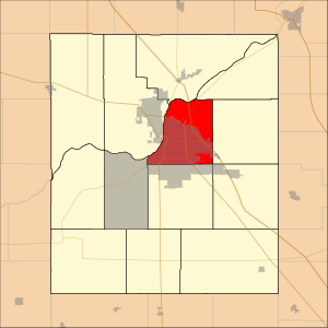
Fairfield Township, Tippecanoe County, Indiana
Township in Indiana, United States
Distance: Approx. 1213 meters
Latitude and longitude: 40.42666667,-86.855
Fairfield Township is one of thirteen townships in Tippecanoe County, Indiana. As of the 2010 census, its population was 51,113 and it contained 24,527 housing units.
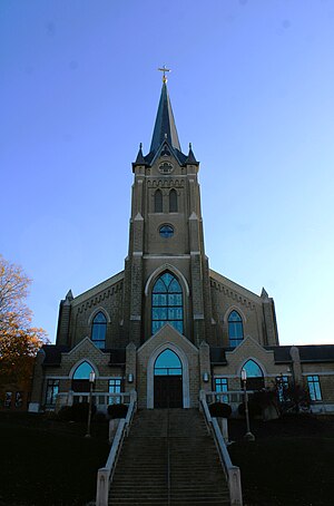
Saint James Lutheran Church and School (Lafayette, Indiana)
Historic church in Indiana, United States
Distance: Approx. 2061 meters
Latitude and longitude: 40.423,-86.8878
Saint James Lutheran Church and School located in Lafayette, Indiana was founded in 1850 by German immigrants, is a member of the Lutheran Church–Missouri Synod and is a Confessional Lutheran congregation with approximately 800 active members. Average weekly worship attendance is approximately 550 at four services. The school associated with the church was also founded in 1850, and is the oldest school in Tippecanoe County.
Columbian Park Zoo
Zoo in Indiana, United States
Distance: Approx. 2082 meters
Latitude and longitude: 40.4141335,-86.8709012
The Columbian Park Zoo is a seasonal zoo located in Lafayette, Indiana, at Columbian Park. The zoo is home to more than 190 animals from over 90 species. The zoo is in Columbian Park, which also includes playgrounds, picnic areas, a walking trail, and a baseball stadium.
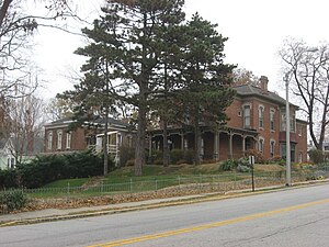
St. Mary Historic District (Lafayette, Indiana)
Historic district in Indiana, United States
Distance: Approx. 2100 meters
Latitude and longitude: 40.41694444,-86.88083333
St. Mary Historic District is a national historic district located at Lafayette, Tippecanoe County, Indiana. In 1864, St.
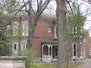
Waldron–Beck House and Carriage House
Historic house in Indiana, United States
Distance: Approx. 886 meters
Latitude and longitude: 40.42583333,-86.8725
Waldron–Beck House and Carriage House is a historic home and carriage house located at Lafayette, Tippecanoe County, Indiana. The house was built in 1877, and is a two-story, irregularly shaped Italianate style brick dwelling, with a rear service wing. It sits on a stone foundation and has a multi-hipped roof with bracketed cornice.

Scott Street Pavilion
United States historic place
Distance: Approx. 1999 meters
Latitude and longitude: 40.415,-86.87166667
Scott Street Pavilion is a historic park pavilion located in Columbian Park at Lafayette, Tippecanoe County, Indiana. It was built in 1899, and is a 1+1⁄2-story, rectangular, wood-frame building. It is sheathed in clapboard siding and has a hipped roof that extends to form a verandah on all sides.: 2–3 It was listed on the National Register of Historic Places in 1984.

Jefferson Historic District (Lafayette, Indiana)
Historic district in Indiana, United States
Distance: Approx. 1895 meters
Latitude and longitude: 40.42194444,-86.88444444
Jefferson Historic District is a national historic district located at Lafayette, Tippecanoe County, Indiana. The district encompasses 161 contributing buildings, 2 contributing sites, and 22 contributing structures in a predominantly residential section of Lafayette. It developed between about 1853 and 1951 and includes representative examples of Italianate, Greek Revival, and Bungalow / American Craftsman style architecture.

Park Mary Historic District
Historic district in Indiana, United States
Distance: Approx. 1596 meters
Latitude and longitude: 40.42583333,-86.88361111
Park Mary Historic District is a national historic district located at Lafayette, Tippecanoe County, Indiana. The district encompasses 106 contributing buildings and 1 contributing structure in a predominantly residential section of Lafayette. It developed between about 1853 and 1950 and includes representative examples of Italianate, Queen Anne, and Bungalow / American Craftsman style architecture.
Perrin Historic District
Historic district in Indiana, United States
Distance: Approx. 1720 meters
Latitude and longitude: 40.42055556,-86.87972222
Perrin Historic District is a national historic district located at Lafayette, Tippecanoe County, Indiana. The district encompasses 173 contributing buildings and 2 contributing structures in a predominantly residential section of Lafayette. It developed between about 1869 and 1923 and includes representative examples of Italianate, Queen Anne, Colonial Revival, Stick Style / Eastlake movement, and Bungalow / American Craftsman style architecture.
Weather in this IP's area
clear sky
31 Celsius
29 Celsius
30 Celsius
31 Celsius
1017 hPa
23 %
1017 hPa
996 hPa
10000 meters
4.12 m/s
50 degree
07:29:44
19:54:44