Country:
 USA
USARegion:
City:
Latitude and Longitude:
Time Zone:
Postal Code:
IP information under different IP Channel
ip-api
Country
Region
City
ASN
Time Zone
ISP
Blacklist
Proxy
Latitude
Longitude
Postal
Route
IPinfo
Country
Region
City
ASN
Time Zone
ISP
Blacklist
Proxy
Latitude
Longitude
Postal
Route
MaxMind
Country
Region
City
ASN
Time Zone
ISP
Blacklist
Proxy
Latitude
Longitude
Postal
Route
Luminati
Country
USASN
Time Zone
America/Chicago
ISP
IMONC
Latitude
Longitude
Postal
db-ip
Country
Region
City
ASN
Time Zone
ISP
Blacklist
Proxy
Latitude
Longitude
Postal
Route
ipdata
Country
Region
City
ASN
Time Zone
ISP
Blacklist
Proxy
Latitude
Longitude
Postal
Route
Popular places and events near this IP address

Paramount Theatre (Cedar Rapids, Iowa)
United States historic place
Distance: Approx. 229 meters
Latitude and longitude: 41.97655556,-91.66708333
The Paramount Theatre is a 1,693-seat theater in Cedar Rapids, Iowa. It was individually listed on the National Register of Historic Places in 1976. In 2015 it was included as a contributing property in the Cedar Rapids Central Business District Commercial Historic District.

Mays Island
United States historic place
Distance: Approx. 183 meters
Latitude and longitude: 41.97583333,-91.67027778
May's Island (or Mays Island) is a small island on the Cedar River, in Cedar Rapids, Iowa. Functioning as a civic center much like the Île de la Cité, it is the site of the Memorial Building (the city hall), the Linn County Courthouse, and the county jail. The island plus an adjacent block was listed as a historic district on the National Register of Historic Places in 1978.

Linn County Courthouse (Iowa)
United States historic place
Distance: Approx. 264 meters
Latitude and longitude: 41.97502778,-91.66963889
The Linn County Courthouse is located on May's Island in the middle of the Cedar River in Cedar Rapids, Iowa, United States. It, along with the Veterans Memorial Building and two other buildings, is a contributing property to the May's Island Historic District that was listed on the National Register of Historic Places in 1978. The courthouse is the third building the county has used for court functions and county administration.

Hotel Roosevelt (Cedar Rapids, Iowa)
United States historic place
Distance: Approx. 223 meters
Latitude and longitude: 41.97916667,-91.66833333
The Hotel Roosevelt is a historic structure located in downtown Cedar Rapids, Iowa, United States. It was individually listed on the National Register of Historic Places in 1991. In 2015 it was included as a contributing property in the Cedar Rapids Central Business District Commercial Historic District.

Security Building (Cedar Rapids, Iowa)
United States historic place
Distance: Approx. 179 meters
Latitude and longitude: 41.97777778,-91.6675
The Security Building is a historic structure located in downtown Cedar Rapids, Iowa, United States. The building is eight stories tall and rises 117 feet (36 m) above the ground. It was designed by the Cedar Rapids architectural firm of Josselyn & Taylor, and it was completed in 1908.

First Avenue Bridge
United States historic place
Distance: Approx. 162 meters
Latitude and longitude: 41.97727778,-91.67155556
The First Avenue Bridge is a historic structure located in downtown Cedar Rapids, Iowa, United States. It carries U.S. Route 151 for 697 feet (212 m) over the Cedar River. The original six-span concrete arch structure was completed in 1920 for $420,000.

Cedar Rapids Post Office and Public Building
United States historic place
Distance: Approx. 307 meters
Latitude and longitude: 41.97833333,-91.66611111
The Cedar Rapids Post Office and Public Building, also known as the Witwer Building, is a historic building located in downtown Cedar Rapids, Iowa, United States. It was individually listed on the National Register of Historic Places in 1982. In 2015 it was included as a contributing property in the Cedar Rapids Central Business District Commercial Historic District.
Highwater Rock
United States historic place
Distance: Approx. 236 meters
Latitude and longitude: 41.97861111,-91.67194444
The Highwater Rock is located in the Cedar River near downtown Cedar Rapids, Iowa, United States. It is a large granite boulder in the rapids in the eastern half of the river. Its height depends on the river level.

Hamilton Brothers Building
United States historic place
Distance: Approx. 320 meters
Latitude and longitude: 41.97508333,-91.66730556
The Hamilton Brothers Building, also known as Warfield-Pratt & Howell Co. Wholesale Grocers, and the Hach Brothers Company, is a historic building located in Cedar Rapids, Iowa, United States. This is the only extant building associated with local businessman and politician John Taylor Hamilton.
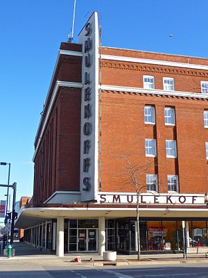
Smulekoffs Furniture Store
United States historic place
Distance: Approx. 232 meters
Latitude and longitude: 41.97572222,-91.66794444
Smulekoffs Furniture Store, also known as the Sinclair Building, New Sinclair Building, Warfield–Pratt–Howell Co. building and the Churchill Drug Co. building, is a historic building located in Cedar Rapids, Iowa, United States.

Cedar Rapids Central Business District Commercial Historic District
Historic district in Iowa, United States
Distance: Approx. 335 meters
Latitude and longitude: 41.9775,-91.66555556
The Cedar Rapids Central Business District Commercial Historic District is a nationally recognized historic district located in Cedar Rapids, Iowa, United States. It was listed on the National Register of Historic Places in 2015. At the time of its nomination it consisted of 60 resources, which included 46 contributing buildings, one contributing structure, 12 non-contributing buildings, and one non-contributing structure.
KOJC
Radio station in Cedar Rapids, Iowa (1978–1993)
Distance: Approx. 185 meters
Latitude and longitude: 41.97888889,-91.66861111
KOJC was a radio station in Cedar Rapids, Iowa, owned by the Oakhill-Jackson Economic Development Corporation. The station operated from June 1978 to 1993 and provided programming by and for the African American community in Cedar Rapids.
Weather in this IP's area
scattered clouds
31 Celsius
34 Celsius
30 Celsius
32 Celsius
1009 hPa
54 %
1009 hPa
985 hPa
10000 meters
5.66 m/s
10.29 m/s
170 degree
40 %
06:51:29
19:09:11