Country:
Region:
City:
Latitude and Longitude:
Time Zone:
Postal Code:
IP information under different IP Channel
ip-api
Country
Region
City
ASN
Time Zone
ISP
Blacklist
Proxy
Latitude
Longitude
Postal
Route
Luminati
Country
ASN
Time Zone
America/Chicago
ISP
TELX-LEGACY
Latitude
Longitude
Postal
IPinfo
Country
Region
City
ASN
Time Zone
ISP
Blacklist
Proxy
Latitude
Longitude
Postal
Route
db-ip
Country
Region
City
ASN
Time Zone
ISP
Blacklist
Proxy
Latitude
Longitude
Postal
Route
ipdata
Country
Region
City
ASN
Time Zone
ISP
Blacklist
Proxy
Latitude
Longitude
Postal
Route
Popular places and events near this IP address

South Ferry station (IRT elevated)
Former Manhattan Railway elevated station (closed 1950)
Distance: Approx. 130 meters
Latitude and longitude: 40.70155556,-74.01361111
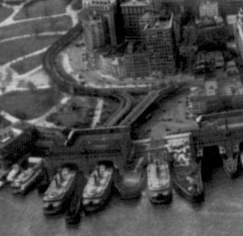
The South Ferry station was an elevated station at the southern terminal of the IRT Second, Third, Sixth and Ninth Avenue Lines. It was located next to Battery Park at the lower tip of Manhattan, New York City. Two tracks came from the combined Second and Third Avenue Lines, and two from the Sixth and Ninth Avenue Lines, making four tracks at the terminal, with platforms on the outside and between each pair of tracks (no platform in the center).

Whitehall Street
Street in Manhattan, New York
Distance: Approx. 27 meters
Latitude and longitude: 40.70283333,-74.01302778
Whitehall Street is a street in the South Ferry/Financial District neighborhood of Lower Manhattan in New York City, near the southern tip of Manhattan Island. The street begins at Bowling Green to the north, where it is a continuation of the southern end of Broadway. Whitehall Street stretches four blocks to the southern end of FDR Drive, adjacent to the Staten Island Ferry's Whitehall Terminal, on landfill beyond the site of Peter Stuyvesant's 17th-century house.

Great Fire of New York (1776)
Major fire in New York
Distance: Approx. 45 meters
Latitude and longitude: 40.70305556,-74.01305556
The Great Fire of New York was a devastating fire that burned through the night of September 20, 1776, and into the morning of September 21, on the West Side of what then constituted New York City at the southern end of the island of Manhattan. It broke out in the early days of the military occupation of the city by British forces during the American Revolutionary War. The fire destroyed from 10 to 25 percent of the buildings in the city, while some unaffected parts of the city were plundered.

17 State Street
Office skyscraper in Manhattan, New York
Distance: Approx. 50 meters
Latitude and longitude: 40.70277778,-74.01388889
17 State Street is a 42-story office building along State Street and Battery Park in the Financial District of Lower Manhattan in New York City. Completed in 1988, it was designed by Roy Gee for Emery Roth and Sons for developers William Kaufman Organization and JMB Realty. The building is shaped like a quarter round, with a curved glass facade facing New York Harbor.

South Ferry/Whitehall Street station
New York City Subway station in Manhattan
Distance: Approx. 48 meters
Latitude and longitude: 40.7025,-74.0128
The South Ferry/Whitehall Street station is a New York City Subway station complex in the Financial District neighborhood of Manhattan, under Battery Park. The complex is shared by the IRT Broadway–Seventh Avenue Line and the BMT Broadway Line. It is served by the 1 and R trains at all times, the W train only on weekdays during the day, and the N train at night.
Bridge Street (Manhattan)
Street in Manhattan, New York
Distance: Approx. 99 meters
Latitude and longitude: 40.70355278,-74.01295556
Bridge Street is a street in the Financial District of Lower Manhattan in New York City, running two blocks from State Street in the west to Broad Street in the east. It intersects Whitehall Street.

James Watson House
Historic house in Manhattan, New York
Distance: Approx. 71 meters
Latitude and longitude: 40.70251111,-74.01410278
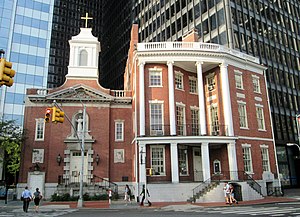
The James Watson House, at 7 State Street between Pearl and Water Streets in the Financial District of Manhattan, New York City, was built in 1793 and extended in 1806, and is now the rectory of the Shrine of St. Elizabeth Ann Bayley Seton. It is located near the southern tip of Manhattan Island, across from Battery Park.

Kemble Building
Distance: Approx. 125 meters
Latitude and longitude: 40.7038,-74.013
The Kemble Building was an eight-story edifice located at 15–25 Whitehall Street between Bridge Street and Stone Street. It stood opposite the Custom House in the Financial District of Lower Manhattan, New York City. Owned by the Ogden Goelet Estate, the structure adjoined the seven-story New York Produce Exchange Building.

Shrine of St. Elizabeth Ann Bayley Seton
Distance: Approx. 48 meters
Latitude and longitude: 40.70253333,-74.01383056
The Shrine of St. Elizabeth Ann Bayley Seton is located in the Church of Our Lady of the Holy Rosary, a Roman Catholic parish church of the Roman Catholic Archdiocese of New York at 7 State Street, between Pearl and Water Streets in the Financial District of Manhattan, New York City.

Peter Minuit Plaza
Plaza in Manhattan, New York
Distance: Approx. 68 meters
Latitude and longitude: 40.70209,-74.01325
Peter Minuit Plaza is an urban square serving the intermodal transportation hub at South Ferry, and lies at the intersection of State Street and Whitehall Street in the Financial District of Lower Manhattan. The plaza is a heavy pedestrian traffic area just north of the Staten Island Ferry Whitehall Terminal and includes two exits for the New York City Subway's South Ferry/Whitehall Street station as well as the M15 SBS South Ferry Bus Loop at Peter Minuit Place, making this a busy intersection that is used by approximately 70,000 residents and visitors daily. The space was dedicated in 1953 (marking the 300th anniversary of the charter of New Amsterdam) as a smaller triangular plaza at the Kapsee, a historic point at the original southern tip of Manhattan, as part of the Battery's re-landscaping, with the Jewish Tercentenary Monument added in 1955.

2 New York Plaza
Office skyscraper in Manhattan, New York
Distance: Approx. 60 meters
Latitude and longitude: 40.70258,-74.01261
125 Broad Street (formerly known as 2 New York Plaza) is an office building in the Financial District of Manhattan in New York City, at the intersection of Broad Street and South Street near South Ferry. The building, standing 504 feet (154 m) tall with 40 floors, is one of the southernmost skyscrapers in Lower Manhattan. The building was designed by the Kahn & Jacobs architecture firm, and developed by Sol Atlas and John P. McGrath.

Amelia (company)
American technology company
Distance: Approx. 50 meters
Latitude and longitude: 40.70277778,-74.01388889
Amelia, formerly known as IPsoft, is an American technology company. It primarily focuses on artificial intelligence and cognitive and autonomic products for business. Its main products are Amelia, a Conversational AI platform, and Amelia AIOps, an IT operations management platform.
Weather in this IP's area
clear sky
8 Celsius
5 Celsius
7 Celsius
10 Celsius
1013 hPa
36 %
1013 hPa
1013 hPa
10000 meters
5.14 m/s
340 degree
06:43:32
16:38:12