Country:
Region:
City:
Latitude and Longitude:
Time Zone:
Postal Code:
IP information under different IP Channel
ip-api
Country
Region
City
ASN
Time Zone
ISP
Blacklist
Proxy
Latitude
Longitude
Postal
Route
Luminati
Country
Region
id
City
hayden
ASN
Time Zone
America/Los_Angeles
ISP
CEC
Latitude
Longitude
Postal
IPinfo
Country
Region
City
ASN
Time Zone
ISP
Blacklist
Proxy
Latitude
Longitude
Postal
Route
db-ip
Country
Region
City
ASN
Time Zone
ISP
Blacklist
Proxy
Latitude
Longitude
Postal
Route
ipdata
Country
Region
City
ASN
Time Zone
ISP
Blacklist
Proxy
Latitude
Longitude
Postal
Route
Popular places and events near this IP address

Dalton Gardens, Idaho
City in Kootenai County, Idaho, United States
Distance: Approx. 7728 meters
Latitude and longitude: 47.73333333,-116.77194444
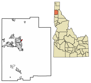
Dalton Gardens is a city in Kootenai County, Idaho, United States. It is considered a suburb of Coeur d'Alene and borders the city to the north and east. The city of Dalton Gardens is also part of the larger Spokane-Coeur d'Alene Combined Metropolitan Statistical Area which encompasses Kootenai County, Idaho.

Hayden, Idaho
City in Idaho, United States
Distance: Approx. 5966 meters
Latitude and longitude: 47.75722222,-116.78888889
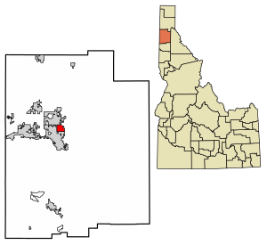
Hayden is a city in Kootenai County, Idaho, United States. Located in the northern portion of the state, it is a suburb of nearby Coeur d'Alene and its population was 15,570 at the 2020 census.

Hayden Lake, Idaho
City in Idaho, United States
Distance: Approx. 4032 meters
Latitude and longitude: 47.76472222,-116.75583333
Hayden Lake is a city in Kootenai County, Idaho, United States. Located in the northern portion of the state, it is considered a suburb of the city of Coeur d'Alene. Its population was 574 at the 2010 census.

Lake Hayden
Lake in northern Idaho
Distance: Approx. 4355 meters
Latitude and longitude: 47.762476,-116.71924
Lake Hayden, also known as Hayden Lake, is located Kootenai County, Idaho, United States. It is one of several natural lakes in the northern Idaho region. The lake is part of the Spokane Valley–Rathdrum Prairie Aquifer.
Garwood, Idaho
Unincorporated community in the state of Idaho, United States
Distance: Approx. 4630 meters
Latitude and longitude: 47.83194444,-116.7775
Garwood is an unincorporated community in northern Kootenai County, Idaho, United States.

Coeur d'Alene Airport
Airport in Kootenai County, Idaho
Distance: Approx. 6597 meters
Latitude and longitude: 47.77444444,-116.81944444
Coeur d'Alene Airport / Pappy Boyington Field (IATA: COE, ICAO: KCOE, FAA LID: COE) is a county-owned public-use airport, located in Kootenai County, Idaho, United States. It is located nine miles (14 km) northwest of the central business district of Coeur d'Alene and is surrounded by the city of Hayden on three sides. The airport was known as Coeur d'Alene Air Terminal until September 2007, when it was renamed Coeur d'Alene Airport / Pappy Boyington Field to honor World War II multiple ace Col.
Sunshine Minting
American metal processing company
Distance: Approx. 8571 meters
Latitude and longitude: 47.733266,-116.798455
Sunshine Minting, Inc., is a privately held company based in Coeur d'Alene, Idaho, that processes silver, gold and other precious metals. It is known as a supplier of silver planchets to the United States Mint and as the manufacturer of the private Liberty Dollar coins. Sunshine Minting provides custom minting services and has an on-site storage vault program for customers who own at least 10 ounces of gold or 500 ounces of silver.
Clarksville, Idaho
Unincorporated community in the state of Idaho, United States
Distance: Approx. 5066 meters
Latitude and longitude: 47.75388889,-116.73305556
Clarksville is an unincorporated community in Kootenai County, Idaho, United States. Clarksville is located on the south shore of Lake Hayden, 6 miles (9.7 km) north-northeast of Coeur d'Alene.
Silver Lake Mall
Shopping mall in Idaho, United States
Distance: Approx. 8410 meters
Latitude and longitude: 47.73167,-116.7897
Silver Lake Mall is a shopping mall located in Coeur d'Alene, Idaho. It is the largest indoor shopping center in North Idaho. Its anchor stores are Black Sheep Sporting Goods, Inspiro, Jo-Ann Fabrics, Macy's, and Planet Fitness.

Clark House (Clarksville, Idaho)
United States historic place
Distance: Approx. 4910 meters
Latitude and longitude: 47.75611111,-116.72527778
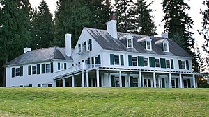
The Clark House is a historic house in Clarksville, Idaho. It was built in 1910 as a summer residence for F. Lewis Clark, a mining millionaire who disappeared in Santa Barbara in 1914 and was believed to have committed suicide. Clark's servants lived in the wings.
Jacob and Cristina Thunborg House
United States historic place
Distance: Approx. 4677 meters
Latitude and longitude: 47.78083333,-116.68305556
The Jacob and Cristina Thunborg House is a historic log cabin located at Chicken Point in Hayden Lake, Idaho. It was built in 1893-1902 by Jacob Thunborg and his wife Cristina, two Swedish immigrants who became homesteaders in Idaho. The Thunborgs lived here with their son, Frank, and their daughter, Lena.

John A. Finch Caretaker's House
United States historic place
Distance: Approx. 4725 meters
Latitude and longitude: 47.75833333,-116.75638889
The John A. Finch Caretaker's House is a historic house in Hayden Lake, Idaho. It was built in 1903 for John A. Finch, a significant investor in Coeur d'Alene's mines. It was designed in the Swiss Chalet style by architect Kirtland Cutter.
Weather in this IP's area
clear sky
1 Celsius
-1 Celsius
-0 Celsius
3 Celsius
1017 hPa
86 %
1017 hPa
925 hPa
10000 meters
2.57 m/s
250 degree
06:38:26
16:22:42