Country:
 USA
USARegion:
City:
Latitude and Longitude:
Time Zone:
Postal Code:
IP information under different IP Channel
ip-api
Country
Region
City
ASN
Time Zone
ISP
Blacklist
Proxy
Latitude
Longitude
Postal
Route
IPinfo
Country
Region
City
ASN
Time Zone
ISP
Blacklist
Proxy
Latitude
Longitude
Postal
Route
MaxMind
Country
Region
City
ASN
Time Zone
ISP
Blacklist
Proxy
Latitude
Longitude
Postal
Route
Luminati
Country
USRegion
ca
City
sandiego
ASN
Time Zone
America/Los_Angeles
ISP
SDSC-AS
Latitude
Longitude
Postal
db-ip
Country
Region
City
ASN
Time Zone
ISP
Blacklist
Proxy
Latitude
Longitude
Postal
Route
ipdata
Country
Region
City
ASN
Time Zone
ISP
Blacklist
Proxy
Latitude
Longitude
Postal
Route
Popular places and events near this IP address

Balboa Stadium
American multi-sport stadium in San Diego, California
Distance: Approx. 439 meters
Latitude and longitude: 32.72083333,-117.15055556
Balboa Stadium is an outdoor stadium in San Diego, California, located adjacent to San Diego High School. The stadium primarily hosts local football and soccer games. Owned by the City of San Diego, it is leased to the San Diego Unified School District.
San Diego City College
Public community college in San Diego, California
Distance: Approx. 403 meters
Latitude and longitude: 32.71745,-117.15255
San Diego City College (City College or City) is a public community college in San Diego, California. It is part of the San Diego Community College District and the California Community Colleges system. The college is accredited by the Accrediting Commission for Community and Junior Colleges (ACCJC).
San Diego High School
Comprehensive public high school in San Diego, California, United States
Distance: Approx. 254 meters
Latitude and longitude: 32.72055556,-117.1525
San Diego High School (SDHS) is an urban public high school located on the southern edge of Balboa Park in San Diego, California, United States. It is the oldest high school in the San Diego Unified School District, one of the oldest public schools in all of California, and the oldest still on its original site.

Jacobs Music Center
Symphony hall in San Diego, California, US
Distance: Approx. 290 meters
Latitude and longitude: 32.719024,-117.157903
Jacobs Music Center is a performing arts theater in San Diego, California. It opened in 1929 as the Fox Theatre, a Gothic-revival luxury theater. It was conferred to the San Diego Symphony in 1984.
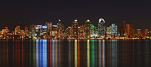
Downtown San Diego
City center of San Diego, California, United States
Distance: Approx. 76 meters
Latitude and longitude: 32.72055556,-117.15444444
Downtown San Diego is the central business district of San Diego, California, the eighth largest city in the United States. It houses the major local headquarters of the city, county, state, and federal governments. The area comprises seven districts: Gaslamp Quarter, East Village, Columbia, Marina, Cortez Hill, Little Italy, and Core.

Core, San Diego
Neighborhood of San Diego, California, US
Distance: Approx. 400 meters
Latitude and longitude: 32.71815,-117.15861944
Core is a neighborhood in downtown San Diego, California. It is the central business district of downtown San Diego.
1961 American Football League Championship Game
Distance: Approx. 441 meters
Latitude and longitude: 32.7205,-117.1505
The 1961 AFL Championship Game was a rematch of the first American Football League title game, between the Houston Oilers and the San Diego Chargers. It was played on December 24 at Balboa Stadium in San Diego, California, and the Oilers were three-point favorites.

Symphony Towers
Commercial offices, hotel in San Diego, California
Distance: Approx. 333 meters
Latitude and longitude: 32.718307,-117.157855
Symphony Towers is a 1.2-million-square-foot late modernist two-tower hotel and office complex located in the historic Financial District in downtown San Diego, California, on B Street. The mixed-use, high-rise building includes a 34-story office building with 530,000 square feet of rentable space, the 264-room Marriott Vacation Club Pulse San Diego, a five-level parking structure and the 2,255-seat Jacobs Music Center. In addition, the penthouse floor houses the exclusive University Club, and the tower has a helipad on the roof.
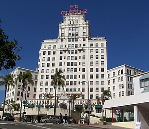
El Cortez (San Diego)
United States historic place
Distance: Approx. 267 meters
Latitude and longitude: 32.72027778,-117.15805556
El Cortez is a condominium building in San Diego, California. Built from 1926 to 1927, the El Cortez was the tallest building in San Diego when it opened. It sits atop a hill at the north end of downtown San Diego, where it dominated the city skyline for many years and became a landmark hotel.

Vantage Pointe Condominium
Residential in San Diego, California
Distance: Approx. 243 meters
Latitude and longitude: 32.718225,-117.156
Vantage Pointe Condominium is a high-rise 40 story building in San Diego, California. Construction began in 2006 and ended in 2008. It is one of downtown San Diego's largest apartment buildings, surpassed only by the Pinnacle West Tower by about 60 feet.

Imperial Bank Tower
Office in San Diego, California
Distance: Approx. 394 meters
Latitude and longitude: 32.7175,-117.15777778
Imperial Bank Tower, also known as 701B, is the 25th tallest building in San Diego, California, and is a prominent fixture in San Diego's skyline. The 24-story skyscraper has a height of 355 ft (108 m) and is located in the Core district of downtown San Diego. It was constructed in 1982.
East Village High School
Public school in the United States
Distance: Approx. 332 meters
Latitude and longitude: 32.7192,-117.1519
East Village High School (EVHS) is a public high school in downtown San Diego, California. It is located on the campus of San Diego City College. The school is part of the San Diego Unified School District.
Weather in this IP's area
scattered clouds
23 Celsius
23 Celsius
21 Celsius
25 Celsius
1011 hPa
60 %
1011 hPa
1006 hPa
10000 meters
6.17 m/s
270 degree
40 %
06:35:15
18:49:15