198.2.58.130 - IP Lookup: Free IP Address Lookup, Postal Code Lookup, IP Location Lookup, IP ASN, Public IP
Country:
 USA
USARegion:
City:
Location:
Time Zone:
Postal Code:
ISP:
ASN:
language:
User-Agent:
Proxy IP:
Blacklist:
IP information under different IP Channel
ip-api
Country
Region
City
ASN
Time Zone
ISP
Blacklist
Proxy
Latitude
Longitude
Postal
Route
db-ip
Country
Region
City
ASN
Time Zone
ISP
Blacklist
Proxy
Latitude
Longitude
Postal
Route
IPinfo
Country
Region
City
ASN
Time Zone
ISP
Blacklist
Proxy
Latitude
Longitude
Postal
Route
IP2Location
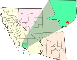
198.2.58.130Country
usRegion
california
City
santa fe springs
Time Zone
America/Los_Angeles
ISP
Language
User-Agent
Latitude
Longitude
Postal
ipdata
Country
Region
City
ASN
Time Zone
ISP
Blacklist
Proxy
Latitude
Longitude
Postal
Route
Popular places and events near this IP address

Santa Fe Springs, California
City in California, United States
Distance: Approx. 240 meters
Latitude and longitude: 33.9375,-118.06722222
Santa Fe Springs (Santa Fe, Spanish for "Holy Faith") is a city in Los Angeles County, California, United States. It is one of the Gateway Cities of southeast Los Angeles County. The population was 16,223 at the 2010 census, down from 17,438 in the 2000 census.

Metropolitan State Hospital (California)
Hospital in California, United States
Distance: Approx. 955 meters
Latitude and longitude: 33.9277,-118.0725
Metropolitan State Hospital is an American public hospital specializing in psychiatric care for those with mental health concerns, located at 11400 Norwalk Blvd in the city of Norwalk in Los Angeles County, California. As of August 2016 it had 780 patients.

California's 38th congressional district
U.S. House district for California
Distance: Approx. 771 meters
Latitude and longitude: 33.94055556,-118.0625
California's 38th congressional district is a congressional district in the U.S. state of California based in suburban eastern Los Angeles County and Orange County, California. The district is currently represented by Democrat Linda Sánchez. The district covers several cities in the San Gabriel Valley and the Gateway Cities region of Los Angeles including the cities of: Diamond Bar, Industry, La Habra Heights, La Mirada, Montebello, Norwalk, Pico Rivera, Santa Fe Springs, Walnut, and Whittier.

Santa Fe High School (California)
Public high school in Santa Fe Springs, California, United States
Distance: Approx. 2075 meters
Latitude and longitude: 33.94,-118.09
Santa Fe High School is a public high school located in Santa Fe Springs, California. The school has an enrollment of approximately 3,000 students and was founded in 1954 as a part of the Whittier Union High School District. It serves students in grades 9–12 in the cities of Santa Fe Springs, Norwalk, Downey, and Whittier.

St. Paul High School (Santa Fe Springs, California)
Private, college-prep school in Santa Fe Springs, California, United States
Distance: Approx. 2287 meters
Latitude and longitude: 33.95138889,-118.0525
St. Paul High School is a private, Catholic, co-educational high school serving the Gateway Cities of Los Angeles County owned and operated by the Roman Catholic Archdiocese of Los Angeles, and was founded in 1956. The campus is located in Santa Fe Springs approximately 14 miles (23 km) east of downtown Los Angeles.

Little Lake City School District
School district in California
Distance: Approx. 1332 meters
Latitude and longitude: 33.938379,-118.082194
The Little Lake City School District is a small K-8 public school district in Los Angeles County, California. As of 2005, LLCSD serves about 4,900 students. The school district serves portions of Santa Fe Springs, Downey, and Norwalk.

Norwalk/Santa Fe Springs station
Commuter rail station in Norwalk, California
Distance: Approx. 2272 meters
Latitude and longitude: 33.9162,-118.0602
Norwalk/Santa Fe Springs station is a Metrolink rail station in the city of Norwalk, California. It is served by Metrolink's 91/Perris Valley Line from Los Angeles Union Station to Riverside and Metrolink's Orange County Line running from Los Angeles Union Station to Oceanside. On weekdays, this station is served by 19 Orange County Line trains and nine 91/Perris Valley Line trains.

Rancho Santa Gertrudes
Mexican land grant in California
Distance: Approx. 1783 meters
Latitude and longitude: 33.95,-118.06
Rancho Santa Gertrudes was a 21,298-acre (86.19 km2) 1834 Mexican land grant, in present-day Los Angeles County, California, resulting from a partition of Rancho Los Nietos. A former site of Nacaugna, the rancho lands included the present-day cities of Downey, Santa Fe Springs and the northern part of Norwalk.
The Waste Disposal Inc. Superfund site
Waste disposal
Distance: Approx. 1924 meters
Latitude and longitude: 33.94975,-118.05642
The Waste Disposal Inc. Superfund site is an oil-related contaminated site in the highly industrialized city of Santa Fe Springs in Los Angeles County, California. It is approximately 38 acres (15 ha), with St Paul's high school immediately adjacent to the northeast corner of the site.

Clarke Estate
Historic house in California, United States
Distance: Approx. 1477 meters
Latitude and longitude: 33.94333333,-118.08111111
The Clarke Estate is a historic mansion in Santa Fe Springs, California, U.S.. It was built from 1919 to 1921 for Chauncey Clarke and his wife, Marie Rankin Clarke. It was designed by architect Irving Gill.

Sproul House
Historic house in California, United States
Distance: Approx. 1069 meters
Latitude and longitude: 33.926351,-118.071723
Sproul House a Stick Style, Victorian farm house built in 1870 in the present-day City of Norwalk in Los Angeles County, California by the founder of the city for himself and his family. It houses the Gilbert Sproul Museum containing the family's original furniture, much of which dates back to 1870, along with one-of-a-kind materials relating to the history of Norwalk, such as maps, early school pictures, and other city photographs. In addition, there are displays of historical dolls, guns, and a rare collection of First Nations artefacts.
Little Lake, Los Angeles County, California
Archaic placename
Distance: Approx. 1423 meters
Latitude and longitude: 33.9358,-118.0836
Little Lake is the name of a former settlement in Los Angeles County, California, in what is now the cities of Santa Fe Springs, Norwalk and Downey. Little Lake was known as La Laguna Chiquita during the Mexican California era, and was part of Rancho Santa Gertrudes. Early settlers of the community included the families of William Warren Orr (1833–1915) and James Warren Day (1836–1887), who give their names to Orr and Day Road.
Weather in this IP's area
haze
20 Celsius
20 Celsius
16 Celsius
24 Celsius
1012 hPa
59 %
1012 hPa
1013 hPa
6437 meters
3.09 m/s
280 degree