198.181.61.29 - IP Lookup: Free IP Address Lookup, Postal Code Lookup, IP Location Lookup, IP ASN, Public IP
Country:
Region:
City:
Location:
Time Zone:
Postal Code:
IP information under different IP Channel
ip-api
Country
Region
City
ASN
Time Zone
ISP
Blacklist
Proxy
Latitude
Longitude
Postal
Route
Luminati
Country
Region
on
City
london
ASN
Time Zone
America/Toronto
ISP
CYTRACOMLLC
Latitude
Longitude
Postal
IPinfo
Country
Region
City
ASN
Time Zone
ISP
Blacklist
Proxy
Latitude
Longitude
Postal
Route
IP2Location
198.181.61.29Country
Region
ontario
City
london
Time Zone
America/Toronto
ISP
Language
User-Agent
Latitude
Longitude
Postal
db-ip
Country
Region
City
ASN
Time Zone
ISP
Blacklist
Proxy
Latitude
Longitude
Postal
Route
ipdata
Country
Region
City
ASN
Time Zone
ISP
Blacklist
Proxy
Latitude
Longitude
Postal
Route
Popular places and events near this IP address

Victoria Park, London, Ontario
Major park in London, Ontario
Distance: Approx. 1149 meters
Latitude and longitude: 42.989,-81.2486
Victoria Park is an 7.3 hectare (18-acre) park located in downtown London, Ontario, in Canada. It is one of the major centres of community events in London.

St. Paul's Cathedral (London, Ontario)
Church in London, Ontario
Distance: Approx. 1422 meters
Latitude and longitude: 42.9858,-81.2496
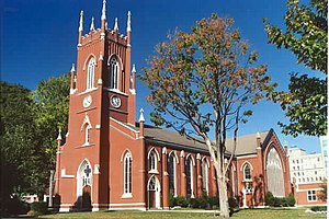
St. Paul's Cathedral in London, Ontario, Canada, is the seat of the Diocese of Huron of the Anglican Church of Canada. It was designed in the Gothic revival style by William Thomas and built between 1844 and 1846, replacing the previous church, which was built in 1834 and burned down in 1844.
Weldon Park Academy
Defunct school in Ontario, Canada
Distance: Approx. 1532 meters
Latitude and longitude: 42.98378,-81.25507
Weldon Park Academy was a private school located at 451 Ridout Street North in London, Ontario that closed down in 2004. The school offered students a contiguous education from Montessori Casa up to OAC and was a member of the Conference of Independent Schools. The Lower School (grades one to five) and Middle School (grades six to eight), were among the best in the city and the staff genuinely cared for the school and its students.

Crystal Palace Barracks
Distance: Approx. 991 meters
Latitude and longitude: 42.99096,-81.24834
The Crystal Palace Barracks in London, Ontario, was the site of the Provincial Exhibition in 1861. The site was chosen at the north end of the military garrison grounds at Wellington Street and Central Avenue. In 1861, the military built an octagonal Crystal Palace, an eight sided white brick building containing eight doors, one on each side.

Western Alumni Stadium
Football stadium in London, Ontario, Canada
Distance: Approx. 1423 meters
Latitude and longitude: 42.99986111,-81.27378056
Western Alumni Stadium (formerly TD Stadium) is an 8,000-seat Canadian football stadium located on the campus of the University of Western Ontario in London, Ontario. It is home to the Western Mustangs football team and is one of the largest stadiums in the OUA provincial conference. It was built in 2000 at a cost of approximately $10.65 million by Norlon Builders London Ltd and designed by Stantec Consulting Ltd.

Home County Music & Art Festival
Folk music and crafts festival in London, Ontario
Distance: Approx. 1177 meters
Latitude and longitude: 42.989,-81.248
The Home County Music & Art Festival (formerly Home County Folk Festival) is a festival held the third weekend of July in London, Ontario. The founders chose the name "H.O.M.E County" because it was an acronym of the nearby counties of Huron, Oxford, Middlesex, and Elgin. The festival is an admission by donation and is held in Victoria Park, London, Ontario.

St. Peter's Cathedral Basilica (London, Ontario)
Church in London, Ontario
Distance: Approx. 1292 meters
Latitude and longitude: 42.98694444,-81.25
St. Peter's Cathedral Basilica, is a church located at 196 Dufferin Avenue in London, Ontario, Canada in the Roman Catholic Diocese of London.

Grand Theatre (London, Ontario)
Theatre in London, Ontario, Canada
Distance: Approx. 1366 meters
Latitude and longitude: 42.98592,-81.251063
The Grand Theatre is a professional theatre located at 471 Richmond Street just south of Dufferin Avenue in London, Ontario, Canada. Its main Spriet Stage has a seating capacity of 839 with a regular season running from September to May. In addition, it has a secondary venue called The Auburn Theatre (previously the McManus Theatre), located on the lower floor with a seating capacity of 150.
Medway-Sydenham Hall
Residence in Ontario, Canada
Distance: Approx. 1326 meters
Latitude and longitude: 43.00826944,-81.26355
Medway-Sydenham Hall (also referred to as Med-Syd or MSH) is a co-ed residence at the University of Western Ontario. It is the third largest residence on campus, home to 613 students. It is also the oldest residence still operating on campus.
Lawson Health Research Institute
Distance: Approx. 348 meters
Latitude and longitude: 43.00014,-81.2543
Lawson Research Institute is the research institute of St. Joseph's Health Care London and works in partnership with the University of Western Ontario.

Eldon House
Historic site in London, Ontario Canada
Distance: Approx. 1412 meters
Latitude and longitude: 42.98484,-81.25545
Eldon House is a historic house and museum located in London, Ontario. The Eldon House property was converted into a public park, now called Harris Park. Eldon House is the oldest continued residence in the city of London.

Dominion Public Building (London, Ontario)
Canadian government offices
Distance: Approx. 1459 meters
Latitude and longitude: 42.98505,-81.25099
The Dominion Public Building is an Art Deco office building located on Richmond Street in the heart of London, Ontario, Canada. Construction on the building started in 1935 and concluded with the building's inauguration in September 1936. The Dominion Public building was a result of the Public Works Construction Act of 1934 which laid out a plan to reinvigorate Canada's economy through public works projects.
Weather in this IP's area
overcast clouds
-6 Celsius
-12 Celsius
-7 Celsius
-6 Celsius
1021 hPa
75 %
1021 hPa
989 hPa
10000 meters
4.63 m/s
250 degree
100 %