Country:
Region:
City:
Latitude and Longitude:
Time Zone:
Postal Code:
IP information under different IP Channel
ip-api
Country
Region
City
ASN
Time Zone
ISP
Blacklist
Proxy
Latitude
Longitude
Postal
Route
Luminati
Country
ASN
Time Zone
Asia/Hong_Kong
ISP
PRIME-SEC
Latitude
Longitude
Postal
IPinfo
Country
Region
City
ASN
Time Zone
ISP
Blacklist
Proxy
Latitude
Longitude
Postal
Route
db-ip
Country
Region
City
ASN
Time Zone
ISP
Blacklist
Proxy
Latitude
Longitude
Postal
Route
ipdata
Country
Region
City
ASN
Time Zone
ISP
Blacklist
Proxy
Latitude
Longitude
Postal
Route
Popular places and events near this IP address

Y.W.C.A. Hioe Tjo Yoeng College
School in Hong Kong
Distance: Approx. 346 meters
Latitude and longitude: 22.3198,114.1831
The Y.W.C.A. Hioe Tjo Yoeng College (HTYC; Chinese: 基督教女青年會丘佐榮中學) is a Hong Kong secondary school. A coeducational school subsidised by the government, it is in the Ho Man Tin, a residential area in Kowloon, Hong Kong. Established in 1971, HTYC is run under the sponsorship YWCA and was founded with a donation from Hioe Tjo Yoeng and his wife.
Pui Ching Middle School (Hong Kong)
Secondary school in Kowloon, Hong Kong
Distance: Approx. 369 meters
Latitude and longitude: 22.3173,114.1767
Pui Ching Middle School (Chinese: 香港培正中學) is a Baptist secondary school in Ho Man Tin, Kowloon, Hong Kong. Founded in 1889, it currently has sister schools in Macau and Guangzhou.
Wa Ying College
Secondary school in Hong Kong
Distance: Approx. 285 meters
Latitude and longitude: 22.31951111,114.18258333
Wa Ying College (also referred to as WYC, Chinese: 華英中學) is a secondary school in Hong Kong, located at 8 Sheung Wo Street, Homantin, Kowloon, Hong Kong. The school is managed by the Methodist Church, Hong Kong.
Hoi Ping Chamber of Commerce Secondary School
Secondary school in Kowloon, Hong Kong
Distance: Approx. 107 meters
Latitude and longitude: 22.31927,114.18075
Hoi Ping Chamber of Commerce Secondary School (Chinese: 旅港開平商會中學, abbr. HPCCSS) is a Band 1 EMI secondary school located in Ho Man Tin, Kowloon Hong Kong. Hoi Ping is also well known for its school athletic team which ranked third in the Hong Kong Inter-School Athletics Competition.

Hong Kong Metropolitan University
Public university in Kowloon, Hong Kong
Distance: Approx. 267 meters
Latitude and longitude: 22.3162,114.18
Hong Kong Metropolitan University (HKMU; as Open University of Hong Kong from 1997 to 2021) is a public university in Ho Man Tin, Kowloon, Hong Kong. Established as the Open Learning Institute of Hong Kong by the Hong Kong government in 1989, HKMU now consists of five schools, namely the School of Arts and Social Sciences, Lee Shau Kee School of Business and Administration, School of Education and Languages, School of Nursing and Health Studies, and the School of Science and Technology. HKMU is the only self-financing university set up by the government.
Chan Sui Ki (La Salle) College
Government funded anglo-chinese boys' school in Kowloon, Hong Kong
Distance: Approx. 368 meters
Latitude and longitude: 22.319431,114.183462
Chan Sui Ki (La Salle) College (Chinese: 陳瑞祺(喇沙)書院) is a Catholic public, Anglo-Chinese boys' secondary school in Ho Man Tin, Kowloon, Hong Kong. The school is established by the Christian Brothers, a Roman Catholic religious teaching order in 1969.In recent years, the public examination results of Chan Sui Ki (La Salle) College have gradually improved. Taking the year 2022 as an example, more than 50% of students achieved the admission requirements for local bachelor's degree programs, making the school a "Band 1" secondary school.
Hong Kong Housing Authority Exhibition Centre
Urban planning museum in Ho Man Tin, Hong Kong
Distance: Approx. 322 meters
Latitude and longitude: 22.3163,114.1819
The Hong Kong Housing Authority Exhibition Centre (Chinese: 香港房屋委員會展覽中心) is managed by Hong Kong Housing Authority. It is located on the 4/F of Block 3, Hong Kong Housing Authority Headquarters, Ho Man Tin. Permanently closed in March, 2022.
Pentecostal School, Hong Kong
School in Ho Man Tin, Kowloon, Hong Kong
Distance: Approx. 343 meters
Latitude and longitude: 22.3213,114.1816
Pentecostal School (simplified Chinese: 五旬节中学; traditional Chinese: 五旬節中學; pinyin: Wǔxúnjié Zhōngxué) is an Anglo-Chinese secondary school founded by the Kowloon Pentecostal Church in Hong Kong in 1973. The school first started off as a non-profit making private school and then became fully subsidized in 1982. The school logo is a flying pigeon symbolizing the Holy Spirit, and with the school motto "Love, Faith and Hope" beneath it.
St. Teresa Secondary School
Secondary school for girls school
Distance: Approx. 30 meters
Latitude and longitude: 22.3188,114.1802
St. Teresa Secondary School (Chinese: 德蘭中學) is a Roman Catholic girls secondary school in Ho Man Tin, Kowloon, Hong Kong. It is directly governed by the Catholic Diocese of Hong Kong.
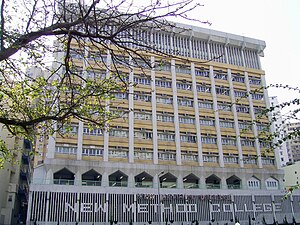
New Method College
School in Hong Kong
Distance: Approx. 122 meters
Latitude and longitude: 22.319,114.1789
New Method College (abbreviated to NMC) was a secondary school located in Black Rock Hill, Kowloon City District, Hong Kong. Its stated mission was "to recognise each student as an individual". It was the fourth school of the same name, with the first one built in 1951 on Hong Kong Island.
Hong Kong College of Technology
Private college in Hong Kong
Distance: Approx. 138 meters
Latitude and longitude: 22.31941111,114.17898056
Hong Kong College of Technology (HKCT, Chinese:香港專業進修學校) is a non-profit-making educational institution under HKCT group. Founded in 1947 as Workers’ Night School, HKCT has been dedicated to the development of vocational and professional education for over 75 years. It offers a diverse ranged of vocational-specific programmes catering to individuals of different ages, backgrounds, and social strata, with the aim of progressing towards becoming a leading Vocational and Professional Education and Training (VPET) university.
Scientia Secondary School
Secondary school in Ho Man Tin, Hong Kong
Distance: Approx. 190 meters
Latitude and longitude: 22.3199,114.1788
Scientia Secondary School (Chinese: 創知中學) is a secondary school in Ho Man Tin, Kowloon, Hong Kong. It was formerly called Workers' Children Secondary School (Chinese: 勞工子弟中學) and, before that, Mongkok Workers' Children School (Chinese: 旺角勞工子弟學校).
Weather in this IP's area
heavy intensity rain
25 Celsius
26 Celsius
24 Celsius
26 Celsius
1013 hPa
91 %
1013 hPa
1007 hPa
10000 meters
4.02 m/s
5.81 m/s
135 degree
41 %
06:36:25
17:39:56


