Country:
 USA
USARegion:
City:
Latitude and Longitude:
Time Zone:
Postal Code:
IP information under different IP Channel
ip-api
Country
Region
City
ASN
Time Zone
ISP
Blacklist
Proxy
Latitude
Longitude
Postal
Route
IPinfo
Country
Region
City
ASN
Time Zone
ISP
Blacklist
Proxy
Latitude
Longitude
Postal
Route
MaxMind
Country
Region
City
ASN
Time Zone
ISP
Blacklist
Proxy
Latitude
Longitude
Postal
Route
Luminati
Country
USRegion
ne
City
omaha
ASN
Time Zone
America/Chicago
ISP
GALLUP1
Latitude
Longitude
Postal
db-ip
Country
Region
City
ASN
Time Zone
ISP
Blacklist
Proxy
Latitude
Longitude
Postal
Route
ipdata
Country
Region
City
ASN
Time Zone
ISP
Blacklist
Proxy
Latitude
Longitude
Postal
Route
Popular places and events near this IP address
Omaha World-Herald
Daily newspaper published in Omaha, Nebraska
Distance: Approx. 330 meters
Latitude and longitude: 41.259,-95.9336
The Omaha World-Herald is a daily newspaper in the midwestern United States, the primary newspaper of the Omaha-Council Bluffs metropolitan area. It was locally owned from its founding in 1885 until 2020, when it was sold to the newspaper chain Lee Enterprises by its most recent local owner, Warren Buffett, chairman of Omaha-based Berkshire Hathaway. For more than a century it circulated daily throughout Nebraska — a state that is 430 miles long.

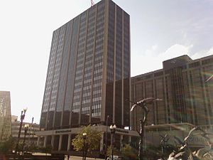
First National Bank Tower
Skyscraper at 1601 Dodge Street in downtown Omaha, Nebraska
Distance: Approx. 331 meters
Latitude and longitude: 41.25916667,-95.93777778
The First National Bank Tower is a 45-story office skyscraper located at 1601 Dodge Street in downtown Omaha, Nebraska, United States, and the official headquarters of First National Bank of Omaha. At 634 ft (193 m) it is the tallest building in Omaha and the state. It has been since its completion, overtaking the 30-story Woodmen Tower located nearby.

Union Pacific Center
Union Pacific Corporate Headquarters in Nebraska, United States
Distance: Approx. 257 meters
Latitude and longitude: 41.2593,-95.9352
The Union Pacific Center at 1400 Douglas Street is a high-rise building in downtown Omaha, Nebraska. It houses the headquarters of the Union Pacific Railroad and its parent company, the Union Pacific Corporation. It officially opened in June 2004 and rises 317 feet (97 m) making it the third tallest building in Omaha.
First National Center (Omaha)
Building in Nebraska, U.S.
Distance: Approx. 261 meters
Latitude and longitude: 41.2601,-95.9379
First National Center is a high-rise office building located at 1620 Dodge Street in Downtown Omaha, Nebraska. It has 22 stories, making it one of the tallest buildings in the city of Omaha. The building is attached to a 19-story, 420-room Doubletree hotel and a 550-stall parking garage.
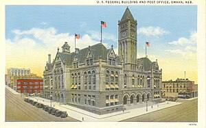
Old Post Office (Omaha, Nebraska)
U.S. post office 1898-1966
Distance: Approx. 245 meters
Latitude and longitude: 41.25986,-95.93729
The Old Post Office was located at 16th and Dodge Streets in Omaha, Nebraska. Built in 1898, the building was demolished in 1966. During the process of being demolished, the building, along with the Old City Hall, became a rallying force for historic preservation in Omaha.
Jefferson Square (Omaha)
Former public park in Nebraska, USA
Distance: Approx. 207 meters
Latitude and longitude: 41.26333333,-95.93638889
Jefferson Square was the last of three original public parks extant in Omaha, Nebraska. Bounded by North 15th, 16th, Chicago and Cass Streets, the park was dedicated on November 25, 1865. It was razed by the city March 18, 1969 to make way for the construction of Interstate 480 in Downtown Omaha.

Stabrie Grocery
United States historic place
Distance: Approx. 300 meters
Latitude and longitude: 41.26388889,-95.93361111
The Stabrie Grocery is a building located at 501 North 13th Street in the NoDo area of Downtown Omaha, Nebraska. Built in 1882, it was added to the National Register of Historic Places in 2007.
Freedom Center (Omaha)
Newspaper production facility in Nebraska, United States
Distance: Approx. 206 meters
Latitude and longitude: 41.26138889,-95.93305556
The John Gottschalk Freedom Center is a newspaper production facility located at 14th Street and Capitol Avenue in Downtown Omaha, Nebraska. Built for the Omaha World-Herald, the building is considered to be one of the most automated and technologically advanced newspaper facilities in the world. The Freedom Center has been labeled a "catalyst" in the redevelopment of Downtown Omaha, along with such other new downtown development as the opening of the Missouri riverfront, the First National Bank Building, the CHI Health Center Omaha and the Gallup University campus.

Trinity Cathedral (Omaha, Nebraska)
Historic church in Nebraska, United States
Distance: Approx. 340 meters
Latitude and longitude: 41.26027778,-95.93916667
Trinity Cathedral is located in Downtown Omaha, Nebraska. Nebraska's first Episcopal parish, Trinity was established in 1856, and became the state's first Episcopal cathedral in 1872. Designed by noted English architect Henry G. Harrison in 1880, the cathedral was consecrated on November 15, 1883.
Market House (Omaha)
Distance: Approx. 220 meters
Latitude and longitude: 41.261,-95.933
The Market House was a controversial fresh produce, meat and fish outlet on Capitol Avenue from North 12th to North 14th Avenues in Downtown Omaha, Nebraska. After almost 40 years of debate and delays in building it, the City of Omaha built the Market House in 1904. The local National Guard squatted in the building for almost 20 years, and afterward it was entirely demolished by 1930.

Rialto Theater (Omaha, Nebraska)
Movie theater in Omaha, Nebraska, US
Distance: Approx. 290 meters
Latitude and longitude: 41.259,-95.9353
The Rialto Theater was a movie theater at 1424 Douglas Street in Downtown Omaha, Nebraska. The building was razed in 1986 and the site paved over for use as a parking lot. The property was later redeveloped as part of the construction of the Union Pacific Railroad's headquarters building.
World Theater (Omaha, Nebraska)
Distance: Approx. 295 meters
Latitude and longitude: 41.259,-95.9362
The World Theater was a vaudeville and movie theater at 1506 Douglas Street in downtown Omaha, Nebraska. Its name was changed to the Omaha Theater in February 1935 when it was sold to new management. It closed on February 26, 1978, and was razed in 1980 to allow for the construction of a parking garage.
Weather in this IP's area
scattered clouds
26 Celsius
26 Celsius
25 Celsius
27 Celsius
1007 hPa
66 %
1007 hPa
973 hPa
10000 meters
7.2 m/s
150 degree
40 %
07:07:43
19:27:48