Country:
Region:
City:
Latitude and Longitude:
Time Zone:
Postal Code:
IP information under different IP Channel
ip-api
Country
Region
City
ASN
Time Zone
ISP
Blacklist
Proxy
Latitude
Longitude
Postal
Route
Luminati
Country
ASN
Time Zone
America/Chicago
ISP
MERIT-AS-14
Latitude
Longitude
Postal
IPinfo
Country
Region
City
ASN
Time Zone
ISP
Blacklist
Proxy
Latitude
Longitude
Postal
Route
db-ip
Country
Region
City
ASN
Time Zone
ISP
Blacklist
Proxy
Latitude
Longitude
Postal
Route
ipdata
Country
Region
City
ASN
Time Zone
ISP
Blacklist
Proxy
Latitude
Longitude
Postal
Route
Popular places and events near this IP address
Kellogg Arena
Arena in Battle Creek, Michigan, USA
Distance: Approx. 138 meters
Latitude and longitude: 42.319098,-85.185478
Kellogg Arena is a 6,200-seat multi-purpose arena located in Battle Creek, Michigan.
Battle Creek Transportation Center
Distance: Approx. 348 meters
Latitude and longitude: 42.31805556,-85.18777778
Battle Creek Transportation Center is an intermodal station in Battle Creek, Michigan, used by Amtrak, Indian Trails and Greyhound Lines. It is at the split between the routes of Amtrak's Blue Water and Wolverine passenger trains. The International Limited, which had started in 1982 as joint operation by Via Rail and Amtrak between Chicago and Toronto, was discontinued in 2004.
St. Philip Catholic Central High School
Private, coeducational school in Battle Creek, Michigan, United States
Distance: Approx. 506 meters
Latitude and longitude: 42.32083333,-85.17861111
St. Philip Catholic Central High School, located in the Roman Catholic Diocese of Kalamazoo, is a Roman Catholic high school in Battle Creek, Michigan.
Battle Creek Central High School
Public high school in Battle Creek, Michigan, United States
Distance: Approx. 408 meters
Latitude and longitude: 42.323643,-85.183003
Battle Creek Central High School (BCCHS) is a public high school in Battle Creek, Michigan, United States. It is the sole high school in the Battle Creek Public Schools district, and one of four public high schools in Battle Creek.
The Rink Battle Creek
Distance: Approx. 413 meters
Latitude and longitude: 42.3199,-85.1897
The Rink, formerly Revolution Arena , is a 1,000 seat multi-purpose arena in Battle Creek, Michigan. It features an 85' x 200' sheet of ice for hockey, figure skating, and open skating. The arena is home to the Battle Creek Bruins and several adult league team.
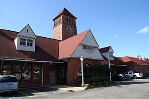
Battle Creek station (Michigan Central Railroad)
Station in Battle Creek, Michigan
Distance: Approx. 291 meters
Latitude and longitude: 42.32111111,-85.18138889
Battle Creek station, listed in the National Register of Historic Places as the Penn Central Railway Station, is a disused train station in Battle Creek, Michigan. It opened on July 27, 1888. Rogers and MacFarlane of Detroit designed the depot, one of several Richardsonian Romanesque-style stations between Detroit and Chicago in the late nineteenth century.

Adam C. Arnold Block
United States historic place
Distance: Approx. 275 meters
Latitude and longitude: 42.31916667,-85.18166667
The Adam C. Arnold Block was a commercial building located at 12-14 East State Street in Battle Creek, Michigan. It was listed on the National Register of Historic Places in 1983. It was demolished in 1988.

W. K. Kellogg House
United States historic place
Distance: Approx. 418 meters
Latitude and longitude: 42.31944444,-85.17972222
The W.K. Kellogg House, located at 1 Monroe Street in Battle Creek, Michigan, was built as a private house for Kellogg Company founder Will Keith Kellogg. It was listed on the National Register of Historic Places in 1985. In 1990, it was moved from its original location at 256 West Van Buren Street to its present location near the W.K. Kellogg Foundation headquarters.

Van Buren Street Historic District
United States historic place
Distance: Approx. 429 meters
Latitude and longitude: 42.32277778,-85.18083333
The Van Buren Street Historic District is a cultural historic district located roughly along Van Buren Street from Capital and Cherry Streets to Calhoun Street and North Avenue in Battle Creek, Michigan. It was listed on the National Register of Historic Places in 1996.

Battle Creek Tower
United States historic place
Distance: Approx. 139 meters
Latitude and longitude: 42.32138889,-85.18416667
The Battle Creek Tower is a mixed-use commercial and residential building located at 70 West Michigan Avenue in Battle Creek, Michigan. It was originally built as the Central National Tower, and designed as an office building. It was listed on the National Register of Historic Places in 2008.

Heritage Tower (Battle Creek, Michigan)
Building in Battle Creek
Distance: Approx. 137 meters
Latitude and longitude: 42.32,-85.18305556
The Heritage Tower is a mixed-use commercial and residential building located at 25 West Michigan Avenue in Battle Creek, Michigan. It was originally built as the Old-Merchants National Bank and Trust Company Building, and designed as an office building. It was listed on the National Register of Historic Places in 2018.

Record Printing and Box Company Building
United States historic place
Distance: Approx. 253 meters
Latitude and longitude: 42.32222222,-85.18611111
The Record Printing and Box Company Building was built as a manufacturing and office building located at 15 Carlyle Street in Battle Creek, Michigan. It was listed on the National Register of Historic Places in 2019. As of 2019, the building was being redeveloped into mixed use commercial space.
Weather in this IP's area
overcast clouds
9 Celsius
9 Celsius
8 Celsius
9 Celsius
1021 hPa
87 %
1021 hPa
990 hPa
10000 meters
100 %
07:33:26
17:18:04
