Country:
Region:
City:
Latitude and Longitude:
Time Zone:
Postal Code:
IP information under different IP Channel
ip-api
Country
Region
City
ASN
Time Zone
ISP
Blacklist
Proxy
Latitude
Longitude
Postal
Route
Luminati
Country
Region
qc
City
montreal
ASN
Time Zone
America/Toronto
ISP
FIBRENOIRE-INTERNET
Latitude
Longitude
Postal
IPinfo
Country
Region
City
ASN
Time Zone
ISP
Blacklist
Proxy
Latitude
Longitude
Postal
Route
db-ip
Country
Region
City
ASN
Time Zone
ISP
Blacklist
Proxy
Latitude
Longitude
Postal
Route
ipdata
Country
Region
City
ASN
Time Zone
ISP
Blacklist
Proxy
Latitude
Longitude
Postal
Route
Popular places and events near this IP address

Old Montreal
Neighbourhood of Montreal in Quebec, Canada
Distance: Approx. 259 meters
Latitude and longitude: 45.505,-73.555
Old Montreal (French: Vieux-Montréal) is a historic neighbourhood within the municipality of Montreal in the province of Quebec, Canada. Home to the Old Port of Montreal, the neighbourhood is bordered on the west by McGill Street, on the north by Ruelle des Fortifications, on the east by rue Saint-André, and on the south by the Saint Lawrence River. Following recent amendments, the neighbourhood has expanded to include the Rue des Soeurs Grises in the west, Saint Antoine Street in the north, and Saint Hubert Street in the east.

Old Port of Montreal
Port in Canada
Distance: Approx. 103 meters
Latitude and longitude: 45.504886,-73.552386
The Old Port of Montreal (French: Vieux-Port de Montréal) is the historic port of Montreal, Quebec, Canada. Located adjacent to Old Montreal, it stretches for over 2 km (1.2 mi) along the Saint Lawrence River. It was used as early as 1611, when French fur traders used it as a trading post.

Pointe-à-Callière Museum
Archaeology and history museum in Quebec, Canada
Distance: Approx. 231 meters
Latitude and longitude: 45.50261111,-73.55419444
Pointe-à-Callière Museum (French: Musée Pointe-à-Callière) is a museum of archaeology and history in Old Montreal, Quebec, Canada. It was founded in 1992 as part of celebrations to mark Montreal's 350th birthday. The museum has collections of artifacts from the First Nations of the Montreal region that illustrate how various cultures coexisted and interacted, and how the French and British empires influenced the history of this territory over the years.

Saint-Paul Street (Montreal)
Street in Old Montreal, Canada
Distance: Approx. 210 meters
Latitude and longitude: 45.505339,-73.553888
Rue Saint-Paul (Saint Paul Street) is a street in the Old Montreal historic area of Montreal, Quebec. The street was laid out by François Dollier de Casson, along the route of a path that had bordered a former fort. Saint Paul is Montreal's oldest street and for many years served as its main thoroughfare.

Notre-Dame Basilica (Montreal)
Church in Quebec, Canada
Distance: Approx. 325 meters
Latitude and longitude: 45.50444444,-73.55611111
Notre-Dame Basilica (French: Basilique Notre-Dame) is a minor basilica of the Catholic Church in the historic Old Montreal district of Montreal in Quebec, Canada. It is located at 110 Notre-Dame Street West, at the corner of Saint Sulpice Street. It is situated next to the Saint-Sulpice Seminary and faces the Place d'Armes square.
James O'Donnell (architect)
Irish-American architect
Distance: Approx. 337 meters
Latitude and longitude: 45.50448611,-73.55626389
James O'Donnell (1774–1830) was a noted Irish-American architect in New York City and Montreal.

Old Custom House, Montreal
Historic site in Quebec, Canada
Distance: Approx. 236 meters
Latitude and longitude: 45.502565,-73.554218
The Old Custom House (French: Ancienne-Douane) is a building in what is now Old Montreal, which served as Montreal's first custom house. The building was completed in 1836, designed by Montreal architect John Ostell in the Palladian revival style. It is a National Historic Site of Canada.

Montreal Science Centre
Non-profit / non-governmental Science museum in Quebec, Canada
Distance: Approx. 192 meters
Latitude and longitude: 45.505,-73.55
The Montreal Science Centre (French: Centre des sciences de Montréal) is a science museum in Montreal, Quebec, Canada. It is located on the Quai King-Edward in the Old Port of Montreal. Established in 2000 and originally known as the iSci Centre, the museum changed its name to the Montreal Science Centre in 2002.

Fort Ville-Marie
17th c. French fort
Distance: Approx. 238 meters
Latitude and longitude: 45.5025,-73.55416667
Fort Ville-Marie was a French fortress and settlement established in May 1642 by a company of French settlers, led by Paul de Chomedey de Maisonneuve, on the Island of Montreal in the Saint Lawrence River at the confluence of the Ottawa River, in what is today the province of Quebec, Canada. Its name is French for "City of Mary", a reference to the Blessed Virgin Mary. It is the historic nucleus around which the original settlement of Montreal grew.
Rue de la Commune
Thoroughfare in Montreal, Canada
Distance: Approx. 156 meters
Latitude and longitude: 45.505102,-73.553235
Rue de la Commune (English: De la Commune Street) is a road in Old Montreal, Quebec, Canada which is well used both by Montrealers and by tourists, since it is the home of the Pointe-à-Callière Museum and the Old Port of Montreal. It also extends eastward into the Gay Village, and westward into Griffintown, where it turns north to Wellington Street and becomes the beginning of Peel Street. The road follows the original shore of the Saint Lawrence River.
Saint Pierre River (Montreal)
River in Quebec, Canada
Distance: Approx. 148 meters
Latitude and longitude: 45.50305556,-73.55333333
The Saint Pierre River was a river in the city of Montreal, Quebec, Canada, flowing into the St. Lawrence River. The city of Montreal was founded at its mouth, at the height of the site Pointe-à-Callière Museum.

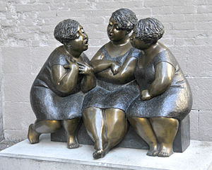
Les chuchoteuses
2002 sculpture by Rose-Aimée Bélanger
Distance: Approx. 215 meters
Latitude and longitude: 45.5053,-73.55404
Les chuchoteuses (English: "The Gossipers") is a 2002 bronze outdoor sculpture by Rose-Aimée Bélanger installed along Montreal's Rue Saint-Paul, in Quebec, Canada, owned by La Société de développement commercial du Vieux-Montréal.
Weather in this IP's area
overcast clouds
13 Celsius
12 Celsius
11 Celsius
13 Celsius
1016 hPa
87 %
1016 hPa
1015 hPa
10000 meters
7.72 m/s
10.29 m/s
170 degree
100 %
06:39:57
16:35:41

