198.153.192.109 - IP Lookup: Free IP Address Lookup, Postal Code Lookup, IP Location Lookup, IP ASN, Public IP
Country:
 USA
USARegion:
City:
Location:
Time Zone:
Postal Code:
ISP:
ASN:
language:
User-Agent:
Proxy IP:
Blacklist:
IP information under different IP Channel
ip-api
Country
Region
City
ASN
Time Zone
ISP
Blacklist
Proxy
Latitude
Longitude
Postal
Route
db-ip
Country
Region
City
ASN
Time Zone
ISP
Blacklist
Proxy
Latitude
Longitude
Postal
Route
IPinfo
Country
Region
City
ASN
Time Zone
ISP
Blacklist
Proxy
Latitude
Longitude
Postal
Route
IP2Location
198.153.192.109Country
usRegion
california
City
mountain view
Time Zone
America/Los_Angeles
ISP
Language
User-Agent
Latitude
Longitude
Postal
ipdata
Country
Region
City
ASN
Time Zone
ISP
Blacklist
Proxy
Latitude
Longitude
Postal
Route
Popular places and events near this IP address

Fruitdale, San Jose
Place in California, United States
Distance: Approx. 2388 meters
Latitude and longitude: 37.31277778,-121.93583333
Fruitdale is a district of San Jose, California, though some portions are still unincorporated as a census-designated place. The population of the CDP was 935 at the 2010 census.

Winchester Mystery House
Mansion in San Jose, California
Distance: Approx. 1344 meters
Latitude and longitude: 37.31836111,-121.95076111
The Winchester Mystery House is a mansion in San Jose, California, that was once the personal residence of Sarah Winchester, the widow of firearms magnate William Wirt Winchester. The house became a tourist attraction nine months after Winchester's death in 1922. The Victorian and Gothic-style mansion is renowned for its size and its architectural curiosities and for the numerous myths and legends surrounding the structure and its former owner.

Harker School
Independent school in San Jose, California, United States
Distance: Approx. 1079 meters
Latitude and longitude: 37.3176,-121.9715
The Harker School is a private, co-educational school located in San Jose, California. Founded in 1893 as Manzanita Hall, Harker now has three campuses: Bucknall, Union, and Saratoga, named after the streets on which they lie. The Bucknall campus houses the Lower School (kindergarten through grade 5), the Union campus houses the Middle School (grades 6–8), and the Saratoga campus houses the Upper School (grades 9 through 12).

Santana Row
Neighborhood of San Jose in Santa Clara County, California, United States
Distance: Approx. 1684 meters
Latitude and longitude: 37.32027778,-121.94777778
Santana Row (abbreviated as SR or The Row) is an upscale residential and commercial district of West San Jose in San Jose, California. Santana Row is intersected by Stevens Creek Boulevard, a major thoroughfare, and close to local landmarks like Westfield Valley Fair and the Winchester Mystery House.
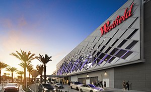
Westfield Valley Fair
Shopping mall in California, U.S.
Distance: Approx. 2386 meters
Latitude and longitude: 37.325095,-121.942508
Westfield Valley Fair, commonly known as Valley Fair, is a prominent shopping mall in San Jose, California. Valley Fair is the largest mall, by area, in Northern California and has higher sales revenue than all other malls in California, including the two in Southern California which have larger area than Valley Fair. Valley Fair is the fourteenth largest shopping mall in the United States.

Boynton High School
School in San Jose, California, United States
Distance: Approx. 338 meters
Latitude and longitude: 37.3106,-121.9665
Boynton High School is a secondary school located in San Jose, California and is a continuation school for the Campbell Union High School District. Between 1990 and 2002 Boynton High School continuation students attended what was then Blackford High School. Blackford had been a traditional high school before 1991 when it was closed.
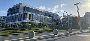
Santa Clara Valley Medical Center
Hospital in California, United States
Distance: Approx. 2565 meters
Latitude and longitude: 37.31333333,-121.93388889
Santa Clara Valley Medical Center, commonly known as Valley Medical Center or simply Valley Medical, is a prominent 731-bed public tertiary, teaching, and research hospital in San Jose, California. Located in the Fruitdale neighborhood of West San Jose, Valley Medical Center is the anchor facility of the Santa Clara County Health System, serving Santa Clara County. Valley Medical is home to numerous innovative research and care centers, such as the Rehabilitation Trauma Center, the only federally-designated spinal cord injury center in Northern California.
Le Papillon (restaurant)
Restaurant in California, United States
Distance: Approx. 1310 meters
Latitude and longitude: 37.31972222,-121.9725
Le Papillon (the French word for butterfly, pronounced [lə papiˈjɔ̃]) is a French restaurant located in San Jose, California. Le Papillon is located on a busy street corner between a hotel and a strip mall. Although the surrounding area is prosaic, the restaurant is "elegant (and expensive)".
Njeri's Morning Glory School and Art Center
School in California, United States
Distance: Approx. 2465 meters
Latitude and longitude: 37.2924,-121.978
Njeri's Morning Glory School and Art Center, was a private elementary school located in San Jose, California, and was registered in the California Department of Education from 2008 until 2020. It was an educational space for parents and children and was a 501(c)3 nonprofit organization. The school fulfilled California's legal and licensing requirements and met health, fire, and safety standards.
Rehabilitation Trauma Center
Hospital in California, United States
Distance: Approx. 2625 meters
Latitude and longitude: 37.314219,-121.933351
The Rehabilitation Trauma Center (RTC) at the Santa Clara Valley Medical Center (SCVMC) was founded in 1972 and is part of the only federally designated spinal cord injury center in Northern California. The center is one of the oldest spinal cord injury neurointensive care units in the United States and participated in the original National Institute on Disability and Rehabilitation Research Database collecting retrospective data to 1973. The center is currently a ten-bed unit based in the Sobrato Pavilion's Respiratory Rehabilitation Unit (opened in 2017) under the direction of Dr.

Moreland School
School district in Santa Clara County, California
Distance: Approx. 1864 meters
Latitude and longitude: 37.30105556,-121.97972222
The Moreland School is a historic landmark in San Jose, Santa Clara County, California, USA, as California's first rural school district in the state in 1851. The first public school building was the former residence of Zechariah Moreland. It was acquired for use as a school on November 13, 1852, through the efforts of the school's third teacher, Samuel Curtis Rogers.

Gubserville, California
Template for California Historical Landmarks in Santa Clara County.
Distance: Approx. 2706 meters
Latitude and longitude: 37.29638889,-121.98722222
Gubserville () was a historic stagecoach, mail, and teamster stop along the road between West San Jose and Saratoga in Santa Clara County, California, United States. The early settlement was named after Frank Gubser, a German immigrant who worked as a barber, saloon keeper, and served as the village's first and only postmaster since July 5, 1882. Gubserville ceased to exist when the post office discontinued operations in 1899.
Weather in this IP's area
scattered clouds
8 Celsius
6 Celsius
7 Celsius
9 Celsius
1025 hPa
83 %
1025 hPa
999 hPa
10000 meters
2.57 m/s
300 degree
40 %