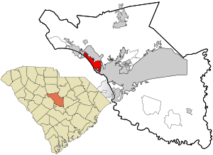
Country:
Region:
City:
Latitude and Longitude:
Time Zone:
Postal Code:
IP information under different IP Channel
ip-api
Country
Region
City
ASN
Time Zone
ISP
Blacklist
Proxy
Latitude
Longitude
Postal
Route
Luminati
Country
ASN
Time Zone
America/Chicago
ISP
IMMEDION
Latitude
Longitude
Postal
IPinfo
Country
Region
City
ASN
Time Zone
ISP
Blacklist
Proxy
Latitude
Longitude
Postal
Route
db-ip
Country
Region
City
ASN
Time Zone
ISP
Blacklist
Proxy
Latitude
Longitude
Postal
Route
ipdata
Country
Region
City
ASN
Time Zone
ISP
Blacklist
Proxy
Latitude
Longitude
Postal
Route
Popular places and events near this IP address
Seven Oaks, South Carolina
Census-designated place in South Carolina, United States
Distance: Approx. 1590 meters
Latitude and longitude: 34.04916667,-81.14194444
Seven Oaks is a census-designated place (CDP) in Lexington County, South Carolina, United States, 8 miles (13 km) northwest of downtown Columbia, the state capital. The population of the CDP was 15,144 at the 2010 census. It is part of the Columbia Metropolitan Statistical Area.

St. Andrews, South Carolina
Census-designated place in South Carolina, United States
Distance: Approx. 4118 meters
Latitude and longitude: 34.04361111,-81.09777778
St. Andrews is a census-designated place (CDP) in Richland County, South Carolina, United States. The population was 20,493 at the 2010 census.
Irmo High School
Public high school in Columbia, South Carolina, United States
Distance: Approx. 3421 meters
Latitude and longitude: 34.06722222,-81.17277778
Irmo High School is a public high school in unincorporated Lexington County, South Carolina, United States, with a Columbia postal address. Irmo High School falls under the administrative jurisdiction of District 5 of Lexington and Richland Counties. It is an International Baccalaureate school.

Columbiana Centre
Shopping mall in Lexington County, South Carolina
Distance: Approx. 2680 meters
Latitude and longitude: 34.07888889,-81.1575
Columbiana Centre is an indoor super-regional shopping mall located off Interstate 26/U.S. Route 76 on Harbison Boulevard in Columbia, South Carolina that opened in 1990. It is the dominant shopping center in the Columbia Metropolitan Area. Most of the mall's territory is located in Lexington County, although portions of the mall extend into Richland County.
WCFJ (FM)
Radio station in Irmo, South Carolina
Distance: Approx. 2352 meters
Latitude and longitude: 34.082,-81.126
WCFJ (92.1 MHz) is a Christian FM radio station affiliated with His Radio and licensed to Irmo, South Carolina and serves the Columbia, South Carolina market. The Hometown Columbia outlet is licensed by the Federal Communications Commission (FCC) to broadcast with an effective radiated power (ERP) of 15 kW. Its studios and transmitter are located in Columbia separately.
Camille Griffin Graham Correctional Institution
State prison for women in Columbia, South Carolina
Distance: Approx. 3565 meters
Latitude and longitude: 34.06944444,-81.09833333
Camille Griffin Graham Correctional Institution is a South Carolina Department of Corrections (SCDC) state prison for women in Columbia, South Carolina. The Women's Reception and Evaluation Center, which processes all females entering SCDC, is in the prison. The prison opened in 1973, as "Women's Correctional Institution".
Broad River Correctional Institution
State prison in South Carolina, US
Distance: Approx. 3761 meters
Latitude and longitude: 34.07416667,-81.09777778
The Broad River Correctional Institution (BRCI) is a South Carolina Department of Corrections state prison for men located in Columbia, South Carolina. South Carolina's execution chamber is located in Broad River. The adjacent Kirkland Correctional Institution lies just to its south side.
Harbison State Forest
State forest in South Carolina, United States
Distance: Approx. 3497 meters
Latitude and longitude: 34.09277778,-81.12555556
Harbison State Forest is a State Forest in Richland County, South Carolina. It is named for Samuel P. Harbison of Pittsburgh, Pennsylvania, who provided the majority of funds for the land purchase. The forest is found in the Midlands region of central South Carolina and comprises 2,177 acres (881.0 ha) of woodland, meadowland, and bottomland located alongside the Broad River in Richland County, South Carolina.
NashiCon
Anime convention
Distance: Approx. 3775 meters
Latitude and longitude: 34.03194444,-81.11861111
NashiCon was an annual three-day anime convention held traditionally during March/April at the DoubleTree by Hilton Hotel Columbia, South Carolina in Columbia, South Carolina. It was the first anime convention in South Carolina and Nashi stands for Nippon Anime Society of Heavenly Imagery.

River Bluff High School
Public school in Lexington, South Carolina, United States
Distance: Approx. 4170 meters
Latitude and longitude: 34.0272,-81.1509
River Bluff High School is one of three public high schools in Lexington, South Carolina, United States. It provides education for ninth through twelfth grades for the town of Lexington and parts of Lake Murray, Oak Grove and West Columbia. It is located on the eastern side of Lexington, the school overlooks the Saluda River and is a few hundred feet from Interstate 20 and U.S. Highway 378.

Pine Grove Rosenwald School
United States historic place
Distance: Approx. 1229 meters
Latitude and longitude: 34.06222222,-81.12277778
Pine Grove Rosenwald School, also known as Pine Grove Colored School, is a historic Rosenwald school building located at St. Andrews, Richland County, South Carolina. It was built in 1923, and is a one-story, rectangular gable-front frame building.
Kirkland Correctional Institution
Prison in Columbia, South Carolina
Distance: Approx. 3540 meters
Latitude and longitude: 34.06944444,-81.09861111
Kirkland Correctional Institution is a state prison for men located in Columbia, Richland County, South Carolina, United States, owned and operated by the South Carolina Department of Corrections. Kirkland has a special role in South Carolina's prison system as the point of intake and assessment for all male state prisoners, the site of the state's Maximum Security Unit, and a health care facility. The prison was first opened in 1975, and houses a maximum of 1707 inmates, plus another 50 in the Max unit and 24 in the infirmary.
Weather in this IP's area
overcast clouds
9 Celsius
7 Celsius
8 Celsius
10 Celsius
1016 hPa
91 %
1016 hPa
1005 hPa
10000 meters
2.06 m/s
100 %
06:57:46
17:20:56
