Country:
 Somalia
Region:
City:
Latitude and Longitude:
Time Zone:
Postal Code:
IP information under different IP Channel
ip-api
Country
Region
City
ASN
Time Zone
ISP
Blacklist
Proxy
Latitude
Longitude
Postal
Route
IPinfo
Country
Region
City
ASN
Time Zone
ISP
Blacklist
Proxy
Latitude
Longitude
Postal
Route
MaxMind
Country
Region
City
ASN
Time Zone
ISP
Blacklist
Proxy
Latitude
Longitude
Postal
Route
Luminati
Country
SORegion
by
City
baidoa
ASN
Time Zone
Africa/Mogadishu
ISP
TELESOM
Latitude
Longitude
Postal
db-ip
Country
Region
City
ASN
Time Zone
ISP
Blacklist
Proxy
Latitude
Longitude
Postal
Route
ipdata
Country
Region
City
ASN
Time Zone
ISP
Blacklist
Proxy
Latitude
Longitude
Postal
Route
Popular places and events near this IP address
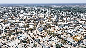
Baidoa
City in the South West State of Somalia.
Distance: Approx. 1077 meters
Latitude and longitude: 3.11666667,43.65
Baidoa (Arabic: بَيْطَبَوْ, Somali (Af-Maxaa): Baydhabo, Maay: Baydhowy) is the largest city of the South West State of Somalia. Between 2002 and 2014, Baidoa was the capital of the South West State. In 2014, the capital was changed to Barawa.
Baidoa Airport
Airport in Bay, Somalia
Distance: Approx. 3653 meters
Latitude and longitude: 3.09266667,43.61783333
Shatigadud International Airport Baidoa Somalia (IATA: BIB, ICAO: HCMB) is an airport serving Baidoa, the capital city of the Bay region in Somalia. It has been used by both civilian and military aircraft. The airport was built in the 1960s, and at the time was 8,800 feet long and 150 feet wide, before being resurfaced with asphalt and lengthened to 9,600 feet in 1974 with Soviet support.
Weather in this IP's area
clear sky
33 Celsius
33 Celsius
33 Celsius
33 Celsius
1011 hPa
35 %
1011 hPa
964 hPa
10000 meters
6.77 m/s
6.5 m/s
202 degree
3 %
05:51:22
17:55:56