197.156.241.178 - IP Lookup: Free IP Address Lookup, Postal Code Lookup, IP Location Lookup, IP ASN, Public IP
Country:
Region:
City:
Location:
Time Zone:
Postal Code:
ISP:
ASN:
language:
User-Agent:
Proxy IP:
Blacklist:
IP information under different IP Channel
ip-api
Country
Region
City
ASN
Time Zone
ISP
Blacklist
Proxy
Latitude
Longitude
Postal
Route
db-ip
Country
Region
City
ASN
Time Zone
ISP
Blacklist
Proxy
Latitude
Longitude
Postal
Route
IPinfo
Country
Region
City
ASN
Time Zone
ISP
Blacklist
Proxy
Latitude
Longitude
Postal
Route
IP2Location
197.156.241.178Country
Region
kaduna
City
zaria
Time Zone
Africa/Lagos
ISP
Language
User-Agent
Latitude
Longitude
Postal
ipdata
Country
Region
City
ASN
Time Zone
ISP
Blacklist
Proxy
Latitude
Longitude
Postal
Route
Popular places and events near this IP address

Zaria
City in Kaduna State, Nigeria
Distance: Approx. 5553 meters
Latitude and longitude: 11.06666667,7.7
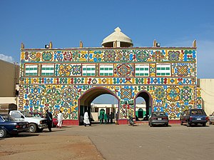
Zaria is a metropolitan city in Nigeria, located at present time within four local government areas in Kaduna State. It serves as the capital of the Zazzau Emirate Council and is one of the original seven Hausa city-states. The local government areas comprising Zaria are Zaria, Sabon Gari, Giwa, and Soba local government areas of Kaduna State, Nigeria.

Barewa College
Secondary school in Zaria, Kaduna State, Nigeria
Distance: Approx. 3893 meters
Latitude and longitude: 11.085278,7.698889
Barewa College is a college in Zaria, Kaduna State, northern Nigeria. Founded in 1921 by British governor general Hugh Clifford, it was originally known as Katsina College. It switched its name to Kaduna College in 1938 and to Government College, Zaria in 1949 before settling on Barewa College.
Wusasa
Town in Kaduna State, Nigeria
Distance: Approx. 5684 meters
Latitude and longitude: 11.075475,7.68562778
Wusasa is a town just outside the major city of Zaria in Kaduna State in Northern Nigeria.
Nigerian College of Aviation Technology
Nigeria aviation school
Distance: Approx. 4734 meters
Latitude and longitude: 11.13611111,7.6875
The Nigerian College of Aviation Technology is a higher education institute in Zaria, Kaduna State, Nigeria. It is funded by the Civil Aviation Department in the Nigerian Federal Ministry of Aviation. Formerly known as the Nigerian Civil Aviation Training Centre, the school was established in 1964.
Sabon Gari, Nigeria
LGA and town in Kaduna State, Nigeria
Distance: Approx. 1306 meters
Latitude and longitude: 11.11666667,7.73333333
Sabon Gari Local Government is a local government area in Kaduna State, Nigeria. It is one of the local government areas in the Zaria metropolis as well as being one of the districts of the Zazzau Emirate Council. The towns and villages are Dogarawa, Bomo, Basawa, Zabi, Samaru, Kwari, Barashi, Muchiya and Palladan.
Zaria Quds Day massacres
Attack on a Quds Day parade by the Nigerian military
Distance: Approx. 5553 meters
Latitude and longitude: 11.06666667,7.7
Zaria Quds massacres (or Zaria Quds massacres) refers to an incident on 25 July 2014, when the Nigerian Army opened fire on members of the Islamic Movement who were taking part in Quds day rallies, and killed 35 people, including three sons of Ibrahim Zakzaky, leader of the movement. The Islamic Movement and Islamic Human Rights Commission claimed that Nigerian government's ties with Israel were responsible for the attacks on the pro-Palestinian group.
2015 Zaria massacre
Armed attack by the Nigerian military on the Shia community of Zaria, Kaduna, Nigeria
Distance: Approx. 5553 meters
Latitude and longitude: 11.06666667,7.7
The Zaria massacre, also known as the Buhari massacre, was a massacre carried out by the Nigerian Army in Zaria, Kaduna State, Nigeria, on Saturday, 12 December 2015, against Shia Muslims, mostly members of the Islamic Movement in Nigeria (IMN). At least 1000 civilians were killed, with 347 bodies secretly buried by the Army in a mass grave. The Army claimed that it had responded to an attempt to assassinate Nigeria's Chief of Army Staff, Tukur Buratai, by the IMN. This claim has been strongly rejected by the IMN and several human rights organizations who argue that the massacre occurred without any provocation and that all the protestors were unarmed.
Federal College of Education, Zaria
College in Zaria, Nigeria
Distance: Approx. 3204 meters
Latitude and longitude: 11.084,7.732
Federal College of Education, Zaria now Federal University of Education, Zaria, was a college of science and art in Zaria, Nigeria. It was established by the then Northern Region Government of Nigeria in November 1962. It was initially named Northern Secondary Teachers College and later known as Advanced Teachers' College Zaria, under the administrative and policy control of Ahmadu Bello University Zaria, until 1991.
Ahmadu Bello University
Public University in Zaria, Nigeria
Distance: Approx. 5553 meters
Latitude and longitude: 11.06666667,7.7
The Ahmadu Bello University (ABU) is a public research university located in Zaria, Kaduna State, Nigeria. It was opened in 1962 as the University of Northern Nigeria. The university has four colleges, three schools, 18 faculties, 110 academic departments, 17 centres, and seven institutes with over 600 professors, about 3000 academic staff and over 7000 non-teaching staff.
Nigeria research reactor-1
Research reactor in Nigeria
Distance: Approx. 8663 meters
Latitude and longitude: 11.1512,7.6546
The Nigeria research reactor (NIRR-1) is a nuclear research reactor located in Zaria, Nigeria. The reactor is located at the Centre for Energy Research and Training (CERT), part of Ahmadu Bello University. The reactor had its first criticality in 2004, launched by the then director of CERT, Prof.
Abiola Ajimobi Technical University
State University in Oyo, Nigeria
Distance: Approx. 5553 meters
Latitude and longitude: 11.06666667,7.7
Abiola Ajimobi Technical University formerly known as the First Technical University, Ibadan is a state-owned and the first technical University in Nigeria located in Oyo state. It was approved by National Universities Commission in 2012. The University was renamed Abiola Ajimobi Technical University by Seyi Makinde in honour of the immediate past Governor of Oyo State, Abiola Ajimobi.
Weather in this IP's area
clear sky
32 Celsius
30 Celsius
32 Celsius
32 Celsius
1012 hPa
11 %
1012 hPa
942 hPa
10000 meters
7.77 m/s
8.61 m/s
69 degree