Country:
 Namibia
Region:
City:
Latitude and Longitude:
Time Zone:
Postal Code:
IP information under different IP Channel
ip-api
Country
Region
City
ASN
Time Zone
ISP
Blacklist
Proxy
Latitude
Longitude
Postal
Route
IPinfo
Country
Region
City
ASN
Time Zone
ISP
Blacklist
Proxy
Latitude
Longitude
Postal
Route
MaxMind
Country
Region
City
ASN
Time Zone
ISP
Blacklist
Proxy
Latitude
Longitude
Postal
Route
Luminati
Country
NAASN
Time Zone
Africa/Windhoek
ISP
Paratus
Latitude
Longitude
Postal
db-ip
Country
Region
City
ASN
Time Zone
ISP
Blacklist
Proxy
Latitude
Longitude
Postal
Route
ipdata
Country
Region
City
ASN
Time Zone
ISP
Blacklist
Proxy
Latitude
Longitude
Postal
Route
Popular places and events near this IP address

University of Namibia
Public university in Windhoek, Namibia
Distance: Approx. 1895 meters
Latitude and longitude: -22.61111111,17.0575
The University of Namibia (UNAM) is a multi-campus public research university in Namibia, and the largest university in the country. It was established by an act of Parliament on 31 August 1992.
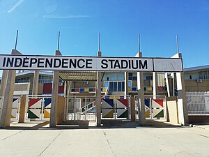
Independence Stadium (Namibia)
Distance: Approx. 1774 meters
Latitude and longitude: -22.60765278,17.09097222
The Independence Stadium in Windhoek's Olympia suburb is the national stadium of the Republic of Namibia. Owned by the Government of Namibia it holds 25,000 spectators and is mainly used for association football events. As of 2021, the stadium has been described as "dilapidated".

Windhoek Country Club Resort
Distance: Approx. 1510 meters
Latitude and longitude: -22.61722222,17.07694444
The Windhoek Country Club Resort is a multi-use resort outside of Windhoek, Namibia owned by the Government of Namibia, and managed by Legacy Hotels and Resorts International. The Resort was opened in May 1995 and was home to the 1995 Miss Universe Pageant. The resort's golf course is home to the yearly Bank Windhoek Namibian Open Golf Tournament.
Namibia University of Science and Technology
Institute of tertiary education in Windhoek, Namibia
Distance: Approx. 1895 meters
Latitude and longitude: -22.61111111,17.0575
The Namibia University of Science and Technology (NUST), formerly known as Polytechnic of Namibia, is a public university located in the city of Windhoek, Namibia. NUST was headed by the founding vice-chancellor Tjama Tjivikua until March 2019. After two acting appointments, Erold Naomab was appointed vice-chancellor in January 2021.
UNAM Radio
Radio station in Windhoek, Namibia
Distance: Approx. 1895 meters
Latitude and longitude: -22.61111111,17.0575
UNAM Radio is the radio station of the University of Namibia. It broadcasts on 97.4 FM and is based in Windhoek, Namibia. Established in 2000, UNAM Radio is part of the University of Namibia mission to increase students' practical involvement with media and also to highlight the university's activities to the wider community.

Hage Geingob Rugby Stadium
Distance: Approx. 1765 meters
Latitude and longitude: -22.6076,17.0909
The Hage Geingob Stadium (previously known as the South West Stadium) is a rugby stadium in Windhoek, Namibia. It is named after Hage Geingob, the president of Namibia. The stadium has a capacity of 10,000.

Pioneers Park
Suburb of Windhoek, Namibia
Distance: Approx. 1569 meters
Latitude and longitude: -22.5911,17.0678
Pioneers Park (also Pionierspark) is a suburb in the south of Windhoek, Namibia, in the Windhoek West parliamentary constituency. It was developed in the second half of the 20th century as a white community, with the previous black residents being expelled to Katutura. The suburb is mainly residential, but also contains the main campus of the University of Namibia.
Academia Secondary School
Secondary school in Windhoek, Namibia
Distance: Approx. 1003 meters
Latitude and longitude: -22.60909722,17.06623056
Academia Secondary School is a secondary school in Windhoek, Namibia. It is situated in the Academia suburb. Forty years ago on 22 January 1975, Academia Secondary School opened for the first time with 19 staff members and 227 pupils in Standard 5 to 7 (now Grade 7 to 9), led by the Principal PJ Scholtz.

Windhoek West Constituency
Electoral constituency in Windhoek, Namibia
Distance: Approx. 2077 meters
Latitude and longitude: -22.58849722,17.06279722
Windhoek West Constituency is an electoral constituency in the Khomas Region of Namibia. It contains the affluent suburbs of Hochland Park, Pioneers Park, Academia, Cimbebasia, Rocky Crest, Windhoek North and Windhoek West. It had a population of 53,438 in 2011, up from 42,201 in 2001.
Wanderers Cricket Ground
Sports venue in Windhoek, Namibia
Distance: Approx. 1396 meters
Latitude and longitude: -22.59156389,17.07175556
Wanderers Cricket Ground is a cricket ground in Windhoek, Namibia. The first recorded match on the ground was in 1990 when Namibia played the Netherlands. The ground held its first List A match in the 2001/02 6 Nations Challenge when Namibia played Sri Lanka A. In 2004, the ground held its first first-class match between Namibia and Uganda in the 2004 Intercontinental Cup.
Affies Park
Cricket ground
Distance: Approx. 1361 meters
Latitude and longitude: -22.59226974,17.07011413
Affies Park, formerly Windhoek Afrikaans Primary School Ground, is a cricket ground in Windhoek, Namibia. The first recorded match on the ground was in 2014. It was used as a venue for matches in the 2015 ICC World Cricket League Division Two tournament.
National Earth Science Museum
Earth Science Museum
Distance: Approx. 1016 meters
Latitude and longitude: -22.6008,17.0835
The National Earth Science Museum (also known as the Geological Survey Museum) in Windhoek is Namibia's central geological museum. It is maintained by the State Geological Survey of Namibia under the Ministry of Mines and Energy.
Weather in this IP's area
clear sky
29 Celsius
27 Celsius
27 Celsius
30 Celsius
1013 hPa
8 %
1013 hPa
839 hPa
10000 meters
2.06 m/s
40 degree
06:15:45
18:57:09