Country:
Region:
City:
Latitude and Longitude:
Time Zone:
Postal Code:
IP information under different IP Channel
ip-api
Country
Region
City
ASN
Time Zone
ISP
Blacklist
Proxy
Latitude
Longitude
Postal
Route
Luminati
Country
ASN
Time Zone
Africa/Lubumbashi
ISP
Satellite Mediaport Services Ltd.
Latitude
Longitude
Postal
IPinfo
Country
Region
City
ASN
Time Zone
ISP
Blacklist
Proxy
Latitude
Longitude
Postal
Route
db-ip
Country
Region
City
ASN
Time Zone
ISP
Blacklist
Proxy
Latitude
Longitude
Postal
Route
ipdata
Country
Region
City
ASN
Time Zone
ISP
Blacklist
Proxy
Latitude
Longitude
Postal
Route
Popular places and events near this IP address

Matadi
Provincial capital and city in Kongo Central, Democratic Republic of the Congo
Distance: Approx. 4441 meters
Latitude and longitude: -5.81666667,13.48333333
Matadi is the chief sea port of the Democratic Republic of the Congo and the capital of the Kongo Central province, adjacent to the border with Angola. It had a population of 245,862 (2004). Matadi is situated on the left bank of the Congo River, 148 km (92 mi) from the mouth and 8 km (5.0 mi) below the last navigable point before the rapids that make the river impassable for a long stretch upriver.

Kongo Central
Province of the Democratic Republic of the Congo
Distance: Approx. 4441 meters
Latitude and longitude: -5.81666667,13.48333333
Kongo Central (Kongo: Kongo dia Kati), formerly Bas-Congo, is one of the 26 provinces of the Democratic Republic of the Congo. Its capital is Matadi.

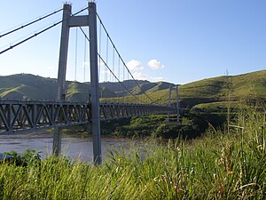
Matadi Bridge
Bridge over the Kongo River
Distance: Approx. 4340 meters
Latitude and longitude: -5.824466,13.433865
The Matadi Bridge, also known as the OEBK Bridge for Organisation pour l’équipement de Banana-Kinshasa, and formerly known as Pont Maréchal in French, is a suspension bridge across the Congo River at Matadi, Democratic Republic of the Congo. It was completed in 1983 by a consortium of Japanese companies. With a main span of 520 metres (1,710 ft), it was the longest suspension bridge in Africa from its inauguration until the 2018 opening of the Maputo–Katembe bridge.

Matadi–Kinshasa Railway
Railway line in Democratic Republic of the Congo
Distance: Approx. 4707 meters
Latitude and longitude: -5.8195,13.4912
The Matadi–Kinshasa Railway (French: Chemin de fer Matadi-Kinshasa) is a railway line in Kongo Central province between Kinshasa, the capital of Democratic Republic of the Congo, and the port of Matadi. The Matadi–Kinshasa Railway was built between 1890 and 1898 in order to bypass the series of rapids and falls which hindered access from the South Atlantic Ocean to the Congo Basin. Its length is 366 km (227 mi) and it is run by Société commerciale des transports et des ports (SCTP) (until 2011, ONATRA).
Ango-Ango
Distance: Approx. 1410 meters
Latitude and longitude: -5.85,13.45
Ango Ango is a town in the Bas-Congo province of the Democratic Republic of the Congo.
Mpozo
Distance: Approx. 4569 meters
Latitude and longitude: -5.83333333,13.5
Mpozo is a town in the Bas-Congo province of the Democratic Republic of the Congo near the border with Angola.
Noqui
Municipality and town in Zaire Province, Angola
Distance: Approx. 3853 meters
Latitude and longitude: -5.86805556,13.4325
Noqui (or Noki) is a town and municipality in Zaire Province in Angola. It is on the Congo River, just across the border from the city of Matadi in the Democratic Republic of the Congo. The municipality had a population of 23,880 in 2014.

M'pozo River
Distance: Approx. 4952 meters
Latitude and longitude: -5.81139,13.4833
The M'pozo (French: Rivière M'pozo) is a river in the province of Bas-Congo in the Democratic Republic of the Congo. Its source is located in Angola and it forms part of the Angola–Democratic Republic of the Congo border. The river ends on the left bank of the Congo River, a few kilometres upstream of Matadi.
Nzanza
A commune in the town of Matadi in the Democratic Republic of Congo
Distance: Approx. 3747 meters
Latitude and longitude: -5.818,13.47
Nzanza is a commune of the city of Matadi in the Democratic Republic of the Congo.

Matadi Tshimpi Airport
Airport
Distance: Approx. 6183 meters
Latitude and longitude: -5.8,13.44027778
Matadi Tshimpi Airport (IATA: MAT, ICAO: FZAM) is an airport serving the city of Matadi in Kongo Central Province, Democratic Republic of the Congo. The runway is north of Matadi, across the Congo River. The Matadi NDB (Ident: MS) is 1 kilometre (0.62 mi) southeast of the runway.

Hotel Métropole, Matadi
Distance: Approx. 3290 meters
Latitude and longitude: -5.821434,13.460002
Hôtel Métropole is a hotel in Matadi, Democratic Republic of Congo. Constructed in a Gothic Revival style by Belgian architect Ernest Callebout, it first opened in 1930.

Bas-Congo District
District in Democratic Republic of the Congo
Distance: Approx. 4440 meters
Latitude and longitude: -5.816667,13.483333
Bas-Congo (French: District du Bas-Congo, Dutch: District Beneden-Congo) was a district of the Belgian Congo and the Democratic Republic of the Congo. It went through various significant changes in extent. It roughly corresponds to the present province of Kongo Central.
Weather in this IP's area
light rain
24 Celsius
25 Celsius
24 Celsius
24 Celsius
1012 hPa
87 %
1012 hPa
976 hPa
10000 meters
1.84 m/s
4.45 m/s
273 degree
64 %
05:39:34
18:02:39