196.3.115.28 - IP Lookup: Free IP Address Lookup, Postal Code Lookup, IP Location Lookup, IP ASN, Public IP
Country:
Region:
City:
Location:
Time Zone:
Postal Code:
IP information under different IP Channel
ip-api
Country
Region
City
ASN
Time Zone
ISP
Blacklist
Proxy
Latitude
Longitude
Postal
Route
Luminati
Country
ASN
Time Zone
Africa/Johannesburg
ISP
SAIX-NET
Latitude
Longitude
Postal
IPinfo
Country
Region
City
ASN
Time Zone
ISP
Blacklist
Proxy
Latitude
Longitude
Postal
Route
IP2Location
196.3.115.28Country
Region
eastern cape
City
port elizabeth
Time Zone
Africa/Johannesburg
ISP
Language
User-Agent
Latitude
Longitude
Postal
db-ip
Country
Region
City
ASN
Time Zone
ISP
Blacklist
Proxy
Latitude
Longitude
Postal
Route
ipdata
Country
Region
City
ASN
Time Zone
ISP
Blacklist
Proxy
Latitude
Longitude
Postal
Route
Popular places and events near this IP address

Nelson Mandela Bay Metropolitan Municipality
Metropolitan municipality in Eastern Cape, South Africa
Distance: Approx. 4507 meters
Latitude and longitude: -33.95,25.6
The Nelson Mandela Bay Municipality (Xhosa: uMasipala oMbaxa iNelson Mandela Bay; Afrikaans: Nelson Mandelabaai Metropolitaanse Munisipaliteit) is one of eight metropolitan municipalities in South Africa. It is located on the shores of Algoa Bay in the Eastern Cape province and comprises the city of Gqeberha, the nearby towns of Uitenhage and Despatch, and the surrounding rural area. The name "Nelson Mandela Bay Metropolitan Municipality" was chosen to honour former President Nelson Mandela.

Sarah Baartman District Municipality
District municipality in Eastern Cape, South Africa
Distance: Approx. 4507 meters
Latitude and longitude: -33.95,25.6
The Sarah Baartman District Municipality (Xhosa: uMasipala weSithili sase Sarah Baartman; Afrikaans: Sarah Baartman-distriksmunisipaliteit), formerly the Cacadu District Municipality, is situated in the western part of the Eastern Cape province of South Africa, covering an area of 58,242 square kilometres. The area of the district municipality includes seven local municipalities. The seat is the city of Gqeberha, although Gqeberha is not itself in the district (it is in the Nelson Mandela Bay Metropolitan Municipality).
New Brighton, Eastern Cape
Place in Eastern Cape, South Africa
Distance: Approx. 3125 meters
Latitude and longitude: -33.899,25.595
New Brighton is a township in the Eastern Cape, South Africa. It forms part of the greater township of Ibhayi and the Nelson Mandela Bay Metropolitan Municipality which governs Port Elizabeth and its surroundings.

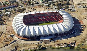
Nelson Mandela Bay Stadium
Stadium in Gqeberha, South Africa
Distance: Approx. 3452 meters
Latitude and longitude: -33.93777778,25.59888889
The Nelson Mandela Bay Stadium is a soccer and rugby union stadium in Gqeberha in the Eastern Cape province of South Africa. It hosted 2010 FIFA World Cup matches, including the third-place play off. It is the home of Chippa United Football Club and formerly of rugby union team Southern Kings.
Westering High School
Public high school in Port Elizabeth, Eastern Cape, South Africa
Distance: Approx. 4242 meters
Latitude and longitude: -33.93234444,25.52755833
Westering High School is a public co-ed high school in Westering, Port Elizabeth, South Africa catering for English-speaking students from grade 8 to 12.
Roman Catholic Diocese of Port Elizabeth
Roman Catholic diocese in South Africa
Distance: Approx. 4507 meters
Latitude and longitude: -33.95,25.6
The Roman Catholic Diocese of Port Elizabeth (Latin: Portus Elizabethen(sis)) is a diocese located in the city of Port Elizabeth in the ecclesiastical province of Cape Town in South Africa.

Red Location Museum
Museum in South Africa
Distance: Approx. 3964 meters
Latitude and longitude: -33.898134,25.605708
The Red Location Museum is a museum in the New Brighton township of Port Elizabeth, South Africa. The museum was opened to the public on 10 November 2006 as a tribute to the struggle against Apartheid. It is situated in a shack settlement that is one of the oldest townships in Port Elizabeth.
Livingstone Hospital
Hospital in Eastern Cape, South Africa
Distance: Approx. 807 meters
Latitude and longitude: -33.92524,25.56976
Livingstone Hospital is a large Provincial government-funded hospital situated in Korsten, Port Elizabeth in South Africa. It is a tertiary hospital and forms part of the Port Elizabeth Hospital Complex. The hospital departments include The Emergency Department, the Paediatric, the Out Patients Department, Surgical Services, Medical Services, Operating Theatre & CSSD Services, a Pharmacy, Anti-Retroviral (ARV) treatment for HIV/AIDS Wellness Clinic/ID clinic, Post Trauma Counseling Services, Occupational Services, X-ray Services, Occupational Therapy, Physiotherapy, Speech Therapy, NHLS Laboratory, Oral Health Care Provides Maxillofacial Facial, Laundry Services, Kitchen Services and a Mortuary.
Dora Nginza Hospital
Hospital in Eastern Cape, South Africa
Distance: Approx. 4626 meters
Latitude and longitude: -33.8773,25.56
Dora Nginza Hospital is a large Provincial government funded hospital, situated on Spondo Street in Zwide township of Gqeberha in South Africa. It is a tertiary teaching hospital and forms part of the Port Elizabeth Hospital Complex. The hospital departments include Emergency department, Neonatal and Paediatric wards, Maternity ward, Obstetrics/Gynecology, Psychiatry [ 35 bed Acute Mental Health Unit], Outpatient Adult and Child Psychiatry Clinics, Out Patients Department, Surgical Services, Medical Services, Operating Theatre & CSSD Services, Pharmacy, Anti-Retroviral (ARV) treatment for HIV/AIDS, Post Trauma Counseling Services, Occupational Services, X-ray Services, Occupational Therapy, Speech Therapy, Physiotherapy, NHLS Laboratory, Oral Health Care Provides, Laundry Services, Kitchen Services and Mortuary, Dietitians, Lactation Consultation, The only functional Burn Unit (Paediatric and Adult) in the Eastern Cape.
Kensington, Gqeberha
Place in Eastern Cape, South Africa
Distance: Approx. 3578 meters
Latitude and longitude: -33.9416,25.5964
Kensington is an inner-city suburb of Gqeberha, Eastern Cape, South Africa.
Isaac Wolfson Stadium
Distance: Approx. 4399 meters
Latitude and longitude: -33.884463,25.595285
The Wolfson Stadium is a sports stadium in KwaZakele, Ibhayi just outside Port Elizabeth in South Africa. The stadium is able to hold 10,000 people. and is occasionally used to host rugby union matches by the Eastern Province Elephants and Southern Kings and football matches by Chippa United.
Collegiate Girls High School
Distance: Approx. 4046 meters
Latitude and longitude: -33.95057968,25.5895231
Collegiate Girls High School is a public English-speaking medium high school for girls in Parsons Hill, Gqeberha, in the Eastern Cape province of South Africa.
Weather in this IP's area
broken clouds
21 Celsius
21 Celsius
21 Celsius
21 Celsius
1017 hPa
92 %
1017 hPa
1013 hPa
10000 meters
3.13 m/s
5.36 m/s
64 degree
53 %