Country:
 Mauritius
Region:
City:
Latitude and Longitude:
Time Zone:
Postal Code:
IP information under different IP Channel
ip-api
Country
Region
City
ASN
Time Zone
ISP
Blacklist
Proxy
Latitude
Longitude
Postal
Route
IPinfo
Country
Region
City
ASN
Time Zone
ISP
Blacklist
Proxy
Latitude
Longitude
Postal
Route
MaxMind
Country
Region
City
ASN
Time Zone
ISP
Blacklist
Proxy
Latitude
Longitude
Postal
Route
Luminati
Country
MUASN
Time Zone
Indian/Mauritius
ISP
MauritiusTelecom
Latitude
Longitude
Postal
db-ip
Country
Region
City
ASN
Time Zone
ISP
Blacklist
Proxy
Latitude
Longitude
Postal
Route
ipdata
Country
Region
City
ASN
Time Zone
ISP
Blacklist
Proxy
Latitude
Longitude
Postal
Route
Popular places and events near this IP address

Mauritius
Island country in the Indian Ocean
Distance: Approx. 1993 meters
Latitude and longitude: -20.2,57.5
Mauritius, officially the Republic of Mauritius, is an island nation in the Indian Ocean, about 2,000 kilometres (1,100 nautical miles) off the southeastern coast of East Africa, east of Madagascar. It includes the main island (also called Mauritius), as well as Rodrigues, Agaléga, and St. Brandon (Cargados Carajos shoals).
Moka
Villages in Moka District, Mauritius
Distance: Approx. 3214 meters
Latitude and longitude: -20.219,57.496
Moka (Mauritian Creole pronunciation: [moka]) is a village in Mauritius located mainly in the Moka District. The western part of the village lies in the Plaines Wilhems District. Since 1967 it forms part of Constituency No.
Outer Islands of Mauritius
Distance: Approx. 1993 meters
Latitude and longitude: -20.2,57.5
The Outer Islands of Mauritius (French: Îles éparses de Maurice) is the first-level administrative divisions of the country and consists of the islands of Mauritius and several outlying islands. The Outer Islands of Mauritius are managed under the aegis of the Prime Minister of Mauritius through Prime Minister's Office by the Outer Islands Development Corporation which is the authority empowered under the law to manage the Outer Islands of Mauritius. The Prime Minister is also Minister for Rodrigues, Outer Islands and Territorial Integrity.
University of Technology, Mauritius
Public research university in Port Louis
Distance: Approx. 2406 meters
Latitude and longitude: -20.17678483,57.46728983
The University of Technology, Mauritius (UTM) is a public research university in Mauritius. The main campus lies in La Tour Koenig, Pointe-aux-Sables, within the district of Port-Louis. It was founded following the government of Mauritius approval of the setting up of the University of Technology, Mauritius in January 2000 and the proclamation of The University of Technology, Mauritius Act on 21 June 2000.
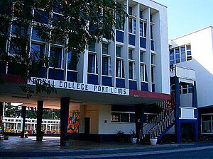
Royal College Port Louis
School in Port Louis, Mauritius
Distance: Approx. 3208 meters
Latitude and longitude: -20.16445,57.48571
The Royal College Port Louis (RCPL) is an academy in Cassis, Mauritius. It is regarded as one of the most prestigious secondary schools in Mauritius. Originally founded in 1799 during the French colonial period, the first stone of the school's current building at Cassis was laid by Princess Margaret during her first visit to Mauritius in 1956.
Dr James Burty David SSS
School in Port Louis, Mauritius
Distance: Approx. 2077 meters
Latitude and longitude: -20.174485,57.483765
Dr James Burty David State Secondary School is a state secondary school based in Bell Village, Port Louis, Mauritius. Students are prepared for the School Certificate and the Higher School Certificate.

British Mauritius
British colony in Africa from 1810 to 1968
Distance: Approx. 1993 meters
Latitude and longitude: -20.2,57.5
Mauritius was a Crown colony off the southeast coast of Africa. Formerly part of the French colonial empire, British rule in Mauritius was established de facto with the Invasion of Isle de France in November 1810, and de jure by the subsequent Treaty of Paris. British rule ended on 12 March 1968, when Mauritius became independent.

Dutch Mauritius
Former Dutch colony
Distance: Approx. 1993 meters
Latitude and longitude: -20.2,57.5
Mauritius was an official settlement of the Dutch East India Company on the island of Mauritius between 1638 and 1710, and used as a refreshing station for passing ships. It was already frequented by Dutch ships from 1598 onwards, but only settled in 1638, to prevent the French and the British from settling on the island.
Mauritius (1968–1992)
Monarchy of Mauritius with Elizabeth II as head of state
Distance: Approx. 1993 meters
Latitude and longitude: -20.2,57.5
Between independence in 1968 and becoming a republic in 1992, Mauritius was an independent sovereign state that shared its head of state with the United Kingdom and other states headed by Elizabeth II. In 1968, the United Kingdom's Mauritius Independence Act 1968 granted independence to the British Crown Colony of Mauritius. The British monarch, Elizabeth II, remained head of state as Queen of Mauritius, as well as being Queen of the United Kingdom and the other Commonwealth realms. The monarch's constitutional roles in Mauritius were mostly delegated to the Governor-General of Mauritius.
National Archives of Mauritius
National archives of the Republic of Mauritius
Distance: Approx. 1573 meters
Latitude and longitude: -20.1884,57.4682
The National Archives of Mauritius are located in Coromandel, Mauritius. The archives were officially established in 1815, one of the earliest such institutions established in the Southern Hemisphere.
Radio Plus (Mauritius)
Private Radio Station in Mauritius
Distance: Approx. 3040 meters
Latitude and longitude: -20.1718718,57.5007039
Radioplus is a private radio station owned and broadcast by Defimedia group, a leading media and communication company in Mauritius. It started operation in 2002 with a private commercial free to air FM radio broadcasting licence issued by the Independent Broadcasting Authority - Mauritius. Radio Plus's slogan is "Ecoute ou Pou tende" (English: Listen you will hear, French: Ecoutez vous allez entendre).
Coromandel, Mauritius
Suburb of Municipality of Beau Bassin Rose Hill in the Republic of Mauritius
Distance: Approx. 1818 meters
Latitude and longitude: -20.1879,57.4659
Coromandel is a suburb of the Municipality of Beau Bassin-Rose Hill in the Republic of Mauritius. It is a three-border region located at the edge of the Plaine Wilhems, Port Louis and Black River Districts. The postcode for Coromandel is 71608 and it is home to the Coromandel Industrial Zone and the Coromandel Metro Express Station.
Weather in this IP's area
scattered clouds
24 Celsius
25 Celsius
24 Celsius
25 Celsius
1023 hPa
79 %
1023 hPa
1013 hPa
10000 meters
0.45 m/s
3.13 m/s
58 degree
47 %
06:12:35
18:03:12