Country:
 South Africa
Region:
City:
Latitude and Longitude:
Time Zone:
Postal Code:
IP information under different IP Channel
ip-api
Country
Region
City
ASN
Time Zone
ISP
Blacklist
Proxy
Latitude
Longitude
Postal
Route
IPinfo
Country
Region
City
ASN
Time Zone
ISP
Blacklist
Proxy
Latitude
Longitude
Postal
Route
MaxMind
Country
Region
City
ASN
Time Zone
ISP
Blacklist
Proxy
Latitude
Longitude
Postal
Route
Luminati
Country
ZAASN
Time Zone
Africa/Johannesburg
ISP
xneelo
Latitude
Longitude
Postal
db-ip
Country
Region
City
ASN
Time Zone
ISP
Blacklist
Proxy
Latitude
Longitude
Postal
Route
ipdata
Country
Region
City
ASN
Time Zone
ISP
Blacklist
Proxy
Latitude
Longitude
Postal
Route
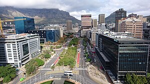
Popular places and events near this IP address
Purple Rain protest
Distance: Approx. 235 meters
Latitude and longitude: -33.92222222,18.42055556
The Purple Rain Protest, Purple Rain Revolt or Purple Rain Riot was an anti-apartheid protest held in Cape Town on 2 September 1989, four days before South Africa's racially segregated parliament held its elections. A police water cannon with purple dye was turned on thousands of Mass Democratic Movement supporters who poured into the city in an attempt to march on South Africa's Parliament. White office blocks adjacent to Greenmarket Square were sprayed purple four stories high as a protester leapt onto the roof of the water cannon vehicle, seized the nozzle and attempted to turn the jet away from the crowds.
Adderley Street
Major street in CBD of Cape Town, South Africa
Distance: Approx. 126 meters
Latitude and longitude: -33.92138889,18.42416667
Adderley Street is a street in Cape Town, South Africa. It is considered the main street of the central business district (downtown) of Cape Town. The Christmas lights, night markets, main train station and numerous shops and restaurants and office towers are on this thoroughfare.

Greenmarket Square
Historical square in old Cape Town, South Africa
Distance: Approx. 287 meters
Latitude and longitude: -33.92222222,18.42
Greenmarket Square is a historical square in the centre of old Cape Town, South Africa. The square was built in 1696, when a burgher watch house was erected. Over the years, the square has served as a slave market, a vegetable market, a parking lot and more recently, a flea market trading mainly African souvenirs, crafts and curios.

Fort de Goede Hoop
Former fortification in Cape Town
Distance: Approx. 250 meters
Latitude and longitude: -33.92416667,18.42416667
The Fort de Goede Hoop ('Fort of Good Hope') was the first military building to be erected in what is now Cape Town. It was built in 1652, and was in use until 1674 when it was superseded by the Castle of Good Hope.

Mutual Building
Building in Cape Town, South Africa
Distance: Approx. 244 meters
Latitude and longitude: -33.92416667,18.42222222
The Mutual Building (Afrikaans: Mutual Gebou), in Cape Town, South Africa, was built as the headquarters of the South African Mutual Life Assurance Society, now the "Old Mutual" insurance and financial services company. It was opened in 1940, but before the end of the 1950s—less than 20 years later—business operations were already moving to another new office at Mutual Park in Pinelands (north east of the city centre); since then Old Mutual has become an international business and their present head office is in Johannesburg. The building is a fine example of art deco architecture and design, and it has many interesting internal features such as the banking hall, assembly room, directors' board room; external features include a dramatic ziggurat structure, prismoid (triangular) windows, and one of the longest carved stone friezes in the world.

Koopmans-de Wet House
Historic site, Museum in Cape Town, South Africa
Distance: Approx. 211 meters
Latitude and longitude: -33.920941,18.421291
Koopmans-de Wet House (locally KOORP-munz də VET) is a former residence and current museum in Strand Street, Cape Town, South Africa. The house became part of the South African Museum in 1913 and was opened to the public on 10 March 1914. It was declared a National Monument under National Monuments Council legislation on 1 November 1940.

Trams in Cape Town
Former South African public transport system
Distance: Approx. 134 meters
Latitude and longitude: -33.92305556,18.42222222
Cape Town, South Africa, has had two tramway networks forming part of its public transport arrangements. Both networks are now long closed.
Heritage Western Cape
Provincial heritage resources authority of South Africa
Distance: Approx. 282 meters
Latitude and longitude: -33.92305556,18.42027778
Heritage Western Cape (HWC) is a provincial heritage resources authority established by the Minister of Cultural Affairs and Sport of the government of the Western Cape province in South Africa. It is a public entity set up under the terms of the National Heritage Resources Act. It is mandated to care for that part of South Africa's national estate that is of provincial and local significance in the Western Cape.

South African Sendinggestig Museum
Church Museum in Long Street, Cape Town
Distance: Approx. 254 meters
Latitude and longitude: -33.921335,18.420509
The South African Sendinggestig Museum (also known as the South African Slave Church Museum) was established in 1977 and is currently situated in the centre of Cape Town, Western Cape, South Africa. It is a province-aided museum which receives support from the Government of the Western Cape Province.
Atterbury House
Office skyscraper in Cape Town, South Africa
Distance: Approx. 208 meters
Latitude and longitude: -33.9202349,18.4229172
Atterbury House (formerly known as Shell House) is a 417 ft (127 m) office skyscraper in Cape Town, South Africa. The 29 story building was completed in 1976. At the time it was completed, it became the 2nd tallest building in Cape Town, shorter than the 423 ft (129 m) 1 Thibault Square.

Golden Acre (Cape Town)
Commercial centre in Cape Town
Distance: Approx. 72 meters
Latitude and longitude: -33.9227486,18.4231529
The Golden Acre is a shopping mall on the corner of Adderley and Strand Streets in downtown Cape Town.

Foreshore Place
Skyscraper in Cape Town
Distance: Approx. 238 meters
Latitude and longitude: -33.92027778,18.42444444
Foreshore Place (formerly ABSA Centre) is a mixed-use skyscraper in Cape Town, South Africa.
Weather in this IP's area
few clouds
22 Celsius
22 Celsius
21 Celsius
23 Celsius
1015 hPa
69 %
1015 hPa
1013 hPa
10000 meters
3.58 m/s
6.71 m/s
115 degree
18 %
06:13:19
18:53:57