Country:
 South Africa
Region:
City:
Latitude and Longitude:
Time Zone:
Postal Code:
IP information under different IP Channel
ip-api
Country
Region
City
ASN
Time Zone
ISP
Blacklist
Proxy
Latitude
Longitude
Postal
Route
IPinfo
Country
Region
City
ASN
Time Zone
ISP
Blacklist
Proxy
Latitude
Longitude
Postal
Route
MaxMind
Country
Region
City
ASN
Time Zone
ISP
Blacklist
Proxy
Latitude
Longitude
Postal
Route
Luminati
Country
ZAASN
Time Zone
Africa/Johannesburg
ISP
xneelo
Latitude
Longitude
Postal
db-ip
Country
Region
City
ASN
Time Zone
ISP
Blacklist
Proxy
Latitude
Longitude
Postal
Route
ipdata
Country
Region
City
ASN
Time Zone
ISP
Blacklist
Proxy
Latitude
Longitude
Postal
Route
Popular places and events near this IP address
Bellville Velodrome
Multi-purpose indoor velodrome in Bellville, Cape Town, South Africa
Distance: Approx. 1663 meters
Latitude and longitude: -33.87979167,18.63351111
The Techtonic Velodrome is a 250-meter, multi-purpose indoor velodrome located in Bellville, South Africa. The venue has served as Greater Cape Town's main concert venue and has now been replaced by the Cape Town Stadium. Its maximum capacity for cycling competition would range from 5 to 8,000.

Institute for Futures Research
Distance: Approx. 2418 meters
Latitude and longitude: -33.88459722,18.626975
The Institute for Futures Research (IFR), established in 1974, is a research institution of the University of Stellenbosch specialising in futurology, primarily as a support service for knowledge and strategic management.

Hoërskool Bellville
School in Bellville, Western Cape, South Africa
Distance: Approx. 3066 meters
Latitude and longitude: -33.89284167,18.64862778
Hoërskool Bellville (Bellville High School) is a public Afrikaans medium co-educational high school situated in Bellville in the Western Cape province of South Africa, It is one of the top schools in the Western Cape province, It was founded in 1937.

Stellenbosch Business School
Distance: Approx. 2418 meters
Latitude and longitude: -33.88459722,18.626975
Stellenbosch Business School is the business school of the University of Stellenbosch in Bellville, Western Cape, South Africa.

Durbanville Nature Reserve
Piece of protected land next to the Durbanville Racecourse
Distance: Approx. 2826 meters
Latitude and longitude: -33.84082,18.64352
Durbanville Nature Reserve is a 6-hectare (15-acre) piece of protected land, located next to the Hollywoodbets Durbanville Racecourse in the Western Cape, South Africa.
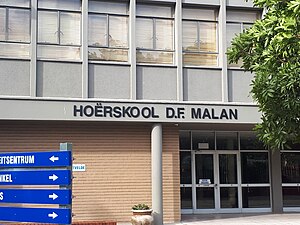
D.F. Malan High School
High School in Bellville, Western Cape, South Africa
Distance: Approx. 3331 meters
Latitude and longitude: -33.8936,18.6265
Hoërskool D.F. Malan is a public Afrikaans medium co-educational high school situated in the suburb of Boston, Bellville in the Western Cape province of South Africa - near Cape Town. It was named after D.F Malan, the prime minister of South Africa from 1948 to 1954. In 2012 and 2013, the school was included in The Cambridge University Student Guide to Excellence, a selection of 100 top schools worldwide.

Stellenberg High School
School in Cape Town, Western Cape, South Africa
Distance: Approx. 1987 meters
Latitude and longitude: -33.8637,18.662
Stellenberg High School is a public dual-medium (Afrikaans and English), co-educational high school located in Stellenberg, Bellville in the Western Cape province of South Africa. It is one of the top and prestigious schools in the Western Cape. The high school was established in 1986.
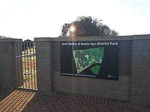
Jack Muller Danie Uys Park
Distance: Approx. 2924 meters
Latitude and longitude: -33.889896,18.627293
The Jack Muller Danie Uys Park is a municipal park situated in Boston, Bellville, Western Cape, South Africa.

Bellville historical clay and stone quarry and adjacent jail
Distance: Approx. 1621 meters
Latitude and longitude: -33.8764,18.6283
In 1930 the owners of the land (the company “Brick and Clay") started mining activities on a 260 hectare piece of land situated in Bellville, Western Cape , South Africa. In 1936 a Jail was built next to the Quarry. Today very little of the Quarry and Jail is left and it was replaced with modern city infrastructure.
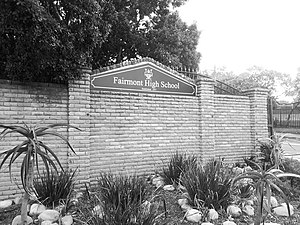
Fairmont High School, Durbanville
School in Durbanville, Western Cape, South Africa
Distance: Approx. 1380 meters
Latitude and longitude: -33.8537,18.6407
Fairmont High School is a public English medium co-educational high school situated in the town of Durbanville in the Western Cape province of South Africa.

Dutch Reformed Church, Durbanville
Church in Durbanville, South Africa
Distance: Approx. 3323 meters
Latitude and longitude: -33.83665,18.64659
The Dutch Reformed Church in Durbanville is a church building of the Dutch Reformed Church in Durbanville, South Africa, built in 1825 in the Cape Dutch style. The village was then still called Pompoenkraal. A separate bell tower has been built near the church with a bell visible from the outside.
Welgemoed, Bellville
Suburb in Western Cape, South Africa
Distance: Approx. 2275 meters
Latitude and longitude: -33.87361111,18.61780556
Welgemoed is an upmarket residential suburb of Bellville in the Western Cape, South Africa. It is situated approximately 4 kilometres (2.5 mi) north-west of the Bellville CBD and 22 kilometres (13.7 mi) north-east of Cape Town.
Weather in this IP's area
few clouds
18 Celsius
18 Celsius
18 Celsius
19 Celsius
1015 hPa
76 %
1015 hPa
994 hPa
10000 meters
2.15 m/s
2.8 m/s
273 degree
13 %
06:12:29
18:53:03