Country:
 Senegal
Region:
City:
Latitude and Longitude:
Time Zone:
Postal Code:
IP information under different IP Channel
ip-api
Country
Region
City
ASN
Time Zone
ISP
Blacklist
Proxy
Latitude
Longitude
Postal
Route
IPinfo
Country
Region
City
ASN
Time Zone
ISP
Blacklist
Proxy
Latitude
Longitude
Postal
Route
MaxMind
Country
Region
City
ASN
Time Zone
ISP
Blacklist
Proxy
Latitude
Longitude
Postal
Route
Luminati
Country
SNRegion
dk
City
dakar
ASN
Time Zone
Africa/Dakar
ISP
SONATEL SONATEL-AS Autonomous System
Latitude
Longitude
Postal
db-ip
Country
Region
City
ASN
Time Zone
ISP
Blacklist
Proxy
Latitude
Longitude
Postal
Route
ipdata
Country
Region
City
ASN
Time Zone
ISP
Blacklist
Proxy
Latitude
Longitude
Postal
Route
Popular places and events near this IP address
Saint-Louis, Senegal
City and commune in Saint-Louis Region, Senegal
Distance: Approx. 2047 meters
Latitude and longitude: 16.03333333,-16.5
Saint-Louis or Saint Louis (Wolof: Ndar), is the capital of Senegal's Saint-Louis Region. Located in the northwest of Senegal, near the mouth of the Senegal River, and 320 kilometres (200 mi) north of Senegal's capital city Dakar. It had a population of 254,171 in 2023.
Gaston Berger University
Public university in Senegal
Distance: Approx. 8437 meters
Latitude and longitude: 16.0625,-16.42583333
Gaston Berger University (GBU), or L'Université Gaston Berger (UGB), located some 12 km (7.5 mi) outside Saint-Louis, was the second university established in Senegal (the first being Cheikh Anta Diop University). Originally the University of Saint-Louis, it was renamed for Gaston Berger, an important French-Senegalese philosopher, on December 4, 1996.

Roman Catholic Diocese of Saint-Louis du Sénégal
Roman Catholic diocese in Senegal
Distance: Approx. 1760 meters
Latitude and longitude: 16.0248,-16.5044
The Roman Catholic Diocese of Saint-Louis du Sénégal (Latin: Sancti Ludovici Senegalen(sis), French: Diocèse catholique romain de Saint-Louis du Sénégal) is a diocese located in the city of Saint-Louis in the ecclesiastical province of Dakar in Senegal.
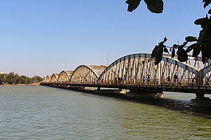
Faidherbe Bridge
Road bridge in Senegal
Distance: Approx. 1514 meters
Latitude and longitude: 16.02580556,-16.50111111
Faidherbe Bridge (French: Pont Faidherbe) is a road bridge over the Senegal River which links the island of the city of Saint-Louis in Senegal to the African mainland. The metal bridge is 507.35 m (1,664.5 ft) long and 10.5 m (34 ft) wide, weighing 1,500 t (1,500 long tons; 1,700 short tons). It has eight spans, of which the longest five are 78.26 m (256.8 ft).
Stade de Linguère
Multi-use stadium in Saint-Louis, Senegal
Distance: Approx. 656 meters
Latitude and longitude: 16.0228,-16.493
Stade de Linguère, better known as Stade Mawade Wade is a multi-use stadium in Saint-Louis, Senegal. It is currently used mostly for football matches and serves as a home ground of ASC Linguère of the Senegal Premier League. It is also home to another club known as Saint-Louis FC The stadium holds 8,000 spectators.

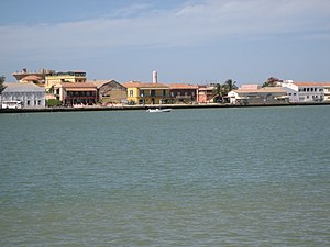
Island of Saint-Louis
Distance: Approx. 1932 meters
Latitude and longitude: 16.02778,-16.50444
The Island of Saint-Louis is the historic part of the city of Saint-Louis in Senegal. In 2000, it was inscribed by the UNESCO on the World Heritage list.

British capture of Senegal
1758 battle
Distance: Approx. 2044 meters
Latitude and longitude: 16.0333,-16.5
The British capture of Senegal took place in 1758 during the Seven Years' War with France, as part of a concerted British strategy to weaken the French economy by damaging her international trade. To this end, a succession of small British military expeditions landed in Senegal and captured Gorée and Fort Saint Louis, the French slave fort located at Saint-Louis, seizing French vessels and supplies. By late 1758 the whole of the French colony on the Senegalese coast had been captured by the British, with administrative matters being handled by the first (and only) British Governor of Senegal, Lieutenant Colonel Richard Worge.

St. Louis Cathedral (Saint-Louis, Senegal)
Catholic cathedral in Senegal
Distance: Approx. 1760 meters
Latitude and longitude: 16.0248,-16.5044
The Cathedral of St. Louis (French: Cathédrale Saint Louis), located in Saint-Louis, Senegal, is the seat of the Diocese of St-Louis du Sénégal. The nineteenth-century cathedral church is located on the place d'armes in the southern district of Saint-Louis Island.
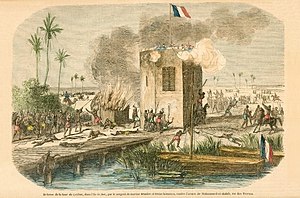
Battle of Leybar Bridge
Distance: Approx. 4199 meters
Latitude and longitude: 15.9807,-16.4831
The Battle of Leybar Bridge was fought on 21 April 1855 between the Trarza army of Mohammed al-Habib and the French garrison of the tower on Leybar Bridge, outside of Saint-Louis in the French colony of Senegal, during the Second Franco-Trarza War.

Saint-Louis Photography Museum
Photography museum in Saint-Louis, Senegal
Distance: Approx. 1816 meters
Latitude and longitude: 16.023899,-16.50538
The Saint-Louis Photography Museum (French: Musée de la Photographie de Saint-Louis) is a museum located in Saint-Louis, Senegal. It is the first museum in Senegal dedicated to photography.
Weather in this IP's area
broken clouds
32 Celsius
39 Celsius
32 Celsius
32 Celsius
1014 hPa
66 %
1014 hPa
1013 hPa
10000 meters
4.12 m/s
320 degree
75 %
06:57:27
18:46:55